


To read a more recent trip report in the Mount Margaret Backcountry, check out One Night at Bear Camp in the Mount Margaret Backcountry.
The last weekend of July I went backpacking with friends and family in the Mount Margaret Backcountry. This will be a brief trip report on that excursion!
Overview
- Two nights (July 24-26, 2020)
- Total Mileage: ~20.2 miles
- Trailhead: Norway Pass Trailhead (Northwest Forest Pass)
- Permits/Fees: Backpacking permit cost: $6/site/night
- Camps: Panhandle Lake Camp, Dome Camp
Day 1
Destination:
Trail Conditions
There was one part of the trail that required some focus. The picture is below.
This is not far past the Independence Trail junction on the Boundary Trail. We didn't have that much trouble with the washout, but there is ~15 ft. of exposure to a lower trail that some other hikers have bushwacked that didn't want to risk the small traverse.
The Lakes Trail was a bit overgrown on the other side of Bear Pass as we hiked to Panhandle Lake. There were some branches that we had to duck under, and washouts that garnered more focus from time to time. Furthermore, there are a couple spots on the Lakes Trail, in between Bear Pass and Obscurity Lake that have steep dropoffs.
Hiking was much easier on the Boundary Trail. We were going to stop for a break at Grizzly Lake, but there wasn't really a place to sit off the trail.
The trail got a little better by Obscurity and beyond but still overgrown in many spots. It's wasn't too annoying, but definitely noticeable.
Water
There is water at the trailhead that can be pumped by spinning a wheel. It seemed pretty clean, but we just used it to wash our faces. I don't remember any water between the trailhead and Bear Pass. After we got over Bear Pass there was some stream run off above Grizzly Lake that was good water to filter.
Water could also be filtered at either Grizzly or Obscurity, which aren't that far apart.
Panhandle Lake Camp
It felt like a long day by the time we crested the ridge between Obscurity and Panhandle Lake before dropping down to our camp for the first night. The Panhandle Lake basin is compact and beautiful.
We saw a lone mountain goat on the high ridge to the south of the lake that we watched for a few minutes.
If you are hiking from the east then you'll see the camps down below and feel like you're hiking past them. However, you cross the snow-fed stream that feeds into Panhandle and then continue even further towards the middle of the lake before there is a sign and trail that goes down the camps.
The two toilets were about as much as you could expect from a backcountry privy. It's worth noting that they didn't provide a whole lot of privacy from people on the upper trail, or down on the camp trail.
There is a stream that separates the toilets and camps. It was overgrown when we were there, but not hard to cross.
It's a great place to filter cold and freshwater. It's also not very far from the two camps.
I think that camp closest to the lake is clearly the better of the two. Regardless, the other permit holder didn't show up that night, so we had the lake to ourselves.
The camp closer to the lake has some bushes for privacy and a nice sandy area to cook food or hang out. It also has a nice path to the lake.
We had four people, but all with separate single person tents (out of an abundance of caution in the times of COVID). Not all fit on the single platform, but we squeezed them in to the walking areas to try our best and protect the plant life.
It was windy and cold so the bugs weren't a bother the night we were at Panhandle. However, there were plenty of ants. A few times we had to get up quickly and brush ourselves off this trip.
The sun peaked out a few times that afternoon but the breeze was cold and we were tired so it was an early night.
Being down in the lake basin protects you from the wind. We had a much better night of sleep than some other backpackers who were up at Bear Camp. We talked to them on the trail during the second day and they told us it was very windy!
Day 2
Destination:
Awoke to beautiful weather the second day. I could not wait to get up and take it all in. I saw our goat friend on the high slope for a few minutes that morning while I watched the sunrise chase down the rocks towards the lake.
The bugs became a nuisance as we made food by the camp, so we had to deal with a few bites.
We took our time getting things packed up and didn't hit the trail until 9:40 a.m. We were all taking a few pictures, and enjoying some coffee by the lake.
Trail Conditions
We had to deal with the same trail conditions as we hiked back along the Lake Trail to Bear Pass. However, back on the Boundary Trail things were all good. It can be a narrow trail but easy to get a good rhythm going.
There's not much reprieve from the sun on the Boundary Trail, but we know that going in. We had hats, sunglasses, and plenty of sunscreen.
We had to cross a few small and melting snow patches on the trail. None of which required additional traction.
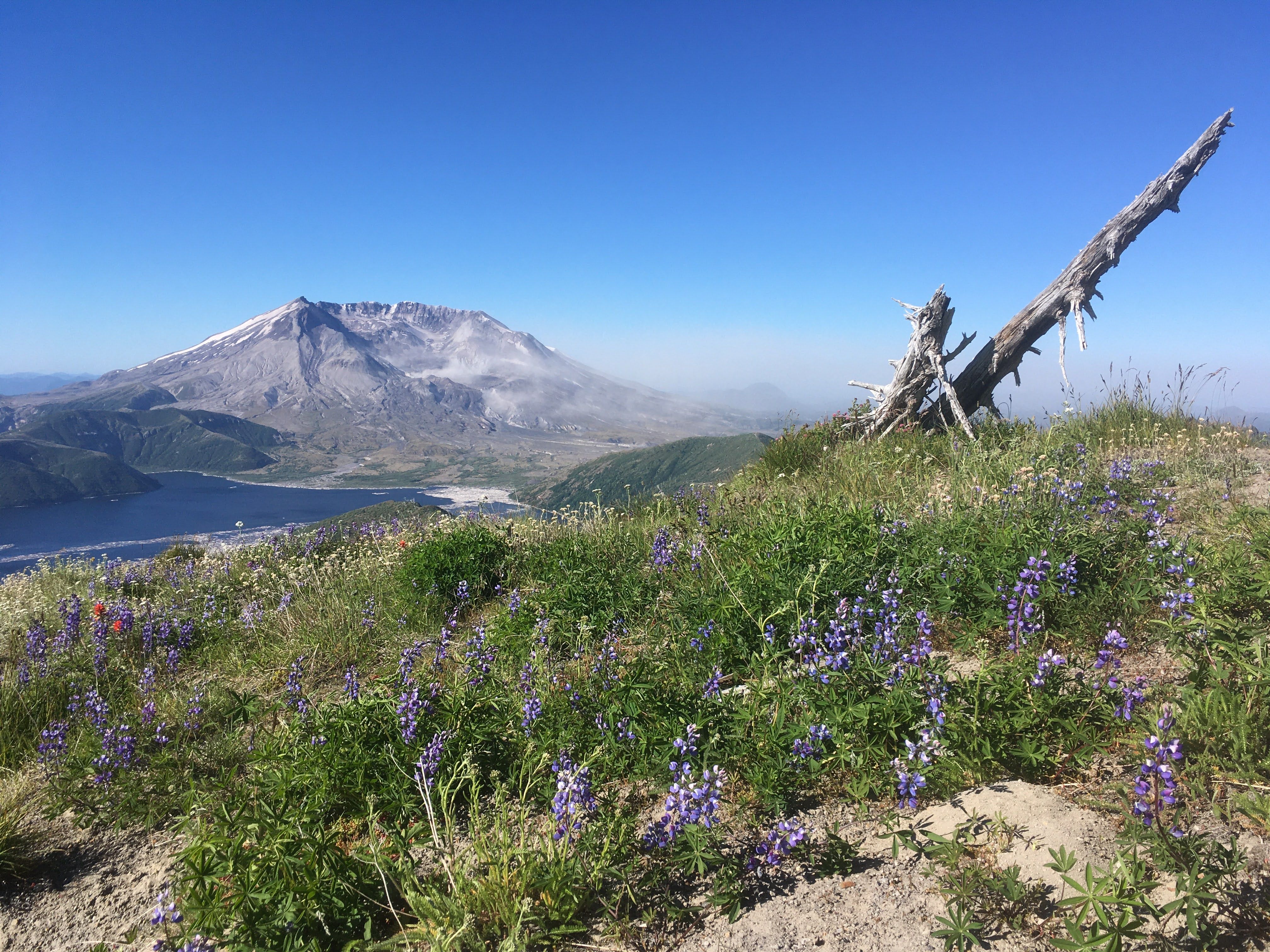
Wildflowers were blooming on most of the slopes around the trail giving a nice accent to mountain scenery.
I expected it to be much busier on a sunny Saturday in July, but we had Bear Pass to ourselves and didn't think the trail was that crowded most of the day.
Water
We filtered water at camp before we left, but could have filtered again at either Obscurity or Grizzly.
Bear Camp had a perfect stream to filter water at. We sat in some of the snowfields to cool off as well. It's about 1.5 miles past Bear Pass and 2-2.5 miles from Margaret Camp and Dome Camp.
Margaret Camp had a nice little stream of snow run-off to filter as well. Dome Camp's spring was small and getting smaller, but still very usable. With the varying climate from year-to-year, it's worth noting that the water sources are seasonal at the camps along the Boundary Trail.
The Hike
As we climbed towards Bear Pass we saw Mt. Rainier and Adams emerge from behind the near slopes. We were excited to reach Bear Pass and get our first real view of Mt. St. Helens, too. Also, we were looking forward to being off the Lakes Trail.
Bear Pass is a pretty special vantage point. To the south is Spirit Lake and Mt. St. Helens. To the north is Mt. Rainier (the panorama above is a 180-degree view with St. Helens and Rainier). Mt. Adams is to the East, and Mt. Hood can be seen to the south-southeast.
We talked to some older backpackers that had worked at Spirit Lake some forty years ago before the eruption. They told us about how the eruption knocked down trees at Bear Pass exposing Mt. Adams. Also, how the snow level on the Boundary Trail caused the 10-15 ft. stumps along the trail. They said you can almost see the snow level in May of 1980 by observing the stumps' height in certain areas.
Hiking along the Boundary Trail, with Mt. St. Helens by your side, is gorgeous country.
We stopped at Bear Pass to filter water and cool off with some of the snow patches that were still lingering. We could see Mount Margaret and Mount Tergram further along in the ridge in the direction we were heading.
Past Bear Camp, there is a series of ups-and-downs that are noticeable given the views. We didn't go up to the top of Margaret but stopped at the splitter trail to the peak and prepared to journey beyond to Dome Camp.
We saw the herd of goats as we descended on the ridge, about a mile from Margaret Camp.
We could see about twenty sunbathing down on a lower ridge. By the time we passed Margaret Camp it had been a pretty long day. We spent about six hours on the trail and the heat took it out of us.
One of Margaret Camp's sites had a patch of snow running up to edge of the tent platform and the whole area seemed pretty exposed.
Dome Camp
We only found one of the tent platforms at Dome Camp, which again was fine because we were the only ones there. It was the camp between the toilets (great view) and the seasonal spring. Dome Camp is just over the ridge on the northish side of the trail. You can't see St. Helens but it's a short hike up to the ridge for a view.
The picture above is taken from the trail looking at our tents at Dome Camp. The toilets are a little bit higher and to the right. To the north, off the ridge and down in the valley, is the Lakes Trail.
There was a very daring mountain biker that we saw blow a tire on the trail after we set up camp. He seemed like he knew what he was doing, despite the obvious risks.
We had a perfect evening in terms of the weather and bugs. There was no wind, we didn't notice the bugs, and the sun was shining. We again squeezed tents onto the platform.
We played cards as the sun set behind Minnie Peak to the west-northwest.
It was quiet as we took the short climb back up to the trail to watch the sunset. It was quiet, clear skies, and we were the only ones around.
We could see Mt. Hood in the distance as the sky changes colors. It was difficult to decide whether to look at St. Helens or watch the sun move behind the mountains to the west.
It was a perfect way to spend our second—and last—night. We were up much later, but it was still pretty light when we went to bed around 9:30 p.m. It was so quiet that the crickets seemed loud. That would only last for a few hours.
Day 3
Destination:
By 1:00 a.m. all of us were awake in our tents. The wind picked up, and despite being shielded by the slopes and bushes, our tents were flapping in the wind and pretty noisy. None of us slept well, so we didn't mind getting up at 5:30 a.m. to brze the breeze, make some coffee, and watch the sunrise.
The wind was blowing the dust off the mountain in the direction of Johnston Observatory. It was MUCH windier up on the trail in comparison to down at our camp.
The wind, and subsequent poor sleep, was unfortunate, but we were hiking down and out after a successful trip. We broke camp just after 8:00 a.m. and headed back along the Boundary Trail.
The Hike
We were hiking on the same trails that we had hiked the second and first days. We made a not that there wouldn't be a place to get water between Bear Camp and the trailhead. Therefore, we made sure to fill up at Bear Camp.
We saw the goats again (and a baby goat) just to the west of Mount Margaret on the rocks.
We hiked at a good pace, looking to make it back to the car at a good time. It was another picturesque day on the ridge with plenty to photograph, again.
I ran up to check out the sites at Bear Camp (popular camp) and I could see why they are desirable. Both have views of Rainier and St. Helens. It also had the best water source of the three camps Bear, Margaret, and Dome.
We said goodbye to St. Helens as we cruised down the slope towards the car. We did the seven miles in just over 3.5 hours. It was hot and we had a long drive ahead of us. After some victory chocolate, we had the misfortune of discovering a flat tire.
We were a victim of the potholes on the way in. The road is paved but still choppy. Thank goodness we had a spare because we did not have service. It was a slow drive back, being a Sunday we hit traffic, but the trip was a success.