


Introduction
I have applied for a backpacking permit on the Wonderland Trail for five seasons, and in that short time frame, the way the reservations work has changed twice. Therefore, there have been three distinct systems that MORA (Mount Rainier) Wilderness Permits—and now, recreation.gov—has tried to fairly and effectively handle permitting on the Wonderland.
In 2022, the system was:
- Apply for the lottery. There is no need to provide dates or camps.
- If selected, you receive a timeframe in which you may build a reservation.
- Before the date that your 'window' starts, you can view availability left on the trail.
- During your reservation window, you can log on the recreation.gov and compete with other people that share your reservation window for the leftover availability.
Fortunately, I was selected very early in the lottery. If not the first window, it was the second reservation window because the available reservations seemed untouched! This was an incredible opportunity to build a full Wonderland itinerary circumnavigating Mount Rainier. But, I, nor my potential group members, had the time for that.
Instead, I decided to try and reserve arguably the best campsites, during peak season, and bring as many people as I could with me.
During my reservation window, I logged into recreaction.gov and quickly reserved Summerland Group Site for a Friday in mid-late August and then Indian Bar Group Site the next night (Sat.).
In 2020, I did this same section of the Wonderland but in the opposite direction and a cloud of smoke. Despite the conditions, it was amazing. I wanted many more people to experience this top-notch backpacking environment, and, hopefully, see it without wildfire smoke.
Hiking the east side from north to south may be preferable to hiking it from south to north. Tami Asars, in her book Hiking the Wonderland Trail, weighs the benefits of counterclockwise vs. clockwise travel:
"Many Wonderland Trail travelers will tell you that clockwise is the easiest, but "easy" is not a word I use to describe this trail. So perhaps the clockwise direction might best be described as the lesser of two evils. The reason? Because the majority of hills you'll encounter going clockwise are a gentler grade going up and a steeper grade going down. The steeper descents tend to push your ankles and knees to wobble and creak a bit more, while the steeper ascents get the ol' ticker talking. When someone asks you the hiker-babble question of whether you prefer uphills or down-hills, what is your answer? If your answer is downhills, then clockwise would likely be your preference. If going downhill wreaks havoc on your knees or ankles, you may find yourself electing for the counterclockwise direction."
Booking the group sites meant I could have a group size of up to twelve. Although, space is somewhat limited given how many tents people bring and their tent size. Regardless, I invited eleven people, nine of which were able to go, and we were lucky to have a successful car shuttle, beautiful weather, and a safe trip.
Overview
Two nights (Aug. 19-21, 2022)
Total Mileage: ~16.2 miles
Trailheads: Fryingpan Creek, Box Canyon
Permits/Fees: Mount Rainier National Park Wilderness Permit ($26)
Camps: Summerland Group Site, Indian Bar Group Site
Before the Trail
Trail Conditions and Weather
I found the Summerland/Panhandle Gap Washington Trails Association (WTA) page to be the most helpful in the lead-up to the trip.
The National Park Service posts updates, every few weeks it seems, to their trail conditions page, but the updates are short with no pictures. The WTA page allows users to post trip reports that are typically more informational, have pictures, and are more recent.
This year, there was a lot of snowfall. Furthermore, it was a cool spring. The snowpack, which was elevated compared to recent years, stuck around for longer. Therefore making it important to understand if bridges were out (Upper Fryingpan Creek was out) and what the snow fields looked like (only boots and poles were necessary).
Knowing those conditions, and seeing pictures or recommendations, allowed me to make decisions on what gear to bring and alert the group on what to expect.
Finally, I like to use NOAA for the weather. Specifically this location for the eastside. Smoke wasn't an issue this year, but checking the air quality (Washington Air Quality Map) may also prove helpful.
Wildlife
It was exciting to hear that wolverines had been spotted at Summerland early in the season. That was an unexpected creature to look for in camp. Now, an expected visitor to Summerland is black bears. We were warned that a cub had entered a tent and then treed itself. Its mother, a female black bear was agitated to have its cub in a tree and the camp was cleared until the cub came down and the bears left. We were told to be vigilant in camp, hanging our food and scented items, and keep an eye out.
Car Shuttle
The trip was a one-way backpack. Consequently, it required a car shuttle. This particular car shuttle required more effort and thought because we needed four total vehicles. Furthermore, two of those vehicles had to park at Fryingpan Creek (a.k.a Summerland Trailhead), infamous for its popularity and limited parking spots. We had to ensure that we could get to that trailhead early enough on Friday to secure two spots.
Additionally, we had to drop two cars off at Box Canyon, and driving from the Seattle area could mean an extra hour and a half of driving Friday morning.
Looking at an extremely early start on Friday I decided that taking two cars down to Box Canyon Thursday night would save us time and stress. This move would allow us to go straight to Fryingpan Creek Friday morning.
Did you know that if you drive into Mount Rainier National Park before 7:30 a.m. or after 5:00 p.m. you don't have to purchase a parking pass? Talking to a ranger on Saturday they explained that you are not required to display a parking pass on the dash of your car because some people have annual passes that they should keep on them (in fear of having them stolen). Also, the park is open 24 hours a day during the season. So, if you drive in when the booths are empty you park without paying. This was precisely the case when we arrived around 7:05 a.m. on Friday. We had passes, meaning we wouldn't have had to pay anyway, but we drove right in without having to stop and show them.
The choice to take two cars down Thursday night was time-consuming. However, it proved to pay off Friday morning when we snagged the second the last spot at Fryingpan Creek! Although, there were additional roadside spots available.
A Note About Timing
When I picked up my backpacking permit the ranger warned me about the tight parking at Fryingpan Creek. She suggested we try to get there early. I told her that we planned to arrive at 7:00 a.m. Her opinion was that will be plenty early to get a spot: she was correct. Albeit, this was a Friday morning and—reading some trip reports—Saturday and Sundays may require an arrival time of 6-6:30 a.m.
Earlier, I noted we took the second to last spot. This isn't entirely true because there are more parking spots along the shoulder that visitors may use given their vehicles are fully off the road. Also, the parking spots don't clear out overnight because backpackers leave cars here for multiple nights.
Lastly, not everyone in our group could start the trip at 7:00 a.m. Friday. Technically, we are supposed to all hike together with a permit displayed. However, the reason that two members in the group were coming late is because one is active duty military. If a ranger stopped them and it became an issue, I would have hoped that serving the country was a good enough excuse. I digress, it wasn't an issue, and the only reason I'm bringing it up is that they arrived around 4:00 p.m. on Friday and pulled right into an open spot without issue.
The point is, there is a window where parking is difficult. And adjusting to arrive early or late can make all the difference in getting a good spot.
Day 1
Destination:
Seven out of nine people in our group were going to start the hike in the morning. Normally, with such a short distance and moderate elevation gain, we wouldn't start so early. However, by now I've mentioned it enough times, we wanted to avoid any parking problems.
It was a surprisingly warm morning at 5:45 a.m. when the group assembled. The previous evening, while on my way to dropping off the car at Box Canyon, my car read 79 degrees Fahrenheit as I crested Chinook Pass (5,430 ft) on an overcast day. Some of that humidity hung around late into Friday.
En Route
We left before 6:00 a.m. a little bit behind schedule but not alarmingly. The drive out to the Sunrise entrance of the park was pleasant, traffic-free, and we saw some elk coming in on highway 410. We entered the park around 7:05 a.m. and my parking anxiety was rising. I was in the lead car so despite needing to use the restroom we pushed on.
Arriving at Fryingpan Creek Trailhead a few minutes later, we saw what we thought was a spot before noticing its lack of space. As the tension crept back into my stomach we noticed two spots at the end still available! Pulling into the bigger of the two I was extremely relieved.
The second car in our group had stopped to use the restrooms so they missed out on the last actual parking spot but the parking spots are elongated, which allowed them to double park behind us.
It was all good from then on. We had the whole day to hike four miles, set up camp, and enjoy the incredible scenery of Summerland.
The Hike
The trail to Summerland gets a lot of traffic. Consequently, it's wide and well maintained by the park service staff. This made hiking in a large group enjoyable. Also, for the majority of the way, it's a gradual incline. Coming in I noted the large trees in the first part of the hike. The ranger also commented on the bear presence in the first mile or so of the hike, but we did not see any.
The only obstacle for the day was crossing Lower Fryingpan Creek. It was a bit slippery but poles and the assurance of waterproof boots made it relatively easy.
I misunderstood where this crossing was, thinking it was much sooner on the trail when in reality it's just before the trail gets steeper and the switchbacks start. We took a short break before the last part of the trail to gain a little more strength.
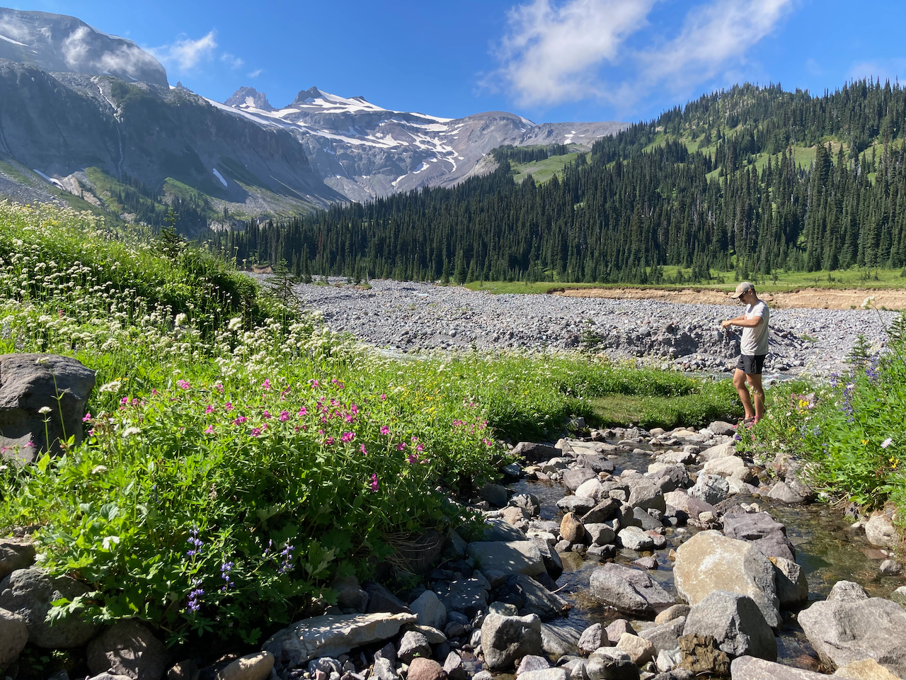
Just before slogging up the switchbacks, we got our first good glimpse of Rainier, although partly covered by clouds and many wildflowers.
The switchbacks weren't backbreaking, although they did get the heart pumping, there are not that many of them. Also, motivating us on the way up were better views of Rainier and scenic meadows across the valley on Goat Island Mountain.
It took us around three hours to make our way up to Summerland, which is a relatively slow pace but we were not in a rush. When we got up to camp I was excited to get set up and have everyone take a look around the area, and we had plenty of time to do that given that it was only 10:30 a.m.!
Summerland Group Shelter Camp
I have seen the group camp at Summerland before, as well as viewed a few pictures of the stone shelter online. It's even better, however, to come across it knowing it's your campsite!
A ranger greeted the first members of our group at the shelter and checked my permit when I arrived. This would be the first of many encounters we had with rangers as they seemed to almost hike and camp with our large group.
We unpacked slowly, ate some food, used the conveyor belt bathroom, and tried to get used to the new digs.
Water
The water source for Summerland is a stream that crosses the trail south of the camp. The water was clear and plentiful. It's a popular spot to take pictures, filter water, and hang out. The ranger was posted down at the creek, watching over us as we stepped over the dead sticks and branches—placed by the park to control traffic on the stream's edge—so we could filter water off the trail.
For the most part, she wasn't critical of our choices for filter locations but made comments about people sitting in the mud on the water's edge (as opposed to standing?) and asked my friend not to jump back and forth across the stream in the blocked-off area.
Finding Space
We had six tents and one hammock that needed to fit in the camp. I quickly found a few trees that satisfied my hammock needs, but finding space for all the tents was more difficult because the ground at the group site is sloped.
We fit two tents inside the shelter, and another was moved onto the flat surface in front of the shelter later. My brother barely fit his tent in a picturesque little space bordered by roots on the edge of camp.
Also, we saw a great flat spot close to camp that a group member selected giving us the necessary space to fit all the tents.
Surprisingly, that afternoon, the ranger came by informing us that spot wasn't part of the group camp! Despite it looking like a perfectly good spot to set up a tent. She was gracious enough to allow us to use the space for the night because we had already put a tent there but then proceeded to add signage and a log to block usage by future groups.
Passing the Time
Summerland sits on a knoll at the head of the valley, where the tree line thickens beneath a few hundred yards of subalpine meadow before the greenery turns into an alpine rockscape.
To the west, stepping out of the trees in camp, Mount Rainier is spectacular. We missed peak wildflowers by a week or two, but that hardly degrades the view.
North of camp, across the valley, is Goat Island Mountain. There is a green belt near the top of the ridge where the trees thin out that begs for wildlife. Walking up to the individual sites' bear pole (past the bathroom), there is an open area where my brother used his high-powered binoculars to look for elk or bears on Goat Island Mountain.
East is a look down the valley holding the trail from Fryingpan Creek and a glimpse of Tamanos Peak. If you walk out to the end of the individual sites you can find a small trail that gives you a mostly unobstructed view looking east from the head of the valley.
South of camp, the Wonderland continues up to Panhandle Gap. We spent hours looking south from the group site in our ultralight chairs, or on a plank fashioned into a bench.
This 'viewing area' faced the waterfalls of Upper Fryingpan Creek. We could see people trying to ford the creek, something we would be doing the next day. In the foreground was a meadow where we spotted a game trail and a few marmots. My brother sketched the vista.
Framed pleasingly between a few trees we played cribbage, sipped whiskey, laughed (I may have giggled), talked about gear, and waited for the last two members of our group to arrive.
Around 6:15 p.m. my sister and her boyfriend arrived. They set their tent up on the north side of the shelter, which wasn't quite big enough. After making food, it didn't take long for the sleepiness to set in as the sun went down.
I thought that we might hop on the Little Tahoma Trail for something to do with all the extra time we had (not to climb it but just to walk up somewhere new for a little while). However, when I located where the trail splits off from the Wonderland there was a NO Stomping the Meadows sign. Consequently, we dropped that plan.
Talking to a park ranger later she explained that is the Little Tahoma trail, but they don't want people walking across the meadow—making it some kind of secret route.
Day 2
Destination:
It was a calm night (despite the night terror that a group member suffered) with hardly a trace of wind. The moon rose late and was surprisingly bright.
Waking up just before 6:00 a.m., I noticed mostly clear skies. Clouds remained around Mount Rainier's cap and lower clouds had moved into the valley below us—making for some wonderful sunrise photos.
Early Bears Get the Worm
Originally, I was prepared to make coffee and chase down a few sunrise photos. My brother was out of his tent at the same time I left my hammock. He asked me, “Do you want to go look for bears?” This meant, did I want to go back to the place where we had used his binoculars the day before to scan the higher meadows of Goat Island Mountain? I accepted.
I stopped at the bathroom while my brother continued up to the grassy area near the individual site's bear pole. When I caught up to him he was already scanning the other side of the valley. It hadn’t been more than a few seconds of me standing next to him that he proclaimed he spotted one!
A black bear was cutting right across the center of the meadow on Goat Island Mountain, exactly where your eyes would expect to see wildlife! Without binoculars, it would have been practically impossible to identify the very small black dot as it was approximately a mile away from where we were standing. However, with the high-powered binoculars, we got a pretty good look at him.
Not content with just seeing one bear, Jordan continued scanning the area and spotted a second bear! It was moving in the opposite direction a few hundred yards up from the one seen first. After rounding up a few group members as they slowly emerged from their tents to come to take a look at the bears it was finally time to take some sunrise pictures and make some coffee.
Sunrise
Stepping out of the trees to the west of camp I set up a timelapse to hopefully capture the early sunbeams as they landed on Rainier. Below is that timelapse.
Those of us who awoke early were treated to all kinds of new colorful scenes as orange beams hit the surrounding cliffs and the sun passed behind clouds to the east.
The Hike
We moved casually that morning, at least I did, knowing that our hike was just over four miles and we wanted to spend plenty of time enjoying it. It was shaping up into a beautiful morning as we broke camp around 9:45 a.m.
The sunshine made for ample opportunities to stop and take more photos while we caught our breath. The first order of business was crossing Upper Fryingpan Creek. The bridge was reported out and some stated that crossing required a knee-high ford. Fortunately, this was not the case by the time we arrived because we were able to find a relatively, more or less, easy crossing.
Our next stop was the teal lake that sat just off the trail in the basin below Panhandle Gap, the Fryingpan Glaciers, and Meany Crest. Back in 2020 we backpacked middle of September, and because it was later in the summer the lake was larger. This time around the lake was noticeably smaller. Nonetheless, a few group members went for a swim!
Also, in 2020, it was windy and cold by the lake which shortened our break on its shore. This time, conversely, it was beautiful. There was very little wind and a lot of sunshine.
Panhandle Gap
Next, was the final push-up to Panhandle Gap. We encountered one snow field and a very awkward straddle over one remaining block of snow on the trail.
The cloud covering the cap of Rainier, which had been there since our arrival, finally lifted.
A few of us scrambled up the rocks to get a panorama of the whole area. We could even see cars heading up the road to Sunrise Visitor Center.
It took us nearly two hours to get up to Panhandle Gap! We had a large group and some members required more time, but we also stopped frequently to enjoy the scenery.
Subalpine Sanctity
Cresting Panhandle Gap and continuing south along the Wonderland brought our journey into a treasured section of trail along the Wonderland. From Panhandle Gap to the highest point on the Cowlitz Divide is a magical stretch of less traveled trail. Only hardy day hikers continue on past Panhandle from Fryingpan Creek. Likewise, the trek from Box Canyon to Indian Bar can be a full-day excursion. I’ve called it a backpackers paradise, where the backpacker truly reaps the rewards of traveling on the trail with a heavier pack on their back.
We crossed a few snowfields, which I didn’t quite expect, and their footing was surprisingly poor. Thankfully, we all had poles to help stabilize ourselves.
We stopped to filter water at one of the many clear streams crisscrossing the trail. Taking a break, my brother again pulled out his binoculars and we were able to just barely make out a few goats on the side of Banshee Peak.
We would have felt very alone except for the military plane that seemed to continually circle the mountain. A joke surfaced that they were looking for Angel, our active duty military member because he had left work early on Friday.
It was hot, and we had one last climb before the descent into Indian Bar. That last climb was difficult. We had spent a lot of time on the trail already and, without a breeze, the sun seemed to push us down the trail.
Here, our group split. Faced with such a daunting drop of elevation knees start to hurt, legs become sore, and the only cure is your own pace.
Descending to Indian Bar
Coming over Panhandle Gap, I was disappointed to see the entire valley of the Ohanapecosh covered in clouds! We still had marvelous views of the waterfalls far up the Ohanapecosh basin, more plentiful and larger than I remembered in 2020.
Looking down into Ohanapecosh Park, I came under the illusion that the clouds were leaving and that things were clearing up. It was not twenty minutes before it was no longer an illusion, but reality, that the clouds were clearing out! First, they moved out of Ohanapecosh Park to our left, revealing some beautiful views with the Cowlitz Chimneys as the backdrop.
Then, the whole valley, even the group site shelter was visible if you knew where to look.
It was so special that the clouds moved out at such an opportune time for us. Dropping further down into the subalpine environment offered us another surprise.
Wildflowers
Previously, we thought that we had missed the peak wildflowers by a week or two. This was certainly the case at Summerland. But, I recalled that when hiking the Enchantments last fall the larches hit the peak at different elevations at different times. Consequently, we missed the peak in one area but saw them peaking in other areas (depending on the elevation). Entering the higher meadows on the north side of the basin holding Indian Bar, we stumbled into a blanket of wildflowers.
I've never seen wildflowers like this before! And, in such an ideal spot. We took many photos. The wildflowers were on the entire slope even further down in the trees, but they were most picturesque in the wide open meadows.
Trail Erosion
Eventually, we left the trees and found flat ground for the first time in a long time. It was hard to believe that we had been on the trail for almost five hours! A large part of the trail on the north side of the Ohanapecosh River has washed away (I believe this year) due to large amounts of rain and snow. Cairns and arrows in the dirt pointed us down into the river bed to make it around the eroded areas.
Also, right on the trail in the river bed was large bear scat. The ranger also warned us that a bear the previous day was seen in site 4 at Indian Bar, and we would soon see for ourselves that he was still hanging around!
Indian Bar Group Shelter Site
Arriving at the Indian Bar Group Site was a cause for celebration. Being done hiking after five hours and thousands of feet of ascent and descent is exciting, but getting settled in at Indian Bar's Group Shelter makes it all the better.
The first order of business was to run up to use the restroom. Snapping a shot on the way down. Next, I submerged a beer in the creek that runs down near the shelter.
When I arrived at camp my brother wanted to find a place to cast a line into the Ohanapecosh. The prospects were slim, but it was something to do and who knows—maybe some fish had made it up the rapids!
Down where the group shelter trail splits off from the Wonderland an amazing little stream comes down from behind the shelter. This is the water source for the camp.
The view up the valley from in front of Indian Bar's group site shelter is lovely. We set up chairs, bear canisters, or sat on the ground. We broke out a few drinks, including my mostly cold beer (which I split with my Mom), so we could sit—with nowhere else to be—but in a beautiful and scenic place with family and friends.
We fit three tents inside the shelter, with my brother and I opting to sleep on the metal and wood bunks that hang from the walls. These are old, but if you sleep on the bottom bunks you can put small logs or rocks underneath that help to remove any doubts that it might not support you. I used my hammock bug net, tying a string around the top bunk, which gave me some defense against insects.
I slept great on the bunk with a small air mattress and some earplugs. The bunks were long (I'm 6'2") so my feet didn't hang off the end.
More Bears
Flashback to 2020, late in the evening, we watched an elk come over the hill to the north of the shelter. He was across the river, up on the ridge, and we saw him towards the top in the meadows where the trees start to thin out. Chase, my friend, was on that trip, and he was now on this trip returning to Indian Bar.
Naturally, he kept a watchful eye on that area as the whole group hung out in front of the shelter. To our surprise, he pointed to the meadow and with a focused stare said calmly,
"Oh, bear."
A small black bear was digging and rolling around on the slope about a quarter mile away. I grabbed my brother's binoculars and took a closer look. We all took turns looking at the little guy before I noticed he seemed preoccupied with looking west, stopping and holding very still now and then. Well, he eventually started making his way west, traversing the ridge, toward the meadow where we entered on the Wonderland trail earlier in the day. One of us notified the ranger and we thought that was it! However, not too long after, Chase saw a different bear in the same spot!
This one was much bigger and was a light brown or cinnamon color.
This bear was concerning given his size and the way he seemed to look across the valley at us. It appeared he was traveling over the same area, disappearing then reappearing in the same place multiple times. We kept an eye on him until it got too dark to see. That was the last we saw of it.
I saw a grizzly and her cubs in Grand Teton National Park when I was a teenager. Then, hiking in Canada with my wife (girlfriend at the time), we walked close to a black bear, but I have not seen that many bears in the wild until this trip when we saw four!
Water
I like to note where the water source is when I stay at a backcountry site, or where it is along the trail. This section of the Wonderland Trail has many opportunities to filter. You hardly go a mile without having the chance to fill up.
I noted Upper Fryingpan Creek, just past Summerland and about a mile below Panhandle Gap. Also, at this time of year, there are chances to filter at many streams south of the Panhandle Gap. There were at least six different streams that could have worked.
Finally, down at Indian Bar, there is a clear stream on the north side of the river and a perfect stream that comes down next to the group site trail.
Fog
Thick fog, mist, or clouds rolled into camp as soon as we laid down to sleep. We could hardly see the river and definitely could not see the bank on the other side. It made for a dark and ominous scene but I wasn't concerned. I was tired and was looking forward to sleeping in the warm, quiet, and protected shelter.
Day 3
Destination:
I slept well on the wooden bunk in the shelter. The wind stayed down for another night making the night calm. No wind, combined with the number of bodies in the shelter also kept it warm.
The mist was thick when I first woke up around 6:00 a.m. but I thought I noticed my visibility starting to improve.
My uncle was up and we made coffee. I put on a rain jacket because it was a little chilly but more so because the mist was thick and damp.
Remarkably, the mist was improving all the time! Slowly bringing our incredible views back but with different colors, lighting, and clouds.
Soon, a few of us were up and finding different angles and areas to capture the sunrise in its different stages.
Again, I wanted to capture a timelapse and took two videos of different lengths.
Our last day was our longest. Some members had long commutes back home, so we did not want to hike at a pace of one-and-a-quarter hours per mile (like the previous day). We wanted to leave earlier, shooting for an 8:30 a.m. start. But, a few things here and there while packing, taking pictures, and last-minute items pushed the start back to 8:45 a.m.
The delayed start was not a problem, and it felt wonderful to be out on the trail earlier to utilize what little shade we had going up the Cowlitz Divide.
The Hike
I knew the climb out of Indian Bar to the south (the way we were traveling) was not as difficult as the climb out on the north side. The trail is more gradual, and there are fewer—and smaller—steps. Climbing out of the valley the shelter became smaller but we were reacquainting ourselves with Mount Rainier!
It was a perfect morning. Cool temperatures made the hiking less difficult and the clear skies brought out brilliant green colors in the surrounding meadows.
Cowlitz Divide
In 2020, it was very smoky, so we didn't have great views on the Cowlitz Divide of the surrounding mountains. Now, in 2022, we had not reached the highest point on the Cowlitz Divide and we already walked straight into a well-positioned view of Mount Adams!
We enjoyed more wildflowers between the peak on the Cowlitz Divide and Indian Bar, a sight on the trail that was now commonplace.
Cresting the high point, I notified the people at the front of our hiking party of a ledge off the trail that afforded a nice area to stop to rest and have some food. We had not been on the trail long, but the climb out of Indian Bar was taxing and this was a convenient stop.
Right in front of us, in the middle of the vista is the Tatoosh Range. To the left, off in the distance, is Mount Adams. Only slightly visible is Mount Hood down in Oregon. Of course, to our right was our companion on the trip, Mount Rainier.
The trail has multiple ups-and-downs on the Cowlitz Divide with areas of flat and gradual trail. With a bit of a breeze and the sun out, it made for great hiking. Still, we welcomed more shade as the trees grew and multiplied and I noticed a few blueberries as the trail started to favor the eastern slope.
Down, Down, Down
We were descending steeply before hitting the Olallie Creek Camp trail junction. From here, I knew a series of switchbacks took us down the trail to Nickel Creek, and then we would be at Box Canyon.
The long day, and long descents, proved that I should have worn my new flexible boots a few more times before taking them on this trip. My feet were sore and now without views of the mountain, we were ready to get down to the road.
Despite the desire to finish our trip, the forest was enjoyable. The trees were large and provided a lot of shade.
Getting down to Nickel Creek, a very clear and full creek, we passed the ranger (whom we leapfrogged three to four times this day) that had been hiking the same itinerary.
We reached Box Canyon Trailhead around 1:30 p.m. hiking at a much faster pace than the day before. Triumphantly, we loaded up the cars and it again dawned on me that our trip was not over yet.
Water
Leaving Indian Bar, I informed the group there would not be a creek to get water from until Nickel Creek (0.8 miles from the end of our hike). This was incorrect. Although no water was available traversing the Cowlitz Divide, a few small creeks were not dry as we dropped off the Cowlitz Divide before Nickel Creek. None of the creeks were very appetizing but provided an opportunity to filter water.
Finally, Nickel Creek was large, with clear water. We did not filter water here because we were close to finishing our hike.
Getting Back Into the Park
Our trip ended on a sunny Sunday in August. This meant many people would be lining up to make it into the park at the Sunrise entrance and the middle of the day would see back-ups at the booth.
We approached the Sunrise Entrance just after 2:00 p.m. and read on the digital sign that the wait could be one to two hours. This was unwelcome news.
We had three cars down at Fryingpan Creek and were driving two up from Box Canyon. My brother decided that he wanted to jog the few miles into the park and drive them out. So, he recruited my cousin and sister's boyfriend to run it.
Half an hour or so after they started running we entered the park (we didn't get out of line even though they started their jog in) and had the Fryingpan Creek bridge in sight, but driving in the opposite direction was our companions who had reached the cars only moments before! In hindsight, we could not have predicted that the line would start moving quickly.
My brother remarked that the road was more uphill than he predicted and we noticed that there is zero shoulder on the road making it a pretty dangerous jog.
In the end, the traffic obstacle became more of a funny anecdote than anything seriously upsetting. We still made good time getting back to the house and began the process of unraveling our gear, sharing stories, and many pictures.