


Introduction
With my recent move back to the desert (La Quinta, CA) I wanted to chronicle a series of hikes where I provide the information that I sought out before the hike, or discovered later, because this information was what I needed to know.
I’m 25, in decent shape, usually hike alone (not always by preference), and like to plan a decent amount. If that’s relatable, I suggest continuing. The hikes I’m choosing are for slightly more experienced hikers with sometimes a little travel time, sometimes a lot of travel time.
When I talk about weather, finding trails, or trail stats these are the apps where I get that information from:
- I find hikes mostly using the AllTrails app.
- I use Maps 3D when I’m actually on the hike (love it)
- I use NOAA Radar or Weather Bug for weather
If you are interested in other hikes that can be reached from the Coachella Valley, below are some small posts, that may or may not be useful from last winter (some might just be a picture actually
- Bear Creek Oasis
- Bogert Trail to Murray Hill
- West Fork Trail – Indian Canyons
- Palm Springs Aerial Tramway
- Eisenhower Mountain
- Art Smith Trail
- Joshua Tree
- Bump & Grind
- Painted Canyon Trail
I need to add a disclaimer, that although I intend for my posts to be used as trip reports, or helpful guides, you are still hiking at your own risk. You should always carry the survival essentials, let others know your hiking/route plans, and favor caution.
Quick Stats for Hike 7
- Total Time: This excursion took ≈6 hours 15 minutes
- Date: February 26
- Driving Distance: ≈17 miles (from La Quinta)
- Hike: 6.40 miles, desc./asc. ≈3,600 ft., 5 hours 11 minutes, trailhead elevation 470 ft
- Expenses: Food, Gas
I thought it looked nearly perfect when I first saw the medium sized rock sitting on top of a larger pile of boulders. It would make a fantastic vantage point to stop and take in the surroundings. After a surprising difficult hike, it was energizing to see my (potential) destination. Before I set out that morning, I pondered my ability to hike the entire 9 miles—and 8,000 ft elevation gain—to the tram. Just over three miles in and pushing 3,500 ft in ascent, I knew that this hike was no joke. Regardless, what I really hoped, as I approached my small hill of boulders, was that is would allow me to see the snowy San Jacinto range further up.
No mystery about this hike. It's one of the most well known in the valley and, possibly, in SoCal. The potentially deadly Cactus-to-Clouds (Skyline) Trail that starts in the parking lot of the Palm Springs Art Museum.
I certainly don't have the hardened hiking muscles, or the logistics, to get to the tram. The weather, and the amount of snow that was still on the slopes, posed a different problem. What I did have, was a hunch that I could still find a destination that would offer a pretty spectacular view.
This hike goes uphill fast, as opposed to my previous hike that was long and not very steep, and I was looking forward to a more vertical challenge.
The star blocks the map label for 'Palm Springs', but also marks the trailhead location.
What's easy to take for granted, is the quick access to great hiking that the valley has to offer. This hike is unparalleled, in the area, for what it offers and it basically starts in downtown Palm Springs.
Doing the full hike to the tram is what I would consider a difficult adventure. Completing the museum hike (short section which I'll explain later) is too casual. This hike is the middle adventure. It has a destination with an inspiring view, doesn't take the entire day, and hikes beyond the crowded section of the trail.
Destination:
The Trailhead
My first concern after looking at the location of the trailhead was where I was going to park. Being downtown, there probably wasn't a big dirt lot to pull into. I found resources online quickly because the hike is so popular.
The first link I found quelled my concerns. The Hiking Guy has great articles on hikes in the area with loads of good information. I didn't read his complete Cactus to Clouds article but I found the part I needed.
“When you park, do not park in the Art Museum parking lot, or in the covered lot across the street, which has a 4 hour maximum time limit. Park on the street next to the garage and lot, which is free.”
There was plenty of street parking in the morning and when I arrived back in the middle of the day. The street parking offers way more shade than the art museum parking lot, anyway.
Picture taken from the edge of art museum parking lot looking up the street that I parked on.
The trailhead is very easy to find due to the large sign at the back of the art museum parking lot and the small size of the parking lot.
Art museum on the left (out of picture).
The start of the trail is straight towards the back (referencing the above picture), and the landscaping of a private road (that the trail crosses) can be seen cutting diagonally up on the hillside. There are a few signs at the trailhead.
The trail gets a lot of traffic, and volunteers have done a great job keeping it in good condition.
Like I mentioned, this trail can be deadly.
I knew I wouldn't have access to a bathroom or water at the trailhead, due to the early start, so I planned accordingly. Even if I started later in the day, I would bet that it's frowned upon, if not disallowed, to use the museum's utilities for this sole purpose.
I started the hike at 5:15 a.m. with no one else in sight. Despite being so close to the city it was still fairly quiet. I was looking forward to starting early so I would be able to watch the sunrise. I had overestimated how cold it was going to be (especially after the last hike) and knew I would be shedding clothing soon. Regardless, I buckled my backpack, and adjusted my hiking poles.
The moon was in its third quarter, but didn't provide quite enough light for the steep—and rocky—trail. I turned on my headlamp, pressed play on my recording gadgets, and started hiking.
The hike
The hike gains about 1,000 ft of elevation every mile, and the first part can be quite rocky.
I took this (not so awesome) picture when I was almost back to the museum. I hope you can see, not only the incline, but the absence of a nice smooth trail at the beginning of the hike.
I mentioned it was dark when I started the hike, and I soon realized that the correct trail route can be taken by following the white spray paint.
White dots can be seen to guide hikers along the trail to the picnic area.
The white dots were easy to spot, and quite useful due to the roughness of the trail. However, they only last until the picnic area.
There is a section at the beginning of the hike that got a little perplexing, even with the dots, and I actually ended up taking a different route on the way down (by accident).
At the top of the trail route (in red) it can be seen that the hike heads to the hikers left, up, then back down the right. In between the blue navigation indicator and the trail, if you look closely, there are two trail lines.
This is one of the steep, switchback cutting, sections that the sign was mentioning to not take.
That being said, it's difficult to distinguish one trail from the other.
Doing your best to follow the dots, and being slightly aware that this is an aspect of the trail, will remedy any confusion. After shedding a jacket, I continued to follow the dots while the trail became more straightforward and less rocky. I also noticed that it was beginning to get lighter.
I turned around to see the creeping red line of the sunrise. This is an important aspect of hiking to me. Having the chance to appreciate the sunrise, while many people are just waking up (or still asleep), constitutes a large part of the reward for waking up early.
Looking east down the Coachella Valley.
I paused for a second to take in what I could notice. The desert cities had a little dust in the air, that would remain throughout the day, and I began to hear more industrial noises. To my surprise, I heard quite a lot of birds mixed in with the sounds of the waking valley.
To my right (south) I noticed snow on the mountains above highway 74. Towards the top of the picture, Venus can be seen as a small spec of light. I could see Eisenhower Mountain's head in the distance, and just beyond that was La Quinta. I thought about a book that a roommate of mine had showed me recently. It has many images of La Quinta form the 1930s. It's strange to see what it used to be, and what it has become now, in the span of 90 for so years.
I noticed another object in the sky that was in between the moon and Venus, and hypothesized that it was a planet as well. I pulled up my SkyView Lite app to investigate.
Screenshot of phone while using SkyView Lite app. The phone is pointed at the sky and the animations of solar objects appear over the objects themselves.
Sure enough, the 'bright object' close to the moon was Jupiter. I also discovered that, although faint, even Saturn was still visible next to Venus. I continued on hoping that the alignment of the solar objects was a good omen.
Part of me thought that the white dots may go all the way to the top. That thought proved to be false when I reached the picnic area. This is the popular destination. However, it's still a pretty steep hike to this point.
Maps 3D was telling me that I had walked 0.77 mies (to the picnic area) and ascended 827 ft. Which can be a heck of a workout in the desert sun. It wasn't the heat of the day, thankfully, so I could enjoy the view a bit more.
At the trail junction, just above the picnic area, there was another hiking club volunteers sign along with some creepy lost items.
It was amazing how many sounds I could hear from down below. The mountain bounces the sounds around so well that I thought the noises were occurring on the trail, and not down in the city.
As I ascended, the sun eventually came up over the mountains, and I stopped to take a few photographs.
There wasn't that much to note in the next section of trail. I was feeling pretty tired, and was surprised how warm it was. When I saw the Rescue Call Box (I believe it was right around the second mile marker) I realized that it's really not very far from the city, but with the steep grade of the hike, and more extreme temperatures, I can see why there may be a need for one.
I was sweating a decent amount, underestimating the power of the sun, when I came across a welcomed sight. I was dragging a little, and thinking, "Wow, I wonder when I'll be stopping." And I checked my distance once or twice. After drudging with my head down for a couple tenths of a mile I came to the realization that the trail was going to be in the shade for a stretch!
The trail stays in the shade for longer than appears in the image.
This part of the trail (the slim & shady part) gets fairly steep as it climbs up and left (as seen from picture). However, the shade was such a welcomed surprise that I hardly noticed the incline. There were a couple areas that would be a great place to take a break. I want to hypothesize that this area started at about 2.3 miles into the trail.
There are a couple visible high points on the trail that the hiker is working towards. Once you hike up and out of the shaded area, there are two decent sized, flatter, areas to take in the view or rest.
Screenshot taken at 2.31 miles. Approximately 0.9 miles to final destination.
Both of the mentioned areas could have been places for me to end the hike, but I really wanted to see if I could get a better view of the San Jacinto Range. I hiked on.
It didn't lake long—after I left the second 'flat' area—before I came across, what I immediately recognized, as my destination. Yes, that little rock, on top of the boulder pile, near the center of the picture.
I could see the snowy mountains coming into view, and I knew that spot would be ideal.
The trail does a little bit of winding, but to my luck, it comes right up behind the rocky vantage point. This also looked like a common place for people to take breaks. There was even a Home Depot bucket, which I was afraid to open, and I couldn't read the writing that had worn away on the lid.
Maybe a toilet? There were a few flys in the area.
Standing near bucket, this is the backside of the boulder pile that I scrambled up.
The view was exactly what I had been looking for. I crawled up on the rock, immediately noticing that I was exposed to the wind, and situated my backpack carefully so it wouldn't slide off.
I took off my shirt and set it out to dry in the wind and sun. After zipping on the shell layer that I had stuffed into my backpack earlier, I opened up my water bottle for some fluids.
In 2 hours and 40 minutes I was able to hike 3.20 miles, ascending approximately 3,500 ft. My little boulder did not disappoint, either.
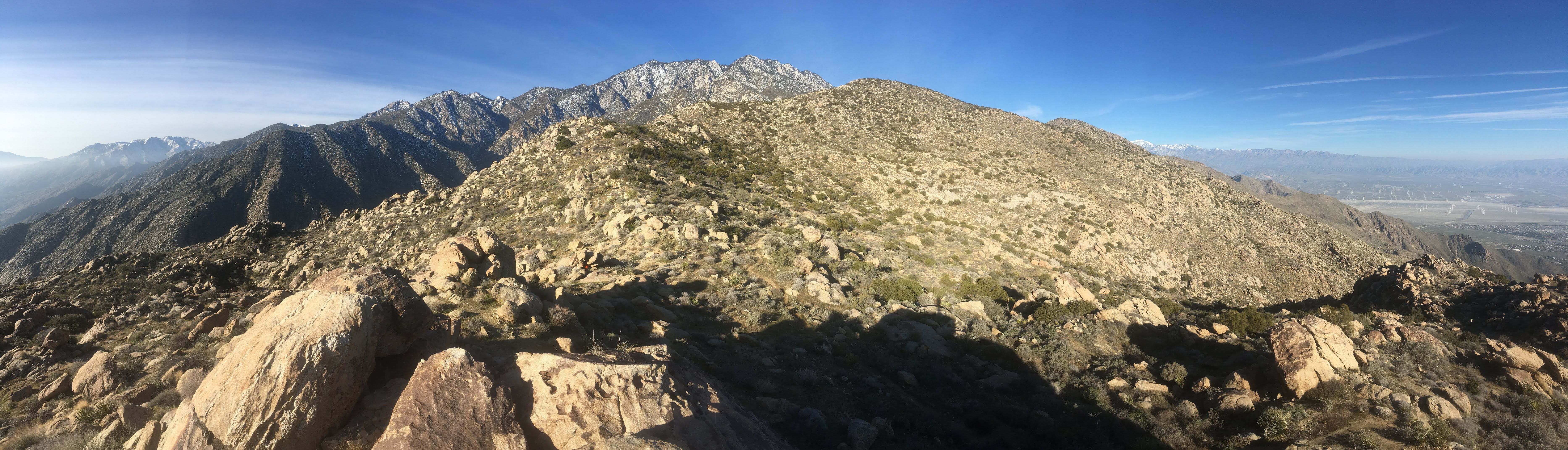
Approximate 180 degree panorama from turnaround point.
The trail continues on the yellow/greenish slope in front. Above that, there is the San Jacinto range (San Jacinto peak not visible). On the left side of the picture, there are beautiful snow dusted mountains surrounded by a dusty hue. More difficult to see, towards the right side along the ridge line, San Gorgonio's snowy top is visible. Click the image to get a better look.
Turning around, facing the valley was another solid view, but the haze was reflecting a lot of light around making it quite bright.
This hike is amazing, and not just in the 'Wow look at the view' way. You can reach elevation very quickly, there's a tram towards the top of it, it is maintained, the start location is downtown Palm Springs, and—now I'll mention it—the views are spectacular.
I stayed on the boulder for just short of half an hour before starting the steep decent. There were only a few things worthy of mention on the way down.
The first, I really appreciated the 'slim & shady' part of the hike, again.
The second, look at all the grass! The hills were green, especially in the lower elevations.
Third, I saw the biggest lizard munching on some flowers! There were other hikers approaching, and I told them about the lizard. The guy I told, apparently, sees giant lizards everyday, because he was not impressed.
Fourth, there were a lot of flowers that were beginning to grow at the lower elevations. Should be a pretty impressive bloom.
The trail became pretty crowded as I dropped below the popular picnic area. Despite that, descending this steep portion was more fun than the lower grade descent higher up. It was pretty warm, and I was sweating pretty good when I got back to my van. The hiking portion took 5 hours and 11 minutes van-to-van. It was still only 10:30 a.m., and that's why I chose the mild adventure instead of the full blown tram trip. I still had the majority of the day left, even if that included a nap in the afternoon.
A few things to note
- There is not that much shade on the hike, and the sun comes straight at you. It was definitely warmer than I expected.
- I drank more water on this hike than I did for my 14 mile hike in Joshua Tree. This hike required more work. I brought 56 fl. oz. and nearly drank all of it by the time I was back to the van.
- I had to dig a hole and do some 'business' off trail on this hike. Bathroom accessibility isn't the most ideal.
- There were many places to stop and get great views on this hike. I can easily see how 'summit fever' can get people to push beyond their limits. However, stopping short of the goal just means it can be tried again another time.
Thanks for visiting the site, and I hope this was entertaining, or helpful, in some way. Please, share any thoughts that you may have!