


Introduction
With my recent move back to the desert (La Quinta, CA) I wanted to chronicle a series of hikes where I provide the information that I sought out before the hike, or discovered later, because this information was what I needed to know.
I’m 25, in decent shape, usually hike alone (not always by preference), and like to plan a decent amount. If that’s relatable, I suggest continuing. The hikes I’m choosing are for slightly more experienced hikers with sometimes a little travel time, sometimes a lot of travel time.
When I talk about weather, finding trails, or trail stats these are the apps where I get that information from:
- I find hikes mostly using the AllTrails app.
- I use Maps 3D when I’m actually on the hike (love it)
- I use NOAA Radar or Weather Bug for weather
If you are interested in other hikes that can be reached from the Coachella Valley, below are some small posts, that may or may not be useful from last winter (some might just be a picture actually)
- Bear Creek Oasis
- Bogert Trail to Murray Hill
- West Fork Trail – Indian Canyons
- Palm Springs Aerial Tramway
- Eisenhower Mountain
- Art Smith Trail
- Joshua Tree
- Bump & Grind
- Painted Canyon Trail
I need to add a disclaimer, that although I intend for my posts to be used as trip reports, or helpful guides, you are still hiking at your own risk. You should always carry the survival essentials, let others know your hiking/route plans, and favor caution.
Quick Stats for Hike 9
- Total Time: This excursion took ≈10 hours
- Date: April 9
- Driving Distance: ≈50 miles (from La Quinta)
- Hike: 10.58 miles, desc./asc. ≈3, 588 ft., 7 hours 2 minutes, trailhead elevation 6,572 ft.
- Expenses: Food, Gas, One-Day Adventure Pass ($5)
Destination:
This hike was way more of an adventure than I planned. There was a good amount of snow on the ground and a wind storm came through that day (some gusts getting up-and-over 45 mph). I cannot count the amount of times I stopped, looked around, and thought, "Shit, where the hell is the trail?", before checking the map on my phone to confirm I was still trending in the right direction.
The last part of the ascent was even more of a beauty. The slope I chose to ascend, for the last couple hundred feet, was completely snow covered. There was no sign of any other footprints. I strapped on my crampons picked the best route I could see. When I got to the top of the ridge (Red Tahquitz Peak is on a ridge that extends to the northwest a little) I still had to traverse the ridge for another 15 minutes. Alas, I have gotten ahead of myself, and this will make more sense when I get into my actual hiking route.
I would not recommend this hike (unless you are prepared) with the amount of snow on the trails. I used my hiking poles, waterproof boots, YakTrax, crampons, and carried an ice axe for use with the crampons.
The hike becomes more than just a 'mild' adventure with the elements. However, if it were hiked in the summer, it would have more similarities (i.e. level of difficulty) to my previous hiking posts.
I need to acknowledge that this particular post may not be as useful as the other reports in this series because the conditions of the hike were highly dependent on an environment (and situation) that will likely change drastically depending on the time of season and climate. That being said, I will point you in the direction of useful information.
The 'Quick Stats' above are still fairly accurate. The description of getting a permit, where to buy parking permits, arriving at the trailhead, and going up Devil's Slide Trail will not vary as much as the rest of the report.Others may enjoy a quick peruse of the images showing the conditions and views. Everything in between will have the common theme of an attempt to stay on trail and move in the right direction. Enjoy!
The Trailhead
The gold star marks the approximate location of the trailhead. It’s ‘just above’ Idyllwild, CA.
The trailhead is called Humber Park, but is also known as Devil's Slide Trailhead. It is located northeast of Idyllwild, and is only 5-10 minutes from downtown.
It took 1 hour and 15 minutes to reach from La Quinta, and I was able to access it via Highway-74, then Highway-243. Due to the weather this winter, there was a washout on Highway-243 and it is closed at Mountain Center as of 4/9/2019 (which doesn't affect hikers coming from the valley).
The roads up to Idyllwild have a lot of curves, and can be quite narrow. The same is true all the way to the trailhead. Due to the fire, further down the slopes, there can be construction crews using one of the lanes.
Before hikers get to the trailhead, they will need to get a permit at the ranger station and a parking pass (unless they already have one).
Permits on Devil's Slide trail are limited on weekends between Memorial Day and Labor Day. On these days, the permits are ONLY given out inside. They cannot be filled out ahead of time.
The ranger station is on the way to the trailhead, and the parking pass can be bought at the Shell or Chevron stations for $5. The address for the ranger station is 54270 Pine Crest Ave, Idyllwild, CA 92549. There is a list posted outside the ranger station that lists vendors. What is nice about the pass is that it can be bought in advance (even for the daily) and then a person can scratch the day and month that they will be using it for.
I arrived at the ranger station when it was closed, but that was totally fine because everything one needs for the permit is outside at a nice booth (as well as other useful information).
Booth outside of Idyllwild Ranger Station.
The permit takes a minute, or two, to fill out. One copy is kept with hiker, the other goes in a slot. The booth has weather conditions, trail updates, where to buy parking passes, and much more information.
The description for this hike on AllTrails reads, "Get a wilderness permit. You are bound to come across a ranger on this trail (especially on the weekends). The Devil's Slide trail is overused and on a quota system, they will ask for it."
I had to make the tiny drive down to the Shell station to pick up a parking pass, but then continued past the ranger station and up to the Humber Park lot. The road is narrow and bumpy, but the signage is clear on the main turns with directions for "Humber Park Trailhead".
The trailhead parking lot has a decent amount of spots in it, and is in the shape of a loop.
Trail entrance with Lily Rock in background.
Bathrooms available.
Lots of room up here on a windy Tuesday morning!
The trailhead has areas to eat, bathrooms, and has a lot of shade. The trailhead wasn't very busy, and there were only a couple other cars there. It will certainly start to pick up soon, and parking on the weekends is, predictably, a different story.
The Hike
I mentioned earlier that I had brought extra snow gear with me for this hike. I was periodically checking a website, run by Jon King, that has San Jacinto Mountain trail reports. I knew there was still some snow up there, and that it would be a good opportunity to break out the YakTraxs, crampons, and ice axe.
My plan was the hike up Devil's Slide, then take the Caramba Trail to the PCT, before shooting off up Red Tahquitz. This would prove more difficult than imagined, but not until the Caramba Trail.
Devil’s Slide is popular and well maintained.
Good, and clear, flowing water on a few spots in the trail.
Devil's Slide is a great hiking trail. It climbs steadily up towards Saddle Junction. There are nice views at the Humber Park area, Suicide Rock, Lily Rock, and back at the valley to the west. It was quite windy, and there were a few snow patches towards the top of Devil's Slide, but I was able to make good time.
The colors correspond to different sections of the trail.
- Devil's Slide Trail = blue line
- Caramba Trail = green line
- PCT that I actually hiked on = dark red line
- full PCT route = faint red line
- Red Tahquitz off-shoot = yellow line
It was about a 2.4 mile hike up the Devil's Slide (blue) section. Saddle Junction is a beautiful area. When I got to the top I encountered quite a bit of snow on the ground, a few trail signs, and some sunshine.
Saddle Junction trail signs.
Snowy Caramba Trail.
At Saddle Junction, I came across a few signs. One pointed in the direction of Tahquitz Peak, Caramba, and PCT routes (there was also a sign back to Humber Park and Idyllwild on a tree behind me). I started following footprints, and the path, for the Caramba Trail. I was 'post-holing' a little, but was able to follow other footprints fairly well. The Caramba Trail is denoted by the green line on the below picture.
While on the Caramba Trail, the footprints stopped, and I started navigating on my own. It was a beautiful day—and area—but I found it hard to find the trail. At about 3 miles into my trip I found the second trail junction that would take me back towards the PCT.
Trail intersection on the Caramba trail. East, continues on the Caramba. South, moves towards Tahquitz Creek & the PCT. West, is the direction I came from. North, heads towards Willow Creek Trail.
I was happy to come across these signs. As one might be able to see, there weren't that many footprints (or hints) as to where I should be heading. At this point, I headed toward Tahquitz Peak, which would take me back to the PCT. In the picture below, the PCT is represented by a red line. The darker red line is the section that I traveled on. The lighter red line is the rest of the PCT. On the way out I took the Caramba Trail (green), but on the way back I stay on the PCT. It made the route more of a loop.
The Caramba Trail isn't a long section. However, in the snow, I could not see where the trail actually was. It was adventurous, but slightly dangerous.
There is a small stream that needs to be crossed inbetween Tahquitz Creek and the Caramba junction.
After I crossed this creek, I came across a beautiful section of the hike. I was beneath the Tahquitz ridge (which consists of both Tahquitz Peak and Red Tahquitz), but the trail was impossible to follow. What I did know, was that I needed to get to Tahquitz Creek, and when I did, I could follow that up to the PCT.
Tahquitz Creek with the Tahquitz ridge in the background.
As I followed the creek up towards the PCT, I came to the conclusion that I was making my own trail through the snow now. There was a discrepancy between where the trail was on my Maps 3D, and where I was, all in relation to the creek. I had to use more energy than I would have liked to ascend back up to the PCT. In my colored map image, I finally made it back to the PCT where the green line meets the thick red line (not Saddle Junction). I needed to take a break.
The footprints that are seen in the shade are the ‘PCT’
The footprints in the snow (difficult to see) represent the PCT. They are the functional PCT. The actual PCT may not be right here. The area around Tahquitz Peak had many trails with footprints. Some were on the PCT, some went off then traversed back on. I only saw one PCT marker because the rest are buried in the snow. This made for some energy intensive ascents, or descents, back to the footprints that best followed where the PCT is supposed to be.
DUE TO MOUNTAIN FIRE FOREST CLOSED BEYOND THIS POINT”
The above sign was located where the PCT crosses Tahquitz Creek, and it has to be inaccurate because this route is definitely open, and I have not read about (or saw) restrictions for the PCT in this area.
Regardless, it felt good to be following footprints through the snow again. I was on the PCT, and would stay on it until I veered off and went up Red Tahquitz. I passed a few 'through hikers' (some wearing shorts) who mostly sported microspikes. I stopped to talk to a few of them about trail conditions. I was now on the PCT between the yellow and green lines.
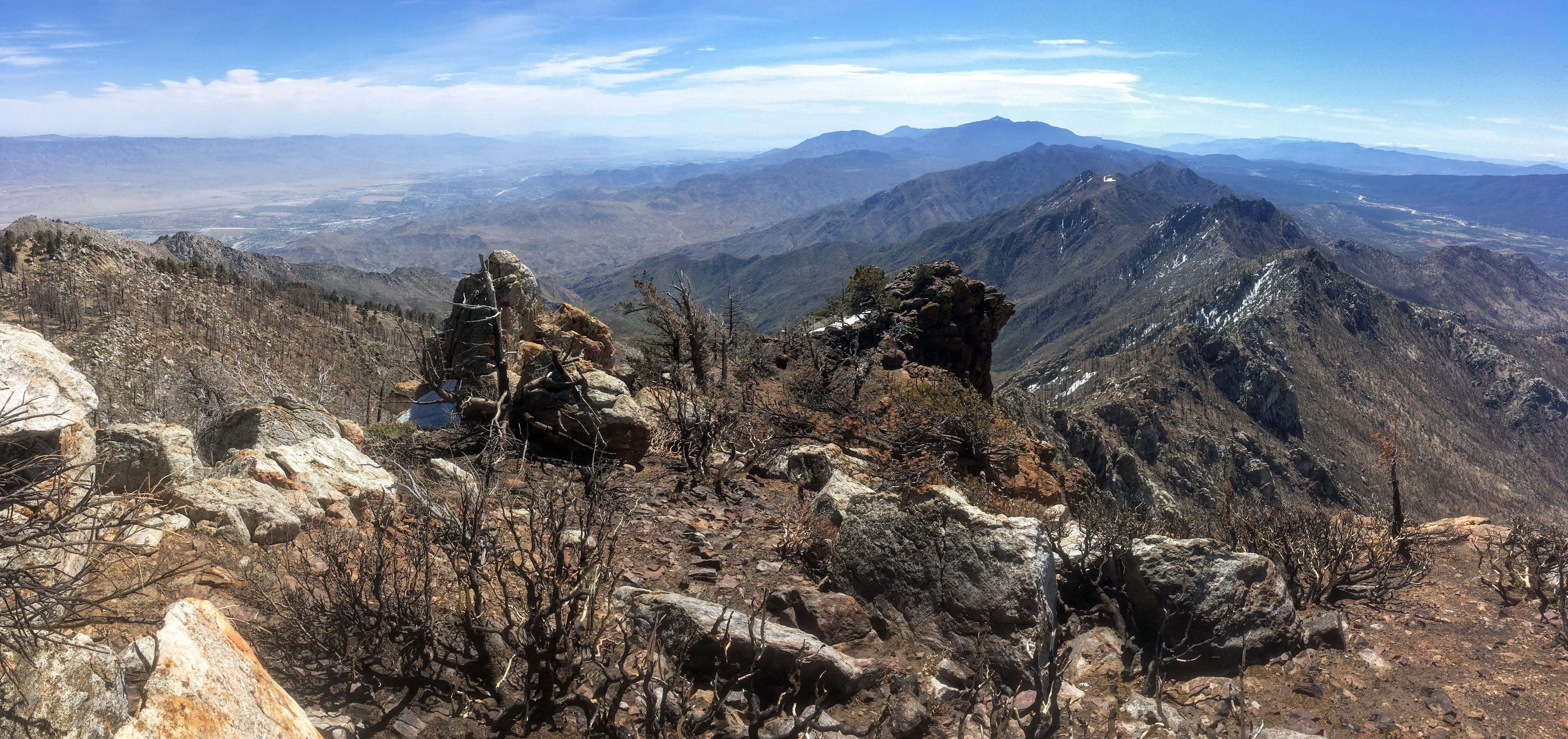
The ridge had a little bit of a slope, but not enough to warrant extreme caution. The snow on the ground surrounded the pines, and the trail was angled to look over towards Saddle Junction and across the San Jacinto range north to San Jacinto Peak.
Photo taken from the PCT (elevation approx. 8,300 ft). In the distance a few peaks can be seen. Marion Mountain, Jean Peak, and San Jacinto peak to name a few.
Now on the PCT, I was looking for the route up to Red Tahquitz. Two issues were at play. The first, I didn't actually know where Red Tahquitz was (I was merely inferring). Two, the slope was covered in fairly deep snow, with no sign of tracks. However, what I did have going for me was that I had crampons, an ice axe, and only about three hundred feet left to ascend.
The PCT climbed up slightly to a plateau that was more exposed to the sun. From here, I decided, the terrain was as good as it was going to get to ascend. I would realize later that I should have continued for another ten minutes on the trail (south).
I started to traverse the slope in the snow (a foot or two deep as far as I could tell) and it was icy in a few of the shady spots, so I was able to test out my crampon abilities. In other areas I was post holing. The grade become steep but I continued to work towards, what I believed to be, the top.
Snow became thinner towards the top of the trees.
The snow wasn't deep enough for tree wells to be a big issue, but the concept crossed my mind in a few areas as I was free wheeling.
It took quite a bit of work to get up the slope in the snow, and when I reached the top I realized that I merely hit the top of the ridge-line, as opposed to where Red Tahquitz actually is!
There are two points on top of the ridge where the yellow line is drawn. One of the points is Red Tahquitz, and the other is where I first made it to the top of the ridge. It provided a gorgeous view, but I still needed to traverse the ridge for another 10-15 minutes or so.
Gorgeous ridge-line with scars from fire.
I believe it was the Cranston fire in summer of 2018 that has done all the damage that can be seen. Where I first ascended, the fire damage was minimal, but towards the Red Tahquitz part of the ridge all of the trees were charred. The wind storm that day added to the situation, too.
I took off my crampons at the summit, because it was dirt and rock. I tried to fight the wind as I stood at the top for a few pictures. It had taken me about 3 hours and 51 minutes to reach this spot.
It was too windy at the top to stop for food and a break. I descended the east side of the ridge for less than 100 ft. and found a nice spot.
The fire damage was prevalent on this side as well.
I sat by a few cut logs out of the wind.
Burned trees with San Jacinto peak in distance.
I took a twenty minute break, and had already planned a different descending route back to the PCT than the one I came up on. This route had less snow, but still warranted a descent climbing grade. The descending route it the yellow line to the bottom left of the "Red Tahquitz" dot.
There was still snow, so I couldn't make out a trail on ground, but for the most part I was hopping along the dry rocks.
Viewpoint looking down the slope in the direction of the PCT.
I knew that if I followed this slope down I would come across the tracks for the PCT. Sure enough, after some careful stepping, I found the tracks that I was looking for. I turned back up the slope to get a picture of where I should have ascended (and where I had just descended).
Picture of slope where I descended from Red Tahquitz.
The picture doesn't say a whole lot, but I'll point out a few things. The slope is between a rocky point up to the left (east) and the Tahquitz ridge to the right (west). Looking at the screenshot with colored trail lines can also give context to where the better route was. Granted, this was done in the snow, so there is likely a better trail already on the mountain.
Once I was back to the PCT there was nothing but grunt work on the way back. The snow was melting, so my steps were sliding. It became a little bit of a trudge. I mentioned previously that the footprints didn't follow exactly where the PCT was. They followed whatever route the previous footprints had made. Twice I found myself following footprints that had to navigate back to a spot closer to where the PCT was thought to be.
I did not take the Caramba Trail on the way back (for obvious reasons) and elected to stay on the PCT until Saddle Junction. The hike back was fairly uneventful. It remained quite windy, and I talked to a few more hikers. I had a pretty good grip on the area by that point, and once I got back on Devil's Slide it was smooth sailing back down to the van.
I saw a good amount of people on the Devil's Slide Trail while descending and there were even more in the parking lot when I returned. I was very excited to get my boots off and take a rest after this hike. It took me about an hour less on the descent (3 hours) making the total hike time just about 7 hours.
This hike was a precursor of things to come. I'll be returning to the same trailhead soon to head up San Jacinto Peak, and complete the hiking series!
A Few Things to Note
- There was flowing water on the hike, but that will not always be the case.
- There are bears that sometimes wander around this area.
- Weather and trail conditions can change quickly. Check out the ranger station site, or www.sanjacjon.com for trail updates.
- There is a bathroom at the trailhead.
- Hiking permits are limited on the weekends for this trail between Memorial Day and Labor Day. Permits must be picked up inside the station.
- Parking pass required.
Thanks for visiting the site, and I hope this was entertaining, or helpful, in some way. Please, share any thoughts that you may have!