


Introduction
The Mount Margaret backcountry sits above Spirit Lake in the Gifford Pinchot National Forest. Two trails create a loop, connected by the Johnston Observatory to the west of the backcountry and the Norway Pass trailhead on the east side.
The northern part of the loop is the Lakes Trail, visiting a handful of mountain lakes surrounded by rocky mountains still recovering from the Mt. St. Helens eruption 41 years ago.
Last July, I did one night on the lakes trail before spending the second night at Dome Camp.
The southern trail of the loop is the Boundary Trail. Hiking along the Boundary Trail, one can see a magnified Mt. St. Helens, Spirit Lake, wildflowers, mountain goats, and an array of other mountains, including Mt. Rainier, Mt. Adams, Goat Rocks, and Mt. Hood.
Furthermore, the recovery efforts in the area make it so the backcountry sites are spread out, and only one permit is issued per night. This makes for an intimate experience.
Regardless of my efforts, it isn't easy to put sufficient words to the special geographical, geological, and ecological landscape. It's just a special place.
This report describes a one-night trip that I took with family in August, staying at the popular Bear Camp and experiencing many of the wonderful and challenging aspects of the backcountry.
Overview
- One night (Aug 14-15, 2021)
- Total Mileage: ~8.6 miles
- Trailhead: Norway Pass Trailhead (Northwest Forest Pass)
- Permits/Fees: Backpacking permit cost: $6/site/night
- Camps: Bear Camp
Day 1
Destination:
The Boundary Trail in Mount Margaret is exposed to the wind and sun. Consequently, the "Excessive Heatwave" warning, combined with a "Red Flag Warning," and in conjunction with haze from forest fires, added to the stress level before our hike in.
Nonetheless, we left the Puget Sound area around 7:00 a.m. before driving three hours to Norway Pass Trailhead.
The road in was better approaching the trailhead from the south (NF-99 then onto NF-26) in comparison to approaching from the north. The road has been repaved in a few spots and other depressions were manageable.
However, both require navigation potholes and a rough road.
My good friend, Chase, ran the Bigfoot200 race that started south of Mt. St. Helens on the day before our hike. We were excited to see him on the trail (mile 1 for us, mile 64 for him) but forgot about the aid station that was to be set up in the Norway Pass trailhead parking lot!
Somehow, we grabbed one of the few spots left, which also was in the shade. There are restrooms at the trailhead and pottable water. The water can draw with a crank pump. We didn't use it until our return on Sunday (it was refreshing how cold the water was).
We ate lunch, geared up, and left the trailhead around 10:30 a.m.
The Hike
The first 1.5 miles of the trail are exposed and can feel steep. Also, this section of the trail climbs steadily, offering a few areas to take shelter in the shade on a maintained and well-traveled trail.
If it's clear, you get views of Mt. Rainier and Mt. Adams, but you have to press on to Norway Pass to see Mt. St. Helens.
Despite the sweltering summer, there was still a snow patch after the initial climb. This part of the trail is shaded in the late morning/midday as the trail wraps around to the north side of the mountain ridge you're ascending. We stopped for a moment, but not for too long because the flies and bugs were on us.
They were relentless for almost the whole day. Practically every time we stopped, we applied bug spray and spent our resting time pacing and swatting to keep them off. As a result, we all smelled of sweat, bug spray, and sunscreen.
Photo Credit to Karen Retz
We, of course, took a break at the Independence Trail junction because it was our first view of Mt. St. Helens with Spirit Lake in the foreground. Coincidently, it's about two miles into the junction, which was about halfway for our hike that day.
The mountain and surrounding areas were all hazier than we thought they'd be. However, the optimistic side of our minds maintained that tomorrow (and that evening) would be better, and the haze would clear away.
After the trail junction, there's a section that's narrow and slightly overgrown. It's not a long section, but you end up pushing past a few branches. This overgrown section is just before the sketchiest part of this trail section.
Last year, hiking the same route, I wrote:
We didn't have that much trouble with the washout, but there is ~15 ft. of exposure to a lower trail that some other hikers have bushwacked that didn't want to risk the small traverse.
It's difficult to say if ~15 ft. is enough of an estimate. It certainly feels like more when you're looking at it. We took it very slowly, checking our footing and not trusting the rock too much. Thankfully, it's a very short stretch of trail.
We pressed on up to Bear Pass, stopping a few times to rest and look at the smoky base of Mt. Adams.
Turning away from Adams, we began the long traverse across the ridge to Bear Camp. The trail here is skinny and can be dangerous if you were to tumble down the hill. Although, the thought rarely crosses your mind because the views are marvelous.
Not more than half a mile beyond Bear Pass is a ridge that provides some shade and views of Mt. Rainier to the north. This part of the trail also had service. But, I didn't test how well the service worked.
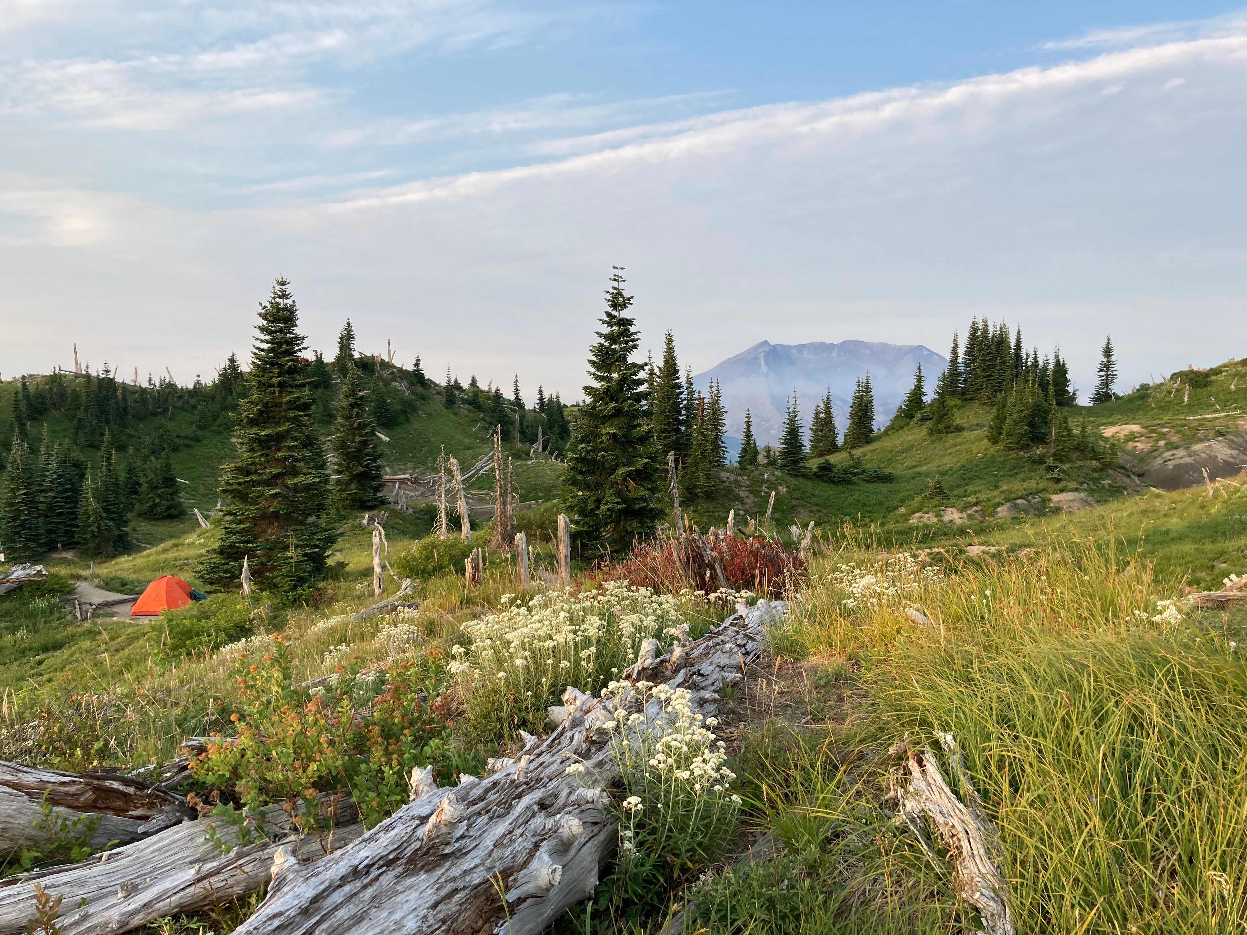
Looking down off the ridge, in the direction of Mt. Rainier, one could see Grizzly Lake below. After the relatively flat ridge, we began our final ascent up to Bear Camp. Not long after our stop on the ridge, the wildflowers began to really appear.
Photo Credit to Karen Retz
It was pretty hot, and we were tired by this point, but it was hard not to notice the colors lifting us into the special subalpine environment we found ourselves in.
Photo Credit to Karen Retz
After one last bend in the trail, at ~4 miles, we descended toward Bear Camp, making stops to take pictures of the slopes forming a stadium of greenery, once again with wildflowers in reach.
Photo Credit to Karen Retz
We spent 3.5 miles on the trail, arriving in Bear Camp just after 2 p.m. Did I mention it was hot?
Water
The only water source on the Boundary Trail was what was left at Bear Camp. A small trickle crossed underneath the trail, surprisingly clear, that a few hikers were filtering from.
The stream close to the "Bear Camp" was quite dry, and the water wasn't moving much. However, about 25 yards past the sign—if being quiet—you could hear some moving water, and there was a small boot path that split off to a part of the runoff that was moving.
Additionally, closer to the first tent pad, another boot path led down to the stream and had larger pools and more moving water. Additionally, two snow patches were visible from the second water filtering spot helping to keep the water flowing.
To reiterate, this has been a scorching summer. Furthermore, the stream is seasonal, so I was worried before the trip. Consequently, I was delighted to hear there was still some running water.
Bear Camp
Bear Camp is arguably the best camp in the area. Last year, we hiked past Bear Camp, and there was still a few snow patches, a cold stream with clear and fresh water. Coming down that year, we talked to a group in the parking lot that recounted a previous trip where they visited multiple camps in the area. Now, they only go to Bear Camp. This year, the water wasn't as plentiful, but it had all the other perks.
Photo Credit Karen Retz
It has a view of the upper part of Mt. St. Helens from both tent pads. The camp area sits on a saddle in the ridge that drops off not far beyond the second tent pad to the rocky cliffs that fall into the lakes are of the backcountry.
The first tent pad is in a nice spot, but you come to the second tent pad by continuing over a small hill. A clean pad, with a few dead logs laid down off to one side, with wildflowers growing a few feet above the pad at the apex of the hill. Quickly after noticing the tent pad, if the weather is fair, your eye catches Mt. Rainier, placed on top of the Cascade Mountains to the north.
Looking to the northeast, one can also see the raised ridge of Goat Rocks. But don't forget to turn around because 180 degrees behind your current view of Rainier is the top of St. Helens. To the left and right are rich green slopes and miniature pines resulting from the elevation at 5,000 ft.
I took about a hundred pictures of the area, looking north as the smoke cleared over our stay in the camp. We walked down a path 50-yards beyond the second tent pad, and I was startled by a herd of goats! We watched 8-10 of them on an adjacent ridge! They became regular visitors through our stay at the camp. In the evening, singletons were up on the slope to the west, and in the morning, they were down on a lower bluff and across the way to the east.
Photo Credit Karen Retz
Bear Camp's beauty comes at a price. It can be very windy. I was keen on this fact and tried to prepare everyone for a windy night. And, a few times, the wind picked up in the after, but it never got windy!
It was so hot, I slept mostly outside my sleeping bag and never woke up due to a gust of wind (as far as I knew). I was pleasantly astonished.
To conclude, Bear Camp has incredible views, nice tent pad areas, a pit toilet, water, and is ~4 miles from the trailhead. I was grateful for our stay at the camp.
Day 2: Bear Camp to Norway Pass Trailhead
Destination:
The second day I was eager to get up, make coffee, and watch the sunrise. There was certainly less haze, and it cleared out even more as the morning went on.
We caught a red sunrise over Goat Rocks. Watching the haze slowly clear away was energizing, and all the colors and views come into focus. I retook many of the pictures that I captured the previous day!
Photo Credit to Karen Retz
We left camp just after nine o'clock with a very similar trail ahead of us, just in reverse. Because it was mostly the same trail, I won't recount the same information from the first day. I will, however, note that it felt hotter on the second day because there was less coverage from the smoke.
Photo Credit to Karen Retz
Also, we went up to Bear Pass, a short climb off of the main trail to catch views of all the mountains one last time (including the hazy base of Mt. Hood to the south).
We all seemed to feel pretty tired, even though it was a one-night trip. The trailhead was quiet, per its usual activity, when we arrived around noon. We used the facilities before driving out the same way we came in. It was a trip that packed a lot of memories into a short amount of time.
Finally, we stopped in Morton at Timber Patch Brewing on the drive home for a beer and ordered some pizza from the Mountain View Wood Fired Pizza truck parked outside.