


Introduction
I've backpacked the East and North sides of the Wonderland Trail twice. I've backpacked the West side once, and I've done a one-night trip to Devil's Dream from Longmire. The missing piece of the 93-mile trail circumventing Mount Rainier, as far as my boots were concerned, was the south side of the Wonderland from Longmire to Box Canyon Trailhead.
The south side lacks the draw of other sections of the Wonderland. It doesn't have iconic backcountry camps or stretches of trail only accessible to backpackers. In fact, the best stretch of the Wonderland on the south side is the stretch alongside Reflection Lakes, where you'll stop to allow others to take a group photo, or side step a tripod or two. Therefore, it was not surprising that I had not made time in the past to walk this part of the trail.
That said, there is a beautiful camp on the south side of the park that's not on the Wonderland Trail: Snow Lake. Looking at a map, I saw an opportunity to hike the south side and get the best of both worlds. I would complete the south side of the Wonderland and camp at a desirable, worthy site.
This trip report is about a late-season, one-night trip I took with my Uncle and Mom. We enjoyed unexpectedly great weather, a spacious and private campsite, beautiful views of Mount Rainier, and a perfect late-season trip on the Wonderland Trail's south side.
Getting a Permit
We got shut out this year in Washington's two main backpacking lotteries. I apply for the Wonderland Early Access Lottery and the Enchantments Lottery every year. I encourage people I typically backpack with to do the same. Despite the numbers, no one was awarded a permit for either area.
It's hard, if not impossible, to build longer itineraries on the Wonderland if you miss the early access lottery, but there are a lot of opportunities for one or two-night backpacking trips when the permits open up in April.
I had hoped to backpack through the central Cascades this summer, but didn't have the time to take the longer trip. Fortunately, the south side of the Wonderland can be accomplished in one night. Despite missing the Wonderland Early Access Lottery, I was able to log in to recreation.gov in April and grab a September 7 (Sunday) one-night permit for Snow Lake Camp.
With the permit secured, there was one big piece left to figure out, and that was the car shuttle.
Car Shuttle
The south side of Mount Rainier National Park has Longmire, Paradise, and two entrances/exits. Visitors can exit or enter from the southeast or southwest, providing options for car shuttling.
Unlike 2024, there would be no timed entry for the Paradise corridor (south side) of Rainier due to ongoing construction throughout the summer. The MORA website listed times, days, and what to expect from the construction. Throughout the summer, trip reports rolled in stating the long lines to enter at Longmire, construction delays, and limited parking because of closed parking lots or parking lots used to store construction equipment.
All that information was noted in our trip itinerary, but I wasn't concerned about it because we had a plan.
First, we would enter on a Sunday, and construction would not occur on weekends. Second, we would enter and exit from the Stevens Canyon entrance (southeast corner) to avoid crowds.
I decided we would hike from east to west to avoid the long climb from Longmire to Reflection Lakes. Consequently, we'd start at Box Canyon and end at Longmire. For the best car shuttle, we needed three cars:
- First, drive a car to Longmire. This car would be our finish car.
- Then, drop a car (with our heavier backpacking gear) near Louise Lake, where we would exit the Wonderland and head to Snow Lake Trailhead
- Finally, drive a car to Box Canyon, where we would start our hike
Having a car in the middle (near Louise Lake) would allow us to hike light because we only needed our backpacking gear for the short 1 mile to Snow Lake. We did not need our backpacking gear for the 6-7 mile stretches on the Wonderland. It was a good plan.
Construction
The week before the trip, my Uncle sent me a note that SR-123, the road on the east side of the park we planned to use to enter at Stevens Canyon, would be closed for repaving. Now, we needed to enter and exit at Longmire.
There is actually a little more to the original car shuttle plan. The original car shuttle plan allowed me to exit at Stevens Canyon and head out east on US-12 over White Pass back to Spokane. The rest of the group could make it home, taking the less crowded and faster route on SR-123 to SR-410. The construction closure caused a series of changes:
- My mom would drop us off at Box Canyon and meet us at Louise Lake, so no car would be left at Box Canyon. She'd do a short hike at Paradise before meeting us to backpack up to Snow Lake after we walked Stevens Canyon.
- We would park two cars at Longmire. I could still exit at Stevens Canyon and make it to US-12, driving south on SR-123, and the rest of the group would exit heading west at Longmire.
Unfortunately, this meant we would have to deal with potential crowds at Longmire. To avoid the crowds, we would drive into the park the day before and drop the two cars at Longmire so we didn't have to deal with the parking in the morning.
Day 1 [Part I]: Box Canyon to Snow and Bench Lake Trailhead
Destination:
Getting Started
The week of our trip, the Wildcat Fire erupted just northeast of the park. Most of the backpacking trips I've been on in September have either been smoky or threatened by smoke. Air Quality Index readings two nights before our trip were well into the 200s, meaning we likely wouldn't go if the AQI didn't improve.
Thankfully, maybe, the weather was changing, and a system was coming through which we hoped would push the smoke out and help with the fire.
The AQI improved the day before our trip, but the weather system coming through was threatening some nasty weather. Checking my phone around 9 P.M. on September 6, the night before our trip, I saw what seemed like hundreds of lightning strikes around Mount Rainier. It was pouring. Mount Rainier received 1-2 inches of rain that night. It was a full-on storm. Nonetheless, we were going to take our chances on Sunday, September 7.
Due to inclement weather, we decided dropping two cars at Longmire the day before was unnecessary. Hopefully, fewer people would be heading to the park if the weather was poor. We still wanted to get there early, so we left the house around 6 A.M., planning to meet at the Longmire WIC just after 8 A.M.
Our predictions were correct, and there was plenty of parking at the Longmire WIC. Furthermore, we cruised right into the park. The early start, late season, and rain likely helped contribute to our not having to wait to get into the park.
We left two cars at Longmire for the next day and piled into one car to drive to Box Canyon to get started.
Box Canyon to Maple Creek Camp
It was quiet in the park, and thick fog made us drive a little more cautiously than normal. We pulled into the Box Canyon parking lot, put our day packs on, leaving our heavier packs and gear in the car. My mom was heading up to hike to Paradise while we did the six-ish miles to our rendezvous.
Earlier, as we drove from Louise Lake past Snow and Bench Lake Trailhead, we realized the distance between where the hiker comes off the Wonderland to Snow and Bench Lake Trailhead wasn't very far. Furthermore, walking the road didn't look dangerous. We decided to walk the road to the trailhead to meet my mom instead of meeting her at one of the turn-offs by Louise Lake.
We've started and ended hikes at the Box Canyon trailhead before. It has a place to use the bathroom, and we've never had issues finding parking. However, I've never walked south from the parking lot!
We stopped to take a look at "the box canyon", but quickly took the wrong trail before crossing the road. The trail goes over the road, not across it.
It was a little wet, but protected by trees. The trail was also soft, easy to follow, and quiet, except for our conversation, which was lively in the morning at the start.
The cool weather, terrain, car shuttle, and water sources meant filtering water wouldn't be a problem. We would have the opportunity to get water about every two miles:
- Maple Creek Camp water source
- Martha Falls (Unicorn Creek)
- Car shuttle
The majority of the hike was down, level, or slightly uphill. We didn't strain ourselves for most of the first section. The only concern, or thing on my mind before we climbed out of the valley after Martha Falls, was the landslide that washed out the trail a couple of years ago.
Maple Creek Camp
We came up on Maple Creek after about 2.5 miles of hiking from Box Canyon. I like to explore any camp I haven't stayed in to make mental notes about the sites, area, etc.
A group of girls was packing up from the night before. I asked them how the previous night went, knowing about the lightning storm and the large amount of rain that fell. They said it was crazy, and frankly, a bit terrifying.
We observed, on the trail, long shallow gashes caused by water rushing down the trail the night before, washing away pine needles and dirt. It was evidence that the storm dropped a lot of water.
Maple Creek was small, with a few nice sites offering some privacy. The water source was clear and reliable this late in the season. We stopped to filter some water and then navigated the mess of a crossing.
Remnants of old bridges are scattered around other downed logs. The path across is a zig-zagging mess with some sticks and rocks to help guide the hiker. Despite the mess, it's all mostly harmless, and we found the trail on the other side.
Bees
On our way to the slide area, we passed a group walking in the opposite direction who warned us about a hive with a few aggressive bees just off the trail. They had been stung a couple of times. I've never worried about bees while backpacking; there's always been other, more important concerns.
The park service had recently cleaned up the Stevens Creek trail area of the Wonderland. The bushes had all been cut back, away from the trail. Normally, the branches and wet brush would stick out and rub against hikers on the trail. Instead, we had a very clear path. Consequently, I thought it would be easy to spot any bees off the trail if we kept our eyes open.
Wrong. Not far from the slide area, without seeing or hearing any bees, I felt a sharp pain in my skin near my left achilles, just above the top of my boots. After a quick yell, I began hopping and running, trying to swat the bee off my sock and get down the trail quickly. It can be dangerous to run from bees in a panic because of the potential for tripping or falling. Thankfully, the trail was relatively flat, and no bees were in pursuit.
After getting a tenth or so of a mile away, I stopped to wait for my uncle. He was trailing me slightly before I was stung and was able to back off after I was stung to avoid the same fate. Once the bees calmed down, he ran past the hive and avoided a sting. Unfortunately, his water bottle fell out of his pack, so he had to, again, wait for the bees to calm down and retrieve it.
Not far before I was stung, we had found a headlamp just off the trail. My uncle deduced, correctly, that it likely belonged to the group we passed, possibly running after they passed the hive. Although correct, the clue didn't help prevent any stings in our group.
The sting was bothersome, despite going through my sock. If I had other gear, I probably would have put long pants on (I was in shorts) to prevent the bees from finding skin. I carry items in my first aid kit for stings or bites, but didn't use them till later at camp. The bee encounter was a bit of excitement, but then we came upon the slide area, so it was time to navigate a new situation.
Stevens Canyon Slide
The slide occurred either last year (2024) or in 2023, and a detour was set up that went down to the Stevens Creek rock bed, continuing up the wash area before climbing up a talus field to find the Wonderland again.
I read that the reroute added half an hour to the hike, so my uncle and I were going to time it took for us to get off and back on the Wonderland.
The reroute was easy to follow, but it was steep going down to the creek level and then back up. Thankfully, we didn't have our large packs. Coming back up from the creek was through a talus field, also steep, but the fog and cool temperature made it less difficult.
After climbing back up to the Wonderland, we checked the time, and the reroute took maybe 11 minutes, so the comment I read had exaggerated quite a bit. That said, the route was steep, and depending on hiking skills or level of fitness, it may take longer.
I've read in guidebooks that this stretch of the Wonderland has had washouts and slide problems before, and it will likely continue to happen.
Martha Falls
The trail was simple. Small increase in grade to Martha Falls, followed by a steeper climb out of the canyon to near Louise Lake. We stopped at Martha Falls to take a few pictures and filter water before the large climb of the day.
After a short break, it was time to start climbing. We had over 1,000 ft. elevation gain in about 1.5 miles, but the trail was very hikable and protected from the elements. The cool temperature, again, made it less hard.
Wonderland Trail to Snow and Bench Lake Trailhead
The sun was trying to come through the clouds. The Wonderland comes right up to the road near Louise Lake.
We decided to walk from where the trail meets the road near Louise Lake to the Snow and Bench Lake Trailhead to meet my mom.
The main reason not to walk the road, anywhere in Mount Rainier National Park, is the lack of shoulders, windy roads, often poor visibility, and distracted driving. However, there was plenty of space on the shoulder to move on to when a car approached.
It was a very short walk from the trail down the road. The park was quiet, likely due to the weather. Seeing a grouse was the highlight of the walk down the road.
Day 1 [Part II]: Snow and Bench Lake Trailhead to Snow Lake Camp
Destination:
Snow and Bench Lake Trailhead
We didn't see my mom at the trailhead when we arrived. It was about a quarter before noon, and we figured we would see her any minute. There was a steady churn of cars in the middle of the day. Some of the groups who arrived earlier in the day were finishing up their hikes and heading out. Snow and Bench Lakes Trail is listed as one of the good hikes for anyone sightseeing for the day. Consequently, it gets a lot of traffic. It's also a relatively short trail, making it accessible for more people.
As we waited, cars began to park along the road that didn't bother to drive up further and look for open spots. If they did, they would have found closer parking. My mom rolled in around noon, and we got a great spot towards the front. We ate lunch, rested, and re-geared with our overnight packs.
The trail doesn't have restrooms or potable water. However, that didn't affect us. We got started around 12:20 pm. My backpack weighed about 30.8 lbs. Not exceptionally light, but the walk to Snow Lake was just over a mile with little elevation gain, so I wasn't worried about it.
Trail to Snow Lake
The trail is mostly flat and very accessible all the way to Snow Lake. We didn't stop at Bench Lake because the fog was still hanging around. Surprisingly, we came across a stream that still had good water in it. I didn't expect this, not that we needed water, but still noteworthy.
The trail has a moderate stretch of steep climbing as it approaches the lake. We took a few stops, but were on the brink of Snow Lake very quickly.
There's a wide variety of hikers on this trail: kids, older people, inexperienced hikers, and even very experienced hikers going up to Unicorn Peak or other destinations in the Tatoosh range south of the lake.
Snow Lake Camp
Snow Lake Camp only has two sites. Site 1 is well photographed because it perches on the edge of the lake with a great view of the water and Unicorn Peak. I thought for sure we would want to be in this site.
Mount Rainier National Park reserves about 1/3 of all sites for walk-up permits. However, Snow Lake only has two sites, so backpackers can only reserve one site beforehand, and the other site is a walk-up. Looking at recreation.gov, you can tell if the first-come, first-served site has been picked up based on the daily icons for Snow Lake. Long story short, I checked the morning of, and no one had taken the walk-up, so I was pretty confident we would be the only ones at Snow Lake on Sunday night.
We put our packs down and started surveying Site 1. There were some day hikers just down from the site by the water. The options weren't good for fitting two tents and a hammock, but I thought we could make it work. Just for good measure, we walked back to Site 2 to take a look, but I was pretty sure we wanted Site 1. Wow, was I wrong.
Site 2 was great. It had:
- way more flat space for tents
- access to the water just off the camp
- closer to the bathroom
- views of Unicorn Peak from a different spot on the water
- and way more privacy.
It was immediately apparent that we wanted to be in Site 2.
Site 2 was the size of some group camps on the Wonderland. We were ready to start setting up.
Bathroom
The pit toilet at Snow Lake Camp is up the hill and a bit of a leg burner from camp. I've never seen a sign like the one I saw on the toilet in any other camp. It told users not to pee in the pit toilet and instead to pee in the surrounding woods.
That was no problem for me, but many people didn't follow the instructions that said "Place toilet paper in toilet". Many simply placed toilet paper on the ground.
Water Source
The water source for the camp can be the lake, but the better water source is on the southeast side of the lake, where freezing cold snow runoff enters the lake. During our side trip after setting up, we found cold, clear water to filter with our BeFrees.
Snow Lake
After we set up, we headed out and around the lake to do some exploring. We didn't have big plans, just to check it out and find a small lake beyond the bigger Snow Lake. There are a few good areas to get down to the water, and day hikers were hanging out in many of them.
They were on rocks, jumping in the water. We continued around the lake and began climbing the talus, looking for the lake above the lake. My mom didn't want to do any more rock hopping and sat down with a view of some water, Unicorn Peak, and the surrounding Tatoosh Range.
My uncle and I went up the talus, thinking I was following a trail. After a while, we realized we were past the "lake" above the lake and turned around.
Ironically, where my mom stopped to rest was just above the "lake" we were looking for, with a perfect view of the water. When we came back, we realized the mistake and sat on the rocks to watch the clouds move on and off Unicorn Peak.
It was a short trip around the lake, and after a bit of sitting on large boulders, we headed back to camp.
Back at Camp
Back at camp, we sat down to go through some gear, get some warmer clothes on, and enjoy a beer.
I had two plans for the rest of the evening. It was about 5:00 p.m., and the clouds were really starting to clear. I wanted to:
- Hike back to Bench Lake and see if I could get a view of Mount Rainier
- Fish at Snow Lake
The hike back to Bench Lake wasn't far, but I went alone because the others were ready to be done walking for the day. Clouds hung around the mountain, but the clouds to the south around Unicorn Peak had moved out.
I made it down to Bench Lake, which was only a half mile from our camp. There were day hikers on the shores also waiting to get views of Mount Rainier. Unfortunately, the clouds never cleared. I knew we would have a chance tomorrow to see the mountain from Bench Lake, so I headed back to fish and make dinner.
No other group showed up to take Site 1, so we moved our chairs and dinners to Site 1 because the evening was setting up to be a nice one. I did some fishing while the others made their dinner, and we all spent some time taking pictures.
I didn't catch any fish, but it was special to be out on the water, enjoying a quiet evening with wonderful views all to ourselves. It was amazing to think about the storm that had come through the night before, and compare it to the evening we experienced the night after.
Because of the later season, it got dark quickly. It was a very successful day, and the night was shaping up to be calm.
Day 2: Snow Lake Camp to Longmire WIC
Destination:
The moon was incredibly bright for almost the entire night. My mom thought it was nice, and I thought it was a bit annoying. The temperature only got down to around 47 degrees, and I slept well enough. The lake's basin was filled with fog when we first got up, but it quickly cleared.
We made coffee and breakfast, sitting around the lake to watch the sun come up over the ridge. It was a beautiful, peaceful morning.
It was a short hike out to the car, where my mom would depart, but a long day for me and my uncle, who would continue west all the way to Longmire. Despite the busy day ahead, the sun was out and we wanted to enjoy the views. We hit the trail around 9:30 a.m.
Bench Lake
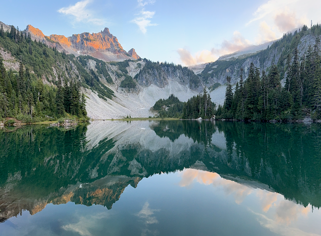
We took the steep trail down to Bench Lake, after stashing our packs, and it did not disappoint. The clouds had totally cleared, the wind was calm, and we got our first good look at Mount Rainier.
The view of Rainier from Bench Lake is spectacular and very accessible. We took a lot of great reflection shots. We were so fortunate to get the weather we did.
After climbing back up to the trail, we had a stroll back to the car. With the fog lifted, it was like a whole new trail.
We were back at the car around 10:30 a.m., where we saddled back up with our day packs and said goodbye to my mom. She would drive our gear back to Longmire, place it in my car, and head home. My uncle and I still had about seven more miles of hiking. It would be mostly downhill.
Reflection Lakes
We were dropped off at the corner before Louise Lake, instead of walking the road, and began hiking west. It was a perfect morning for hiking: clear and cool. We passed the very busy Reflection Lakes parking area and enjoyed the views as we kept walking.
After dodging day hikers, tripods, and group photos, we ducked back into the woods and started descending toward Narada Falls.
The trail was fantastic. It was soft, the footing was good, and protected from the sun.
Narada Falls
There's a lot to see on the south side of the Wonderland. Even if the sightseeing is crowded, it's still beautiful. One of the attractions was Narada Falls. It was a short tenth of a mile off the Wonderland.
We stopped for a break and food at Narada Falls, short of three miles into our longer hike, with more than four to go. After Narada Falls, we continued our descent past some very large trees on a soft trail.
Paradise River to Longmire
We reached Paradise River and stopped to filter water. We now had less than four miles to Longmire, which sounded like a lot of hiking. My legs were starting to notice the descending we had been doing. There would be ways to get water from Paradise River if we really needed to later, but this was the last best spot for clear and cold water until Longmire.
We had a good rhythm going and could feel the end of the hike approaching. I was thinking about how difficult it would be to hike counterclockwise, up from Longmire to Reflection Lakes. I was glad we decided to walk clockwise.
There are a couple of waterfalls between Paradise River and Longmire that we stopped to take a look at.
Getting closer to Longmire, we saw more day hikers. The last part of the Wonderland to navigate was the Nisqually River crossing. A few weeks before our trip, the bridge was knocked out, said the website. However, it's such a popular area, I think they got a replacement in quickly.
On the other side of the river, we began hiking along a wide trail near the road. Soon we were back at the Longmire WIC in view of our cars! It was 2:00 p.m., and it had been about 4.5 hours since we left camp at Snow Lake. All things considered, stopping at the car, etc., it was a quick hike out.
Leaving Longmire
I changed clothes into my "wear-it-homes" using the bathrooms by the parking lot. The area was more active than the day before due to the sunny weather, but the parking lot by the WIC is large and not even close to full.
I had never been to the store or restaurant at Longmire, so I drove down and went inside the gift shop. The gift shop was very similar to the one up at the Sunrise Day Lodge. I found some things for the family and left before having a chance to check out the restaurant. I thought about trying to get coffee, but I had some day old coffee in my car that would suffice.
Leaving the Park
I had a long drive back home, and it was approaching 3:00 p.m. Google Maps was telling me that I couldn't get out of the park at the Stevens Canyon entrance to drive SR-123 down to US-12 to head east. Conversely, I read on the Mount Rainier website that I would be able to get out of the park at Stevens Canyon, contradicting Google Maps. The alternative was taking a longer route back through Longmire and down SR-7 to Morton to get on US-12.
I chose to trust what I read on nps.gov/mora and not believe Google Maps to head out east through the Stevens Canyon entrance. It was the right choice. Practically zero other cars were driving along Stevens Canyon Road with me. It was a pleasant feeling. The sun was out, the views were fantastic, and there was a little coffee to drink. The trip went great.
There was a ton of construction and vehicles at Stevens Canyon Entrance, but I slipped out south on SR-123 and was quickly on US-12.
My drive back took a little longer than normal. Driving along US-12, I noticed a few hikers walking the highway toward Mount Rainier, likely PCT hikers. I realized, in a few miles, US-12 was detoured south, and a large area was closed due to the Wildcat Fire. It was a little inconvenient, but I got to see a part of Washington I had never been to before. It was the longest hike out + drive day of any of my trips, but it was all worth it.