


Introduction
I applied for an overnight Enchantments permit this year. I wasn't surprised when I came up empty-handed in the lottery. I was surprised, however, when my sister asked if I wanted to thru-hike the Enchantments in early October.
I wanted to make a late-season backpacking trip, but this was a tempting alternative. I didn't know people thru-hiked the Enchantments. So, once agreeing to the trip, we had lots to plan:
- We needed a place to stay. It would be Octoberfest in Leavenworth, so lodging could be expensive
- I knew it was a long hike, but I wasn't sure how each section of the hike was laid out
This post is a look at the entire hike. Starting from where we stayed, preparations the night before, and finally, getting through the last mile of the hike.
By the time we finished the adventure, the weather had been nice to us; we saw hundreds of larches, hiked over 18 miles, and the trip was a success. Naturally, therefore, I'm excited to share the details.
Destination:
I use Maps3D to track the hike statistics. It tries to record all the ups and downs that the trail travels across. The measurements aren't perfect and sometimes are inaccurate. However, the majority of the time they offer nice approximations.
The hike was a full day. We spent around 12.5 hours on the trail. After filling out the free day-use permit, we started at 5:00 a.m. from the Stuart and Colchuck Lake Trailhead, traveling from west to east through the Enchantments.
By 9:30 a.m., we had hiked past Colchuck, around the lake, and trudged up to the top of Aasgard Pass (elev. 7,835 ft). From the crest of Aasgard, we had three miles of beautiful alpine lakes, larches, and mountain vistas ahead of us. Additionally, the trail was hectic. At times, you could see lines of 20-30 people. A cold wind kept us (and others) moving through the higher elevations.
By 12:30 p.m., we had seen all the wonders of the Enchantments and started the very steep descent down to Upper Snow Lake. We had five more hours of hiking ahead of us. It was eight miles from Upper Snow Lake, and during the last five hours our bodies started to ache in places we didn't think they would.
We arrived at the second car, parked at the Snow Lakes Trailhead, around 5:30 p.m. Finally, we drove back up to Stuart and Colchuck Lake Trailhead to retrieve our second car. It was Oct. 9, and the sunset was at 6:30 p.m. It was getting dark by the time we got back to the cabin. After dinner, we sat around a fire talking about the day over a couple of beers before sleeping very well that night.
Why Thru-Hike?
As I researched the hike, I had to decide what path to take. Starting from Stuart/Colchuck Lake Trailhead shaves a couple of thousand feet of elevation off the entire trip compared to starting from Snow Lakes trailhead. It was easy to decide that we needed to start from the higher trailhead.
Based on my calculations using Maps3D, if we hiked from Stuart Lake Trailhead to Lake Viviane and then turned around and went back the way we came, we would only be shaving off about 1 mile. Additionally, we would have to hike back up through the Enchantments, adding a climb after the first 8.5 miles after turning around.
Conversely, we could thru-hike, making our total distance a little longer and the total elevation change a little more significant. I decided on the thru-hike because:
- I didn't want to add a climb after we got through the Enchantments.
- I thought the climb out on the east side would be easier to navigate—if we were tired—than stumbling down Aasgard Pass (this may not be the case)
- Thru-hiking is usually preferable to out-and-back for many people.
- I didn't know if I would ever do this again, so I wanted to do the whole thing, and "thru-hiking the Enchantments" sounds better than an "out-and-back to the Enchantments."
With those considerations, we thru-hiked. However, looking back, I would not say that you're making a mistake if you do the out-and-back.
Trailheads
Both trailheads used for the thru-hike are notoriously crowded and busy. Furthermore, the beauty of the Enchantments has caused a mania around visiting the area. Some consider the trail "loved to death."
Consequently, the parking lots fill up quickly, with overflow street parking even becoming a problem and ranger stations having to set rules, direct traffic, and ask for expansions.
An alternative to parking at the trailhead is taking a shuttle from Leavenworth, which I did not look up. Still, many people utilize the shuttle to avoid the parking frenzy.
Stuart and Colchuck Lake Trailhead
The link in the title is the best source of information on the trailhead. This parking area is quite large, in my opinion, and parking is allowed on the right side of the street going up. Roadside parking opens the door for many vehicles having an opportunity to park close to the start of the trail.
The trailhead requires an NW Forest Pass, America the Beautiful Pass, or the Overnight Visitor Parking Pass.
The most notable part of this trailhead is the road in. There are huge potholes and no guardrails. So it wasn't surprising to see cars pulled over with flat tires. High clearance vehicles aren't required, but they probably handle the bumps better than smaller vehicles.
There's a bathroom (pit toilet) and an information board with an area to fill out a day-use permit. We started at this trailhead because it's at a higher elevation, thus making the overall incline in the hike less than starting at the Snow Lakes Trailhead.
Snow Lakes Trailhead
I remember this trailhead undergoing construction in 2020. I believe it has fewer parking spots than the Stuart Lake Trailhead. Similarly, cars can park in various spaces along Icicle Creek Rd.
It has a bathroom, picnic benches, and a lovely bridge that goes over Icicle Creek. Unlike the shaded Stuart Lake trailhead, this parking lot is exposed to the sun.
Again, the trailhead requires an NW Forest Pass, America the Beautiful Pass, or the Overnight Visitor Parking Pass.
Before the Trail
For the best planning information, check out the Okanogan-Wenatchee National Forest site on Enchantments Area Permits.
They have route updates, road closure information, lists of restrictions/rules, advice on dealing with goats, choosing gear, and other helpful links on planning the trip.
Lodging
Everyone in the group was a few hours' drive from the trailheads, so we needed a place to stay that would allow us to start early. We were looking for two nights, Friday (the night before) and Saturday night (the night of).
Also, it needed to be reasonably priced. Leavenworth can be pricey in general, and we made the search harder when we decided to go during Oktoberfest.
Against the odds, we found Camper Cabin #5 and Cabin #3 at the Icicle River R.V. Resort on Airbnb.
The cabins don't have running water, insulation, or heating/cooling. They have a light and one power outlet. Additionally, there are three beds: two twins and a double. They have essentially converted sheds to act as cabins, but they were ideal.
The R.V. resort was very busy, but we snagged cabins 3 and 5 for about $80/night, including additional charges.
There are:
- Bathrooms and showers on-site (our bathroom was very close to our cabin)
- Parking (and overflow parking)
- A fire pit, which we could use since the burn ban was lifted by October 9.
The best thing about these cabins is they are 3 minutes from the Snow Lakes Trailhead and ~27 minutes from the Stuart Lake Trailhead—making it easy to get an early start.
We had to bring our sleeping bags, water, and cooking gear, but they were perfect for what we were in town for. It got cold, so we brought our backpacking sleeping bags. The R.V. park is only a few minutes from town.
Weather
The Okanogan-Wenatchee Enchantment Area Wilderness Permit site posts a weather link from NOAA that I'll include below. This link is for the Enchantments, not Leavenworth. Weather for Leavenworth can be searched more easily using popular weather apps or sites.
The Night Before
As previously mentioned, we were only three minutes from the Snow Lakes Trailhead. We planned to leave a car there to drive back to the Stuart Lakes Trailhead after completing the hike on Saturday. Around 8:30 p.m. on Friday (the night before the hike), we went to the Snow Lakes Trailhead to park the car.
It was a beautiful night: cold and clear. My brother took a picture using his phone that did a pretty good job of capturing the night sky.
Photo credit Jordan Retz
We found ample parking opportunities at 8:30 p.m. We parked the car in a great spot, which meant that we wouldn't have to try to park it in the morning before we started.
Surprisingly, the trailhead was busy! Other cars were showing up, and a few groups were gearing up to start their hike that night! Furthermore, we saw headlamps higher up on the ridge. Some groups were making their ascent! Our decision to drop a car off at Snow Lakes Trailhead the night before turned out to be a good move.
Unfortunately, I forgot to grab a permit, so I wouldn't have to fill it out at the trailhead the following day.
We got to bed a little after 9:00 p.m. on Friday, anticipating an early wake-up on Saturday.
Stuart Lake Trailhead to Colchuck Lake
Getting Started
We woke up at 3:30 a.m. to a chilly morning. After eating some breakfast and double-checking our gear, we left the cabins around 4:15 a.m. It was still very dark, so we had our headlamps ready.
We passed the Snow Lakes Trailhead shortly after leaving the R.V. resort, and it reinforced our decision to leave a car there the night before. It looked like a mess. Cars coming in, stopped partially on the road, lots of headlights and some emergency flashers on.
We could cruise by and didn't see that many cars as we climbed up to Stuart Lake Trailhead.
Arriving at the Stuart Lake trailhead at 4:45 a.m., cars had already started parking on the street. Also, multiple groups of people were just out of their vehicles getting ready to hike. We walked up to the start of the trail and passed the pit toilet, which had a line ten people deep (if not more). I needed to use the restroom but resolved to wait until Colchuck Lake.
Equally troubling was the line to fill out permits. Thankfully, I had anticipated this problem and brought my pen! I jumped to the front, grabbed a permit, and walked away to fill it out. After attaching it to my pack, we started hiking at 5:00 a.m. Avoiding the restroom, and having a pen, helped us get out on the trail ahead of many other groups trying to start at that time.
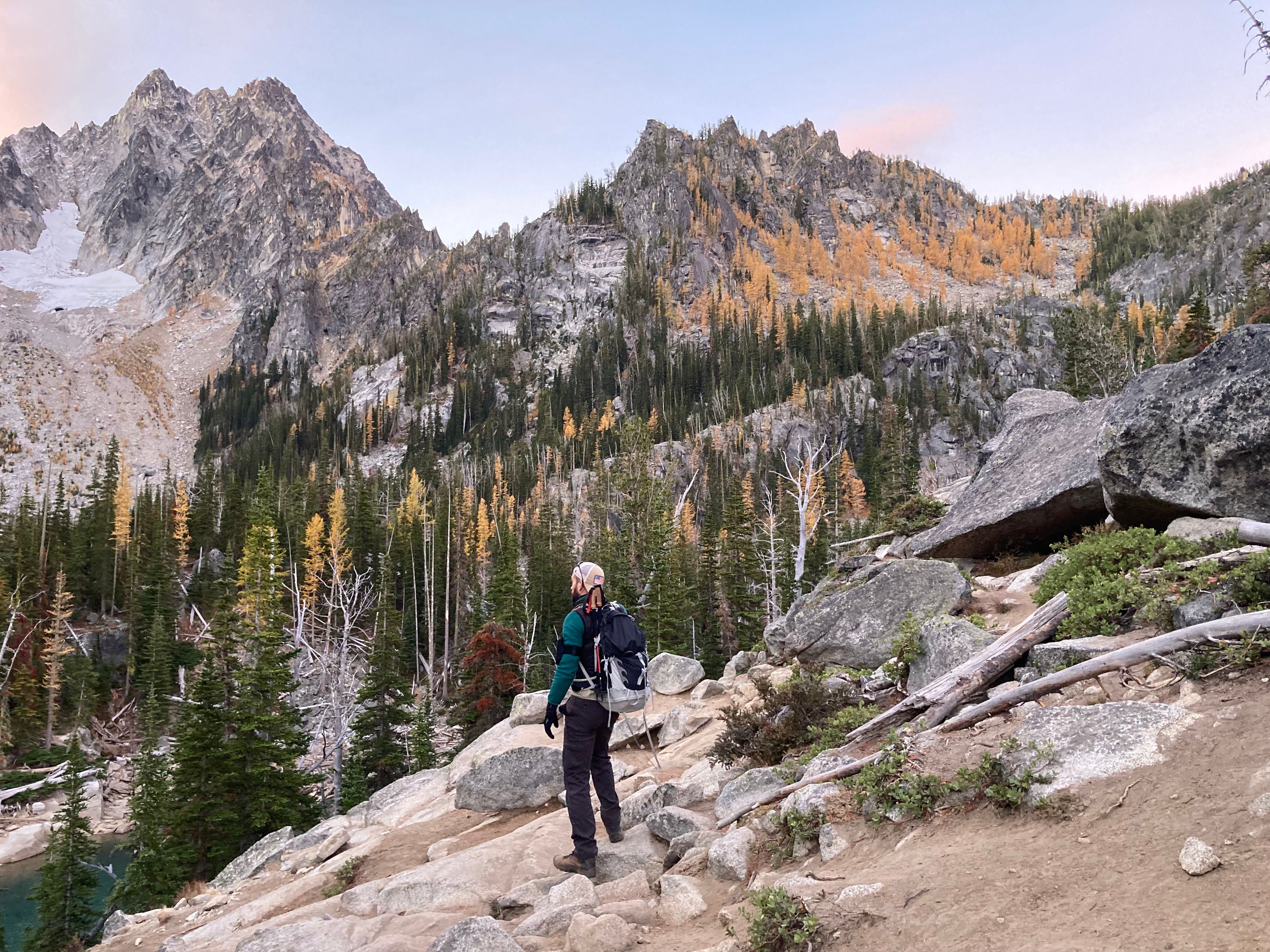
Hiking in the Dark
The sunrise wouldn't be up until ~7:30 a.m., which meant we would hike almost to Colchuck Lake in the dark. I had walked to Colchuck before but still was checking the map on my phone as we hiked. The trail to Colchuck was pretty easy to follow, and having headlamps helped.
Hiking in the dark is enjoyable. The air was cool, and I felt like we were making good progress. The sky started to brighten as we made the last ascent up to Colchuck.
Photo credit: Jordan Retz
Colchuck Lake
It was still cold when we stopped at the first pit toilet at Colchuck. At this point, the ridges around Colchuck started to get some light. That uncovered a range of colors that made for beautiful scenery around the lake. I wasn't conscious of it at the time, but the larches around Colchuck were peaking.
Instead, we were in awe at the color of the water, the yellow larches on the slopes, and the impressive peaks surrounding Colchuck.
The trail is a little messy around Colchuck. Additionally, many splitter trails and campgrounds make it easy to wander off the main route around the lake.
Once we made it to the south side of the lake, we began boulder hopping beneath the shoot that holds the Colchuck Glacier.
Aasgard Pass in the distance before we started boulder hopping
The views up the pass between Dragontail Peak and Colchuck Peak were stunning. The colors of the rocks, the larches, and the Colchuck Glacier kept our phones out as we crossed the boulders.
The boulders, and various areas around the lake before the start of the Aasgard Pass climb, make for excellent break spots.
We were about ten minutes behind schedule when we stopped for a break around 7:30 a.m. We were close to the base of the climb up to Aasgard Pass.
My brother looked up toward the start of the climb and counted 20-30 people in a line on the first portion of the trail. It started to feel like a pilgrimage at that point.
Aasgard Pass
We started up toward Aasgard Pass at 8:00 a.m. In my planning, I had us conquering this ascent in two hours—starting at 7:40 a.m. and ending at 9:40 a.m.
Getting started on Aasgard Pass
It's every bit as steep as people say. Making matters more difficult was the multiple paths that have been carved out by people going up. However, some cairns help guide your movement.
REMEMBER TO STAY LEFT, ESPECIALLY AT THE PINES IN THE MIDDLE, TO AVOID THE WATERFALLS.
I tried to use my best route-finding judgment, looking for switchbacks and trying to avoid going straight up. We frequently stopped to get a quick breath but never sat for an extended break.
We were fortunate that no fresh snow was on the trail, and ice was at a minimum toward the top.
Once we passed the patch of trees in the middle of the climb, it became more difficult. We were now approaching, if not above 7,000 ft. I was starting to notice the elevation in my energy level, head, and breathing.
That was all the more reason to pause and appreciate the spectacular peaks, rock formations, and views that are available on the climb.
A Note on Route Finding and Safety
It's easy to get in the habit of following the person or group ahead of you. However, people often take aggressive or difficult routes on the ascent that might not be the best way up. So now and again, I suggest pausing, identifying the next cairn, and surveying the options.
If you get into a steep chute that looks pretty vertical, it may not be the best path. Furthermore, falling rocks become more of a problem when people are on a steep slope walking on untested rocks above you.
Off Trail
There are two trails at the top of this climb. Once you're past the pines, you'll come across the large rock face of a waterfall. There is a path to the left and a few paths to the right. We chose a path to the right that was below the actual trail.
We ended up off the trail and had to make an energy-wasting ascent to reunite with the trail. It was expensive, and we paid for it.
Little patches of snow started to appear as we got within a few hundred feet of the pass, and there was some water on the trail but nothing that warranted extra traction gear.
The first person in our party to reach the top did so in about 1 hour and 15 minutes. The rest of the group made it up at 9:30 a.m. putting our total Aasgard pass climbing time at 1 hour and 30 minutes.
This put us ahead of schedule by ten minutes! We had made up all the time we lost, starting a little later and rounding Colchuck.
Upper Enchantments
I was so excited to see the Enchantments that I wasn't tired at the top of Aasgard. I was energized to get over the next hill and see what was ahead.
Top of Aasgard
The Upper Enchantments was a cold, alpine setting. There were a few snow patches and glaciers that hung out below the charred ridge at the top. The lakes had limited vegetation. Most of it is very close to the ground.
Not long after we started enjoying the Upper Enchantments, we stopped to gear up because it was freezing. The wind was chilled, making the air feel much colder. We came across a few groups sitting directly behind rocks, facing east, avoiding the wind coming from the west.
The area's larches were all past peak. The trees were darker and primarily colorless, giving the environment a desolate look. It was evident that winter would be here very soon.
It wasn't long before we were walking alongside the Brisingamen Lakelets. Then, finally, some blue sky helped lift the gray veil of fall and reinforced the beauty of this trail section.
The Upper Enchantments are pretty flat, making the hike more like a stroll. Some cairns guide hikers over granite sections and poles (10-12 ft.?) that act as waypoints.
There was a silver lining to missing the peak larches that we didn't predict. The golden needles fall to the ground and create a bright yellow dusting where trees are bunched together. Knowing that I like to write about my hikes, my brother asked, "Going to put that in the post?". Absolutely.
I was getting hungry. We didn't stop after Aasgard because the wind was strong. However, the wind was still strong as we descended to Inspiration Lake, the first of the middle Enchantments.
Middle Enchantments
Shortly after Inspiration Lake came into view, I spotted a small sandy area that looked out the lake and had vistas south toward The High Priest and The Temple. It's a spot where the trail gets narrow and is just before the steep drop down the Inspiration Lake. You can't miss it.
I decided that we should stop there because I was quite hungry. It was almost a perfect spot. But, the wind was still ripping through that area, and the rock wall to the west did little to break its path.
Regardless, we sat, ate food, and became cold.
A Note About Gear
People in shorts, running shoes, sweatshirts, and drawstring bags (maybe carrying a few water bottles and food) made their way past us as we sat. It wasn't the first time we noticed people with surprisingly scanty gear. The weather report forecasted high temperatures around 31 degrees Fahrenheit for the Enchantments (with the wind, it felt colder), and a few snowflakes fell on us in the Upper Enchantments.
It made me think, are we over-geared for this hike? Later, I rationalized the difference in gear choices by comparing risk. People who run the Enchantments, thus wanting to carry limited gear, are deciding to increase the risk of getting caught out in the elements due to injury, poor navigation, etc. Similarly, hikers wearing shorts have one option: keep going. It would have been too cold to stop or rest.
On the other hand, I may have been a person not to have all the recommended gear in previous years. Regardless, it's hard to look at people's gear choices and not think, this is why search and rescue teams are up here every week. I think the ethic here is to make an effort not to become someone else's problem on the trail.
Inspiration and Perfection Lake
The trail gets tight and steep as it falls into the Inspiration Lake basin. Dark and light shades of rock make for spectacular contrast as the backdrop of the lake. My map shows the trail splitting as it crosses Snow Creek flowing out of Inspiration. Choosing to go right drops you down into the Perfection Lake basin. Going left takes you along Inspiration Lakes shore.
Both trails meet up again on the north end of Perfection Lake. However, it's worth noting the divergence. We stayed to the left and traveled along the shores of Inspiration.
Larches were everywhere in the middle of Enchantments—some, very "larchy", others, past their prime. As we rounded a corner, turning away from Inspiration Lake, the wonders of this hike were before our eyes. Perfection Lake is aptly named.
Large granite boulders lead the way down to groves of scattered larches on the west side and a small forest of larches on the north and east ends of the lake. Also, on the north end, a quaint footbridge takes you across a perfectly clear stream flowing into the lake.
Photo Credit to Jordan Retz
We were walking amongst the magic on the east side of the lake through thick larches, on a golden path, with eyes scanning the south, west, and northwest shores.
Looking to the northwest from the trail on the eastside, you see the rocks and ridgeline with characteristics iconic to the Stuart Range.
The golden trail on the eastside of Perfection Lake
The south end of Perfection Lake appears to drop off a cliff, with a window looking out into the rest of the world. The trail turns away from the lake after it brushes up along the shore, and you again cross snow creek.
Crossing the creek, and slowly losing elevation on the approach to Leprechaun Lake meant we were entering the third and final stage of the Enchantments.
Lower Enchantments
The section of the trail from Perfection Lake to Lake Viviane (including Leprechaun Lake) is a special part of the Enchantments.
The white-washed granite is everywhere—cut in some places and smooth in others. Larches grow where the soil is sufficient.
An older man and his significant other were stopped, photographing a brilliantly colored larch leaning over granite. Behind the larch were the High Priest and the Temple, which watch over Lake Viviane below. There are innumerable photographic scenes around this section.
We stopped at a pit toilet (there are many) above Lake Viviane, just beyond where Snow Creek ferries water from Leprechaun Lake into Lake Viviane.
We didn't know it at the time, but we were about to start a steep and rocky part of the trail that would leave our legs aching.
Lower Enchantments to Upper Snow Lake
The trail hugs a granite knob as it moves past Lake Viviane. Then, the edge of the trail on the Lake Viviane side falls away, revealing some exposure. After carefully navigating the rocks and tree roots through this section, you come to a rocky shelf with a great view of the Snow Lakes basin below.
It's a popular place for a group photo!
This section of the trail has rebar welded/pounded into the rock. It's the part of the trail that could be very dangerous given the weather conditions. Furthermore, there were multiple areas descending from the Enchantments on the east side where the trail was simply walking on an angled granite face. Often, a steep angle.
Incredible views were still accessible standing on the precipitous trail as we made our way down to the shore of Lake Viviane. Similar to Lake Colchuck, the larches were peaking at this elevation and throughout the slopes surrounding Upper Snow Lake.
On the shore of Lake Viviane, we said goodbye to the Enchantments and eyed our next destination: Upper Snow Lake.
We started descending from Lake Viviane at ~12:30 p.m. It was remarkable, surprising, and painful how steep, rugged, and rocky the descent out of the Enchantments is on the east side. We said multiple times that ascending Aasgard is no doubt preferable to coming up this side.
At best, it makes your knees ache. At worse, you're seriously injured if you make a wrong step. I think I mapped the distance at 1.3 miles from Viviane to the shores of Upper Snow Lake and set aside one hour for the descent. However, it took longer and felt longer than I had predicted.
Morale was lower and dropping. There were no more Enchantments, and we were barely more than halfway through the hike.
As my sister remarked, it felt like the "end of the hike" was Snow Lake. And we had to finish this descent for it to be over soon. However, that mental juke was far from the truth, and it depressed us to think that getting to Snow Lake only meant another eight miles.
The trail oscillated between dirt, rocks, and a mixture of both. Our extra layers that served us so well at 6-7k ft. were a burden now. I can't remember what time it was that we finally made it to Upper Snow Lake. Navigating the steep drops on this section of the trail, and knowing the amount of work we had ahead of us, was easily the low light of the hike.
Upper Snow Lake to Snow Lakes Trailhead
There was a group of runners sitting at the bridge that had passed us on the way down. Other groups were breaking and filtering water. I, too, needed water, but the crowd made me want to continue and find a quieter setting. Unfortunately, this turned out to be a bad idea because the lake level of Upper Snow Lake was so low that the creek beneath the bridge was, in actuality, the best spot to filter water.
The shoreline was way down, so far down, it wasn't even worth it to drag our gear down there to refill. Regardless, we pulled off the trail not far after we hit Snow Lake. We ate and removed some layers now that the temperature was higher (lower elevation) and the breeze was gone.
We had about four more hours of hiking to go: all downhill, but wow—the trail around Snow Lake was a blessing! It was generally flat with soft dirt. I felt like I had new legs.
There wasn't much to note for this section of the trail. The lake level was low, so it felt like we were hiking alongside a reservoir. We crossed the dam/divider between Upper and Lower Snow Lake, still looking for good water to filter. Finally, we found some on the shores of Lower Snow Lake. Unfortunately, we had to go off-trail to get beyond the logs and stagnant water by the divide. Then, I wandered through some light trees to a muddy spot on the shoreline with better water.
After filtering, and a short break, the mood improved. We still were a long way from the car, but the break helped. We were talking more, and we had provisions.
Around 3:00 p.m., we had hiked past Nada Lake (funny if you say it because it sounds like "Not a Lake"). We were still enjoying the relatively flat trails that work around the shoreline.
Nada Lake was the last of the lakes to see that day. Not long beyond Nada Lake, we could see out of the valley toward Leavenworth and, soon, we crossed over Snow Creek.
The valley we were now in, between Wedge Mountain and essentially Edward Peak, is steep. There are a series of switchbacks followed by slower declines.
We took short breaks and tried to hobble along the trail as best we could. Undoubtedly, it was a scenic part of the hike. Fall forces much of the foliage to turn colors and, as a consequence of the fires and steep slopes, many deciduous plants light up the trail.
Additionally, there is a pleasant cedar grove approximately 2-2.5 miles from the end of the trail that helps to distract you from thinking about the minor pains in your legs.
The parking lot is a tease as you begin the final section of switchbacks which are cut dramatically right above the Snow Lakes Trailhead starting just after Icicle Creek.
Photo Credit Jordan Retz
It was fitting to get some blue sky and a few rays of light as we finished out the long day. We made it to the parking lot right about 5:30 p.m.
We had spent 12 hours and 49 minutes on the trail. After a couple of high-fives and fist bumps, we got back in the car, ate some victory chocolate, and started our drive back up to Stuart Lake Trailhead.
Conclusion
We tossed around the idea of going into town for food and beer, seeing that it was still Oktoberfest, but we opted to grill up some food at the cabin and have a fire.
We debriefed around the fire over food and a few drinks, but the night didn't last long. We were put to sleep by a healthy combination of a long hike, food, beer, and flames. There was no trouble sleeping that night (at least for me!).
Photo Credit Jordan Retz
It's easy to think, what would I have done differently? Or, if I were to do it again, would I do it the same way? It was consensus that we would not start from the Snow Lakes Trailhead, but it wasn't unanimous that we would want to turn back and hike down Aasgard Pass.
Time will tell whether we get a chance to return and try an out-and-back from Stuart Lake Trailhead. Until then, I'm pleased with the success of this hike and am grateful for the opportunity to complete it with friends and family.