


Introduction to Hiking Series
With my recent move back to the desert (La Quinta, CA) I wanted to chronicle a series of hikes where I provide the information that I sought out before the hike, or discovered later, because this information was what I needed to know.
I’m 25, in decent shape, usually hike alone (not always by preference), and like to plan a decent amount. If that’s relatable, I suggest continuing. The hikes I’m choosing are for slightly more experienced hikers with sometimes a little travel time, sometimes a lot of travel time.
When I talk about weather, finding trails, or trail stats these are the apps where I get that information from:
- I find hikes mostly using the AllTrails app.
- I use Maps 3D when I’m actually on the hike (love it)
- I use NOAA Radar or Weather Bug for weather
If you are interested in other hikes that can be reached from the Coachella Valley, below are some small posts, that may or may not be useful from last winter (some might just be a picture actually)
- Bear Creek Oasis
- Bogert Trail to Murray Hill
- West Fork Trail – Indian Canyons
- Palm Springs Aerial Tramway
- Eisenhower Mountain
- Art Smith Trail
- Joshua Tree
- Bump & Grind
- Painted Canyon Trail
I need to add a disclaimer, that although I intend for my posts to be used as trip reports, or helpful guides, you are still hiking at your own risk. You should always carry the survival essentials, let others know your hiking/route plans, and favor caution.
Quick Stats for Hike 10
- Total Time: This excursion took ≈24 hours
- Date(s): April 19-20
- Driving Distance: ≈50 miles (from La Quinta)
- Hike: 14.17 miles, desc./asc. ≈5,602 ft., 9 hours 12 minutes, trailhead elevation 6,572 ft.
- Expenses: Food, Gas, One-Day Adventure Pass ($5), Campsite ($32.99)
Destination:
On a few of the previous hikes in this series I would reach the peak, in triumph, only to see a higher one. I knew that my time in the desert wouldn't be complete until I ascended the grandfather of the valley. That being said, from the beginning, I knew that this would be the final hike.
Two years ago I was driving through the area on my six week road trip. My eyes were fixed on the enormous San Jacinto Peak planted along the I-10 corridor. Unlike looking at Mt. Rainier in Washington (above 14,000 ft), San Jacinto Peak has always been within my abilities.
More recently, I would see the peak almost everyday after I turned off Washington and drove west—on Highway-111, to work in the mornings. I would glance up to examine the snow as I left the gym in the afternoons and wonder how much was truly up there. I wanted to wait as long as I could to let as much snow melt as possible.
I was moving back to Washington—as the golf season came to a close—on April 24. I didn't want to hike it alone, so I picked a day when my brother could join me. We camped at Idyllwild Campground the night before so we could get to the trailhead early in the morning, and complete the hike in one day.
Much of the trailhead information, as well as some other details, remained the same from the previous hike, so I borrowed some of the sections. However, it varied in many other ways—all of which seemed to be positive. The trailhead information below is the same from the previous hike (and has permit information), but after that I will get into the preparation and hiking portions.
The Trailhead
The gold star marks the approximate location of the trailhead. It’s ‘just above’ Idyllwild, CA.
The trailhead is called Humber Park, but is also known as Devil's Slide Trailhead. It is located northeast of Idyllwild, and is only ten minutes from downtown.
It takes 1 hour and 15 minutes to reach from La Quinta, and I was able to access it via Highway-74, then Highway-243. From Idyllwild Campground, it takes about ten minutes as well. Due to the weather this winter, there was damage on Highway-243 and Highway 74. Highway-243 it is closed north of Idyllwild and Highway-74 is closed between Hemet & Mountain Center as of 4/19/2019 (which doesn't affect hikers coming from the valley).
The roads up to Idyllwild have a lot of curves, and can be quite narrow. The same is true all the way to the trailhead. Due to the fire, further down the slopes, there can be construction crews using one of the lanes.
Before hikers get to the trailhead, they will need to get a permit at the ranger station and a parking pass (unless they already have one).
Permits on Devil's Slide trail are limited on weekends between Memorial Day and Labor Day. On these days, the permits are ONLY given out inside. They cannot be filled out ahead of time.
The ranger station is on the way to the trailhead, and the parking pass can be bought at the Shell or Chevron stations for $5. The address for the ranger station is 54270 Pine Crest Ave, Idyllwild, CA 92549. There is a list posted outside the ranger station that has vendors names on it for parking passes. What is nice about the pass is that it can be bought in advance (even for daily) and then a person can scratch the day and month that they will be using it for.
I arrived at the ranger station when it was closed, but that was totally fine because everything one needs for the permit is outside at a nice booth (as well as other useful information).
Booth outside of Idyllwild Ranger Station.
The permit takes a minute, or two, to fill out. One copy is kept with hiker, the other goes in a slot. The booth has weather conditions, trail updates, where to buy parking passes, and much more information.
I read a description on AllTrails that stated, "Get a wilderness permit. You are bound to come across a ranger on this trail (especially on the weekends). The Devil's Slide trail is overused and on a quota system, they will ask for it."
I had to make the tiny drive down to the Shell station to pick up a parking pass, but then found Idyllwild Campground, which is just up the street from the ranger station.
Preparation
I started planning for this hike months before. I created a Google Docs with some useful information that I could assemble and share with my brother. The original route that I chose was from Marion Mountain campground, but the campground doesn't open until May.
In light of the snow, and the campground availability, I decided to change course and start from Humber Park. The two links below were the sites I first looked at (both were on the SoCal Hiker site).
https://socalhiker.net/hiking-mt-san-jacinto-via-marion-mountain-trail/
https://socalhiker.net/hiking-mt-san-jacinto-via-humber-park-idyllwild/
An important aspect in the planning process was booking the campsite. Starting the hike early was key because I estimated that it would take about nine hours, and with the amount of snow still present, we wanted to make sure we were summiting mid-to-late morning. This would ensure the snow was still fairly dense, as opposed to slushy, on the ascent. The wind was forecasted to pick up in the afternoon, as well as possible cloud coverage, so all signs pointed to an early start.
I was periodically checking a website, run by Jon King, that has San Jacinto Mountain trail reports. It was very helpful, and because of the reports, I only brought micro-spikes + hiking poles to handle the trail conditions (no crampons or ice axe).
The campground was at elevation, so warm camping gear was required as well as extra food. The campground is right next to downtown, so last minute supplies are easy to grab. It took me only a few minutes to walk to the market and get firewood.
I bought the parking permits the night before, since they are scratch-off, and filled out the hiking permit so we could just drop it in the slot on our way to the trailhead. Everything was set except for one detail that I did not anticipate. The campsites were very close together.
I chose a tent only site and it had a fire pit, small parking spot, and picnic table. It's proximity to other campsites isn't that big of a deal, unless, one plans to wake up at 4:00 a.m. and cook breakfast. Out of respect for others sleep, we modified our plan to gear up, and eat, at the trailhead. The trailhead has a picnic table, which I used, and it ended up being a great alternative.
The night time low was estimated to be around 45 degrees. My brother and I were hanging out around our small fire, knowing we should be headed to bed soon, but the fire was warm and we could see big constellations starting to appear in the sky overhead. Falling asleep wasn't difficult, but I can't say I slept great. The campground was a little noisy around 9:30 p.m. and the moon (practically full) was fairly bright. Both of these factors contributed to less than ideal rest. Regardless, there was still a hike to be had in the morning.
The Hike
We carried—and wore—base layers, extra socks, gloves, poles, micro-spikes, headlamps, waterproof hiking boots, medical supplies, face-shields, sunglasses, portable charger, extra shoelaces, chapstick, and extra food. I brought a water filter incase we were running low on the descent, however, 56 oz. was enough for me during the hike.
Despite a slight delay (I missed a turn on the way to the trailhead), we arrived early—it was still dark—but the full moon provided some nice light. It took approximately 25 minutes to get a bite, gear up, and double check our supplies. It was about 5:00 a.m. and we were the only two people stirring around at the trailhead.
The wind was much less of a factor—compared to the last time I was here, and I knew that we would warm up quickly as soon as we started hiking. I took one last look at my watch, it was 5:10 a.m., switched on my headlamp, and we began.
I mentioned in my last post that Devil's Slide is a great hiking trail. It climbs steadily up towards Saddle Junction. There are nice views of Suicide Rock, Lily Rock, and back at the valley to the west. We had a lively discussion going and that caused the miles to go by quick and easy. After about a mile, I stopped to shed a layer, and a half mile after that I turned my headlamp off. The short stops provided a nice chance to appreciate our morning view.
Still fairly dark, but the changing colors and full main made for a nice setting. Suicide Rock pictured in the center.
We made good timing up to Saddle Junction, and there was only two small patches of dirty snow that we encountered on the way up. The hike up to Saddle Junction is approximately 2.4 miles, and gains around 1,800 ft. From Saddle Junction, we would do a small stretch on the PCT before shooting off on the Wellman Divide trail.
Obviously, we followed the sign to San Jacinto Pk.
The wind picked up as we ascended the switchbacks on the PCT. At 6:31 a.m., the sun appeared through the trees and gave some light to the beautiful landscape that we were hiking in.
A snowy Tahquitz Peak to the south as we ascended on the PCT.
We hiked past some awakening PCT hikers, who had a windy night, that camped just before the snowy trail conditions began. The trail was icy in the trees and we strapped our micro-spikes on at 8,850 ft. (3.5 miles into the hike). Half a mile later we made it to the second trail junction.
Trail junction sign on the PCT.
We would be leaving the PCT trail (as it is outlined on Maps 3D) and heading towards Wellman's Junction.
This was a glorious time in the hike. The morning sunlight had an effect on the trees, the snow, and the sky that reminded us why we were up here. The temperature, as well, was cool and ideal for hiking.
The next section of the hike was on the slopes below Marion Mountain. Halfway through this part we took off our micro spikes due to the lack of snow on the south facing slopes.
The trail had a little snow on it, but it became scarce on the south facing slope.
Also noteworthy, on the south facing slope we crossed a small stream that feeds into Willow Creek. There was enough water here, given the conditions, to filter if need be. The stream was approximately 4.9 miles in.
Our next stop was Wellman's Junction, which is a popular spot for a rest, at 9,700 ft. Below is the trail junction sign for that area.
2.3 miles to the peak
We had a fairly uneventful traverse below Jean Peak. The micro-spikes came back on at Wellman's Junction and we noticed that there were a few different 'trails' (people's footprints) on the slope. In a stretch of 50 ft there seemed to be three different paths that people had taken.
As we were examining the different footprint paths, a hiker appeared up ahead. He said to us that there were many splitter trails, and they had taken the wrong one the night before. I'm not sure where they camped, but it had obviously frustrated their group. We would soon have our own questions as we got higher up the slopes of Round Valley.
There is a small area at the base of the final ascent that was a bit troublesome. The red lines in the image above show our ascent and descent, and the black circle shows the area where many people seemed to be making up their own routes.
Footprints went off in many directions here, and it's not clear where the main traverse is. After walking around, and gazing up the slope trying to see where the main traverse was, we finally picked some footprints that we trusted. It was a bit of tough hiking. We were at elevation, the snow was getting softer, but the traverse we chose eventually lead us up to a more traveled path. Below is a picture I took on the descent. It shows a part of the black circled area I mentioned in a previous screenshot. Looking at the picture closely, one can see many footprints—and paths—below.
Picture was taken about 600 ft below the summit.
Looking at the screenshot again, one can see that the trail on Maps 3D (normally fairly accurate) is not reflected accurately by the footprints we followed through the snow. Something I did make note of, to gauge how we were doing through this section, was our elevation relative to the dotted trail line on Maps 3D. This gave reference to where on the slope we should be traversing.
Looking back on the main path we eventually found.
Pausing for a moment to examine our path in relation to other footprints.
There were some very direct footprints on the slope that seemed to take a very steep route. Later, we recognized that these were people coming down off the mountain, and not climbing on the way up.
About 300 ft. below the summit there was a stretch of trail that we were careful on. The slope is fairly steep, and falling could cause a bit of a slide. Taking careful footprints we made it across. The snow wasn't very icy, so the risk was diminished, but we made a point to take extra caution.
I wasn't looking at the map, so as we approached the highpoint we could see what we thought was the peak. In reality, this was just a small ridge-line, and we still had about 200 ft. to ascend. It was a little disappointing, but no where near devastating. Hiking above 10,000 ft., our muscles felt more fatigue than normal, and we had to make frequent stops to catch our breaths. One of those stops was at the shelter, which I had forgotten about.
Pausing for a moment to examine our path in relation to other footprints.
Ladders, and other equipment.
There was emergency supplies, four bunks, and a lot of names/stickers.
It was a short trudge to the summit at this point. One hiker passed us going down before the shelter and, remarkably, we were the only ones at the peak when we arrived at 10:00 a.m. It had taken us 4 hours and 49 minutes to hike 7.15 miles, gaining 4,827 ft.
The wind was right around 20-25 mph at the top, but we ducked behind the rocks, facing southwest and looked down into the hazy Coachella Valley. At times, the wind slowed down and it was surprisingly quiet. There were a lot of footprints. We were wary of the snowy slope on the north side of the peak and didn't get too close.
I had read that there was still about 3′ of snow at the summit. However, someone helped dig out the sign.
Jordan with San Gorgonio over his right shoulder, and Clearwater Reserve to his left.
Little bit of shelter behind the rocks. Looking west.
I pointed out a few of the places to Jordan that I had hiked previously, and we tried to take in as much of the view as we could.
I was unsure how long we would stay at the peak, because of the conditions, but it was very tolerable. We ate, took pictures, and walked around for about 40 minutes at the top.
The first part of the descent was nice. Our boots sunk into the slushy snow and cushioned our steps. We cut across a snowy section after we ended up following the wrong footprints on the descent (which is why there are so many confusing footprints in the first place).
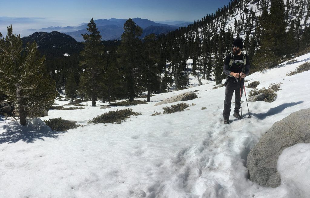
Jordan, adjusting micro spikes.
We saw a few hikers towards the summit—on their way back down—but mostly had the trail to ourselves. It wasn't until we got closer to Wellman's Junction that more people appeared.
At Wellman's Junction, on the descent, there were quite a few people making a quick stop. A girl asked if there was anyone at the peak when we were there. We told her no, but we had passed around ten in the last five minutes. She mentioned that the 'tram people' were on their way up now (herself being one of them).
Due to our early start, we were ahead of the first tram trip. It wasn't exactly planned, so we definitely lucked out. Descending below Wellman's junction we saw an increasing amount of people. It was a sunny Saturday and we ended up passing many day hikers, dogs, through hikers, and one cross-country skier.
Besides the occasional picturesque scene, it was a steady descent.
Jordan, adjusting micro spikes.
Nice view from the trail looking down on Tahquitz Peak.
It was nice to see the parking lot again and take off my boots, giving my feet and legs a rest. The entire hike took 9 hours and 12 minutes, covering a distance of 14.17 miles, and ascending/descending a total of 5,602 ft.
The whole excursion had worked out almost exactly as planned, and the weather cooperated. We met my brother's wife, and popped down into the Idyllwild Brewpub for a few beers.
After a couple of beers it was easy to reflect on the whole hiking series, starting back in November, and culminating in this grand summit. I was thankful that I had been given the chance to walk along such gorgeous trails.
The Coachella Valley has easy access to such a variety of different landscapes, and I'll certainly miss the short drives to some of these gems.
A Few Things to Note
- There was flowing water on the hike, but that will not always be the case.
- There are bears that sometimes wander around this area.
- Weather and trail conditions can change quickly. Check out the ranger station site, or www.sanjacjon.com for trail updates.
- There is a bathroom at the trailhead.
- Hiking permits are limited on the weekends for this trail between Memorial Day and Labor Day. Permits must be picked up inside the station.
- Parking pass required.
- Conditions can change fairly quickly at the peak.
Thanks for visiting the site, and I hope this was entertaining, or helpful, in some way. Please, share any thoughts that you may have!