


Introduction
With my recent move back to the desert (La Quinta, CA) I wanted to chronicle a series of hikes where I provide the information that I sought out before the hike, or discovered later, because this information was what I needed to know.
I’m 25, in decent shape, usually hike alone (not always by preference), and like to plan a decent amount. If that’s relatable, I suggest continuing. The hikes I’m choosing are for slightly more experienced hikers with sometimes a little travel time, sometimes a lot of travel time.
When I talk about weather, finding trails, or trail stats these are the apps where I get that information from:
- I find hikes mostly using the AllTrails app.
- I use Maps 3D when I’m actually on the hike (love it)
- I use NOAA Radar for weather
If you are interested in other hikes that can be reached from the Coachella Valley, below are some small posts, that may or may not be useful from last winter (some might just be a picture actually).
- Bear Creek Oasis
- Bogert Trail to Murray Hill
- West Fork Trail – Indian Canyons
- Palm Springs Aerial Tramway
- Eisenhower Mountain
- Art Smith Trail
- Joshua TreeBear Creek Oasis
- Bogert Trail to Murray Hill
- West Fork Trail – Indian Canyons
- Palm Springs Aerial Tramway
- Eisenhower Mountain
- Art Smith Trail
- Joshua Tree
- Bear Creek Oasis
- Bogert Trail to Murray Hill
- West Fork Trail – Indian Canyons
- Palm Springs Aerial Tramway
- Eisenhower Mountain
- Art Smith Trail
- Joshua Tree
- Bump & Grind
- Painted Canyon Trail
I need to add a disclaimer, that although I intend for my posts to be used as trip reports, or helpful guides, you are still hiking at your own risk. You should always carry the survival essentials, let others know your hiking/route plans, and favor caution.
Quick Stats for Hike 5
- Total Time: This excursion took ≈6 hours
- Date: January 23
- Driving Distance: ≈33 miles
- Hike: 10.88 miles, desc./asc. ≈2,821 ft., 4 hours 32 minutes, trailhead elevation 1,222 ft
- Expenses: Food, Gas
a ,This hike didn't lead to a waterfall or mountain top. It was, actually, inspired by a stop at rest area a few months ago, and my general curiosity. When I was moving back to the desert I stopped at a rest area off of I-10 (Whitewater Rest Area). The bass of Mt. San Jacinto sits a few miles away. From this rest area you can see the peak, desert slopes to the west, and the greener pine dotted slopes on the east. There is also a road, and what looks like a small town, as the desert valley rises up to meet the steeper inclines. I thought, as I stood exposed to the wind ripping over the hill into the valley, there has to be a trail over there.
I got on AllTrails and very soon found the Snow Creek Trailhead. This trail is actually a part of the PCT and continues on for a long way. However, it looked like it could be a fruitful endeavor. Because of its length (28 mile route on AllTrails), there wasn't a clear stopping point that could be reached in the amount of time that I wanted to hike. I decided to just see if there was a stopping point that provided a worthy distance and height.
In a philosophical sense, it's the journey—not the destination—that holds the value. This hike was a meditation on that idea, and I was not disappointed with the time spent.
This trail is a section of a longer hike, which is actually a section of a much longer hike. The semi-longer version of this hike goes up to the peak of San Jacinto and then down to the tram. The total length is 28 miles. Like I mentioned previously, this hike is along the PCT, which ca be a much longer excursion.
Destination:
Getting there
I was looking up trailhead information and clicked on another blog post by 'hikin' Jim' who had already done much of the heavy lifting in describing the trailhead. His description, and pictures, gave me a good idea of what to expect. You can choose to check out his post or continue with the information on this one. They will be fairly similar. It took about 40 minutes to get to the trailhead from my home in La Quinta, which is quite reasonable
The trail is easy to get to and—like I noticed at the rest stop—it is pretty accessible if you are just passing through. If you're coming from La Quinta, there's a little curveball in the sense that you have to exit the freeway only to get back on going the opposite direction (U-turn).
I exited at mile 110 (Haugen-Lehmann), got back on the freeway going east, then immediately exited towards Highway 111. Once on Highway 111, go less then two miles, then turn right onto Snow Creek Rd. Continue on Snow Creek Rd for maybe two miles before you arrive at the trailhead.
If you're coming from Riverside, CA, take the exit for Highway 111.
There is no bathroom at the trailhead (there are garbage cans), so consider stopping at the Whitewater Rest Stop (Mile Marker 113) before you begin.
Snow Creek Village is a small community of what looked like 15-20 homes. You are NOT allowed to park beyond this sign. You must park before it and off the road (obviously).
Standing in front of the sign, you will have already passed the PCT trail entrance going North. Fairly well marked, and it looks quite lovely. Unfortunately, it goes back to the freeway: gross.
What we are going to do is head South towards the beautiful mountains of San Jacinto.
Still standing near the sign, you will see this paved path. The white street sign, next to the telephone pole, reads "Falls Creek". This is the route.
There's a nice little home that you will soon walk past that has a garden landscaping and a sign with city names. Once I considered the city names with a directional lens, I determined that the sign post was decorative. Regardless, there is a fork in the road as you come up to this home (the home will be on the right), and it is pretty clear to continue to the left.
Orange cones can be seen blocking areas just off the road where some people have tried to drive up right next to the metal gate at the beginning of the trail. The cones, gate, and surrounding rocks make it clear that foot traffic is the method to be used here.
When you arrive at this gate you have successfully found the start to the hike.
The hike
At the end of my hike there was a man walking up the road towards Snow Creek as I approached my car. He was a bit older but seemed friendly. I wished him a good morning, and he was quick to tell me that he had lived in Snow Creek Village 40 years. He went on to say that this was before the trail craze (PCT), and before the gate on the paved road. He used to drive his truck right up the watershed and go fishing.
This is an interesting anecdote, but it also explains the mile long paved road that must be walked before the trail goes off into hill. It says no motor vehicles, but having a bike to go up—and more importantly back down—would be quite useful. This area is an important watershed, and it's easy to see that once you hike further. With the increased traffic, I understand the authority wanting to take many precautions. Moving on.
The path walks straight at the mountain, and it's a gorgeous way to start the day. San Jacinto, in it's snow capped massiveness, is right in front of you, and—as you climb—San Gorgonio becomes more visible to the north behind you.
Snowy veins run down the unexposed side. It's maybe impossible to see, but tiny glimmers of morning light reflect off the snow towards the top.
I gained a couple hundred feet of elevation on this first paved section of the trail. In the top left corner (way more visible in person) is a snowy San Gorgonio.
The paved section of the trail is about a mile long and is much less enjoyable on the return journey. The next section of the trail is pretty easy to spot because there's a big rock that has 'PCT' on it.
In the middle you can see the rock I mentioned. This is where the trail goes into the hill.
Taking a closer look you can see a water fountain, which is provided by the water management authority. There's also a funny looking camera affixed to the pipe, which is not visible in the picture. It's a cool refresher after the mile long warm up.
The ascent of this trail has long switchbacks that cause the incline to be gradual. It also causes you to think, why am I not taking a steeper route? It can be tempting to try and cut the switchbacks, but after examining the landscape, there doesn't seem like there is a benefit to hurrying up this slope.
Photograph from the beginning of the trail section just after the pavement. San Gorgonio in the distance
I didn't give this hike much credit when I began. It wasn't like hiking to a peak or a waterfall. There's a different way of hiking when the goal is just an arbitrary distance, and then to find a good place to lay in the sun. I came around one of the massive boulders on the side of trail, something had caught my eye on the slope, and I saw about twenty deer hurrying up the slopes away from me (quite evenly spread out). It was an enjoyable sight.
Hiking on, I realized that the size of boulders around me were pretty substantial. I walked on crushed rock—a well maintained trail—and the sun helped expose the green brush around the boulders giving the hill a lively appearance. Gaining elevation there wasn't anything obstructing my view of the valley either, or the gorgeous San Jacinto mountains. I came to the realization: this trail is truly wonderful! It was peaceful. The brush was short enough to feel comfortable, and from every direction, there was a view.
Looking down the Coachella Valley. Difficult to see the steady flow of traffic on I-10.
Looking south with San Jacinto obscured by a peak in front.
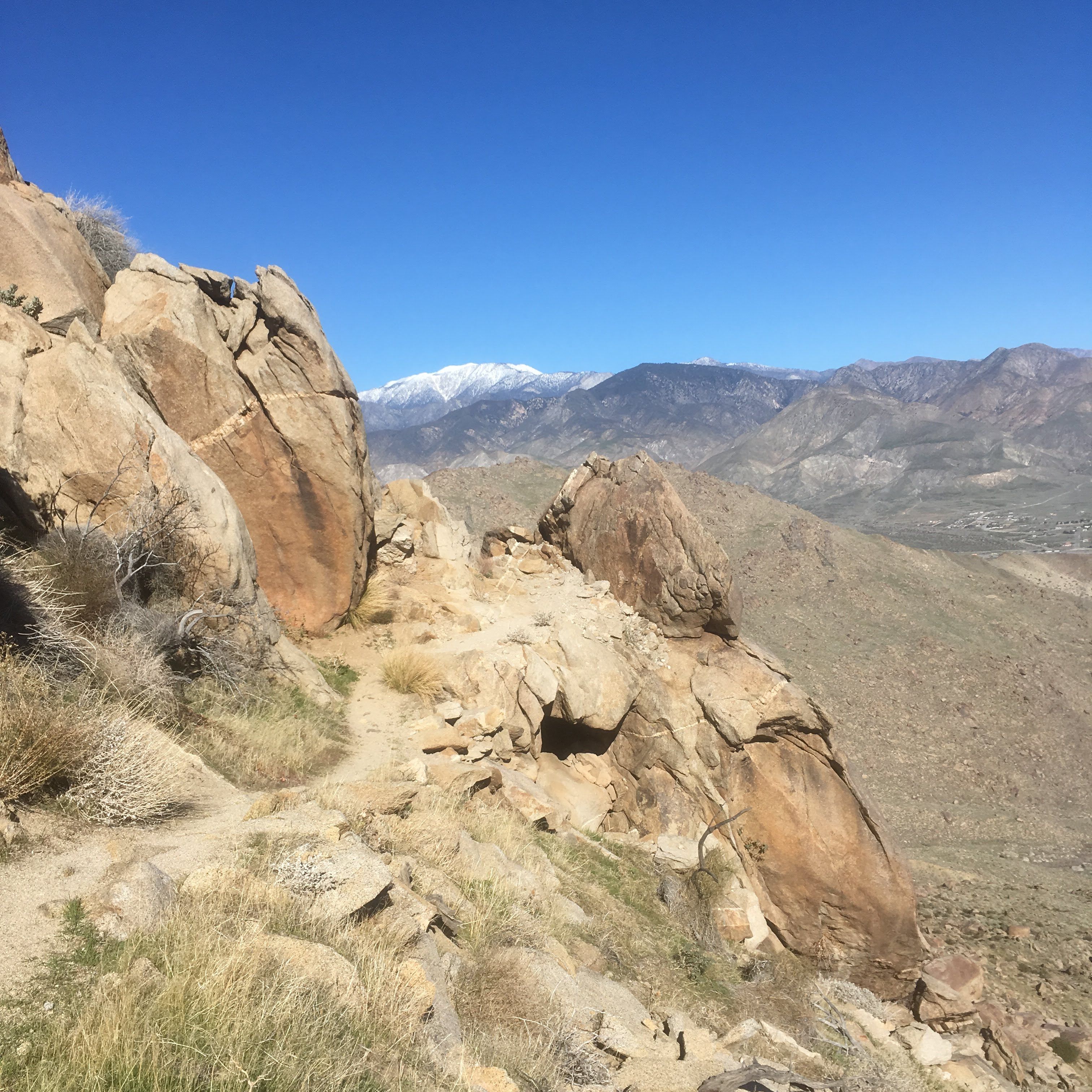
In the last mile of the hike there was a steepness that gave the trail some character.
Many of the boulders provided shade (it's a very exposed hike) and there were lots of areas that had the characteristics of human design.
This was one such area. Being on the PCT, I'm sure there has been more than a few hikers that have peeled off the trail for a break (or overnight rest). There were patches of grassy areas as well that could afford to be nice places to lie down.
After approximately five miles I found a place where the trail was saddled between the large slope to the right, and a rocky hill to the left. I chose to scramble on a few boulders to find a place to enjoy some sunshine, and have a bite to eat.
The view, more or less, from my stopping point.
This picture doesn't look like much, but it had some stunning details. The light colored slope in the very top right isn't snow. It's light covered stone rock that varies, and stands in contrast, to much of the other rocks. The valley on the left isn't very visible (the sun kept over exposing the image), but a large valley can be seen chasing around the corner towards the mountain. Completing to the trifecta of slopes, the mountains in the top left have pine trees, but the ground is covered in snow.
After admiring the landscape I nearly fell asleep. The temperature in the sun was just about perfect. I saw one other group of hikers on the way down. It was the second hike in a row where the parking area had only two cars in it (one being mine).
Doesn't look like much! However, another 8,000 ft. up from the stopping point would put me on the top of San Jacinto.
It was early in the day and I pondered how far I would be able to get if I just hiked all day. This trail had a lot to offer. The views were maintained throughout the hike and accompanied by a well maintained trail. It wasn't one of my more adventurous in the series, but it didn't disappoint either.
A few things to note
A couple things I want to mention, or reiterate. I will make them quick;
- Trail is mostly exposed. There are shaded areas behind large rocks.
- No bathroom at trailhead, but there's a rest stop on I-10.
- Don't park past the Snow Creek Village sign. They are pretty adamant about that.
Thanks for visiting the site, and I hope this was entertaining, or helpful, in some way. Please, share any thoughts that you may have!