


Introduction
With my recent move back to the desert (La Quinta, CA) I wanted to chronicle a series of hikes where I provide the information that I sought out before the hike, or discovered later, because this information was what I needed to know.
I’m 25, in decent shape, usually hike alone (not always by preference), and like to plan a decent amount. If that’s relatable, I suggest continuing. The hikes I’m choosing are for slightly more experienced hikers with sometimes a little travel time, sometimes a lot of travel time.
When I talk about weather, finding trails, or trail stats these are the apps where I get that information from:
- I find hikes mostly using the AllTrails app.
- I use Maps 3D when I’m actually on the hike (love it)
- I use NOAA Radar or Weather Bug for weather
If you are interested in other hikes that can be reached from the Coachella Valley, below are some small posts, that may or may not be useful from last winter (some might just be a picture actually).Bear Creek Oasis
- Bogert Trail to Murray Hill
- West Fork Trail – Indian Canyons
- Palm Springs Aerial Tramway
- Eisenhower Mountain
- Art Smith Trail
- Joshua Tree
- Bear Creek Oasis
- Bogert Trail to Murray Hill
- West Fork Trail – Indian Canyons
- Palm Springs Aerial Tramway
- Eisenhower Mountain
- Art Smith Trail
- Joshua Tree
- Bump & Grind
- Painted Canyon Trail
I need to add a disclaimer, that although I intend for my posts to be used as trip reports, or helpful guides, you are still hiking at your own risk. You should always carry the survival essentials, let others know your hiking/route plans, and favor caution.
Quick Stats for Hike 6
- Total Time: This excursion took ≈8.5 hours
- Date: February 11
- Driving Distance: ≈38 miles
- Hike: 14.02 miles, desc./asc. ≈1,300 ft., 6 hours 22 minutes, trailhead elevation 3,026 ft
- Expenses: National Park Entrance Fee, Food, Gas
It was dark, freezing, and I forgot my face-mask. I wrapped a small blanket around my head. I completely underestimated the wind when I left the house at 4:40 a.m. that morning. The only consolation I seemed to have were the stars I saw (and could still see) on the drive in to Joshua Tree NP, and knowing that in 3-4 hours, maybe, I would be fully basking in sunshine.
This is how my 14 mile (roundtrip) hike to Conejo Wells began. With a start like that, it didn't take much for the whole hike to get progressively better. Conejo Wells wasn't much, but I found an inspiring view, and plenty of quiet walking time along the way.
I came across the hike on AllTrails. It had a few comments. Two interesting things that I noted about them were the suggestions to just 'wander around' (because the area was cool to explore) and the difficulty in staying on the trail for the whole hike. I had to use my GPS more than I would have liked to, but I did find myself wandering down the wrong wash every now and again.
On another note, Maps 3D was bugging out on me so I didn't get an accurate elevation change. I approximated from the AllTrails data.
Destination:
Getting there
The hike is located on the south side of Joshua Tree National Park. Driving east on I-10, the exit is Cottonwood Springs Rd, and it is preceded with signage for Joshua Tree on the approach. It recommend getting gas in the desert cities before heading out there.
It takes 45-50 minutes to drive out to the trailhead (from La Quinta), but I needed to know if there were restrictions for entering the park at certain times. I wanted to start my hike very early in the morning and couldn't remember if there was a gate at trailhead, or in the main park.
In my search I came across an interesting article about how to stargaze in Joshua Tree (even if you aren't camping). Apparently, a person could drive into the park (at any hour), pull off into the one of the turnouts, and commence gazing! Pretty cool that the park allows that, because Joshua Tree is a Dark Sky Park with the International Dark Sky Association. I'm not sure if that is true for the north entrance, but certainly at the south entrance. Regardless, this information answered my question. I would be able to enter the park early.
The turn off for the trailhead is where the Cottonwood Springs Visitor Center is located. This is where park entrance fees are paid during business hours. Take the road all the way to the end (following the 'P' for parking signs). The lot is fairly small, but had plenty of parking at 5:30 a.m.
The Trailhead
The parking lot is the start to a few different hikes in the area. Technically, the trail for Conejo Wells starts here, but really, the hiker will have to follow an intermediate trail from the parking lot, to the campground (Loop B), and then out the back of one of the campsites.
Overview of Cottonwood Springs Area
The blue line route is fairly simple, and not a long distance, but can be trickier in the dark. The map shows parking at the campgrounds, but I doubt that is the most viable option.
There are bathrooms by the campground and the visitor center. There is also a rest stop on I-10 a few miles before the exit onto Cottonwood Springs Rd.
The hike
It was too damn cold, and too dark, to take sufficient pictures for the beginning navigation of this hike. On my return journey I took pictures to better show the signs for the route. That is why the pictures will look so sunny when, in actuality, I was walking past them in very dark conditions at around 5:30 a.m.
My Weather Bug app had warned me—the previous day—that there might still be windy conditions in the morning. The trailhead is, also, at approx. 3,000 ft, and I regretted not bringing a beanie or face shield.
From the parking lot, the trail starts by walking towards the road that you came in on.
Parking lot in distance. Entrance road on right.
Same sign from picture on left, just in direction that someone would start hike.
The pre-trail hike is well maintained and has many signs. The trail parallels the road for a short bit until it runs into a large sandy wash. Start walking up the wash until you come across another sign post.
This sign is in the middle of the wash. Head towards the caompgrounds (left).
Looking left from the sign you will see these steps. This is the route.
The park has added many informative signs along this section of the trail. They can be nice to read if you have the time.
Shortly, you will come across a post marked with 'A' or 'B'. Head to the right towards Loop B.
When I was doing the hike the campsites were not occupied, but this trail does lead into the back of one of the sites.
Soon, you will be on the pavement of Loop B, but not for long. Stay to the right when you hit the pavement and will, hopefully, see the trail extending out of the back of campsite B17. Again, the campsite was not occupied when I hiked, but could be.
It's straightforward—literally—at this point. The trail is sandy for the first couple miles (which I liked) and decently easy to follow. However, at one point I started walking up the wrong wash. I couldn't believe it, because I didn't even notice that I was walking through a wash, and not on a trail.
Once I got back on the trail I discovered a fundamental characteristic that allowed me to find the trail every time I ended up on the wrong path.
The trail actually used to be a road. I noticed how it seemed like the bushes were growing in a strangely straight pattern. This pattern was created because the tires would stop the growth of plants where the tires moved across the desert ground, but in between the tires plants still could grow and were less affected.
Taken in the morning, I apologize for the over exposure.
Another picture during the middle portion of hike.
Line vegetation towards destinations, again keeping me on track.
Some sort of vehicle (truck, Jeep) was driven on this path to access the wells on the other side of Eagle Mountain. If it weren't for these markings the trail would have been impossible (it was already fairly difficult) to follow due to the the amount of times it was intersected by washes.
Let's say that this trail characteristic disappears, or a hiker does find themselves off the trail without GPS to help them get back, there would still be a general way to navigate this trail due to the distinct landmarks.
Screenshot from Maps 3D. Redline indicates hiking route.
Looking at the picture above, one can see that the trail is shooting-the-gap between Eagle Mountain (the larger mountain area that Conejo Wells is a part of) and the smaller rocky hills on the left side of the red-line in the picture. Both these landmarks are easy to find. I knew that if I got off trail I wouldn't be lost.
After the second mile, or so, it became much lighter. There has been a high amount of rainfall in the area this winter and it was astonishing the amount of green vegetation that was on (and all around) the trail. I couldn't believe how much grass, weeds, and other greens that covered the 'desert'. I was hoping for a nice desert sunrise, and I got one. However, Eagle Mountain hid the sun for good part of the hike.
In the first three miles the trail is gradually gaining elevation on a ridge before descending down through the gap. It makes for a nice view of desert and mountains to the west.
At approx. 2.7 miles (from the parking lot) there is a large boulder. This would be a great destination for a shorter hike because it's easy to climb and get a view. It would also prove some shade later in the day.
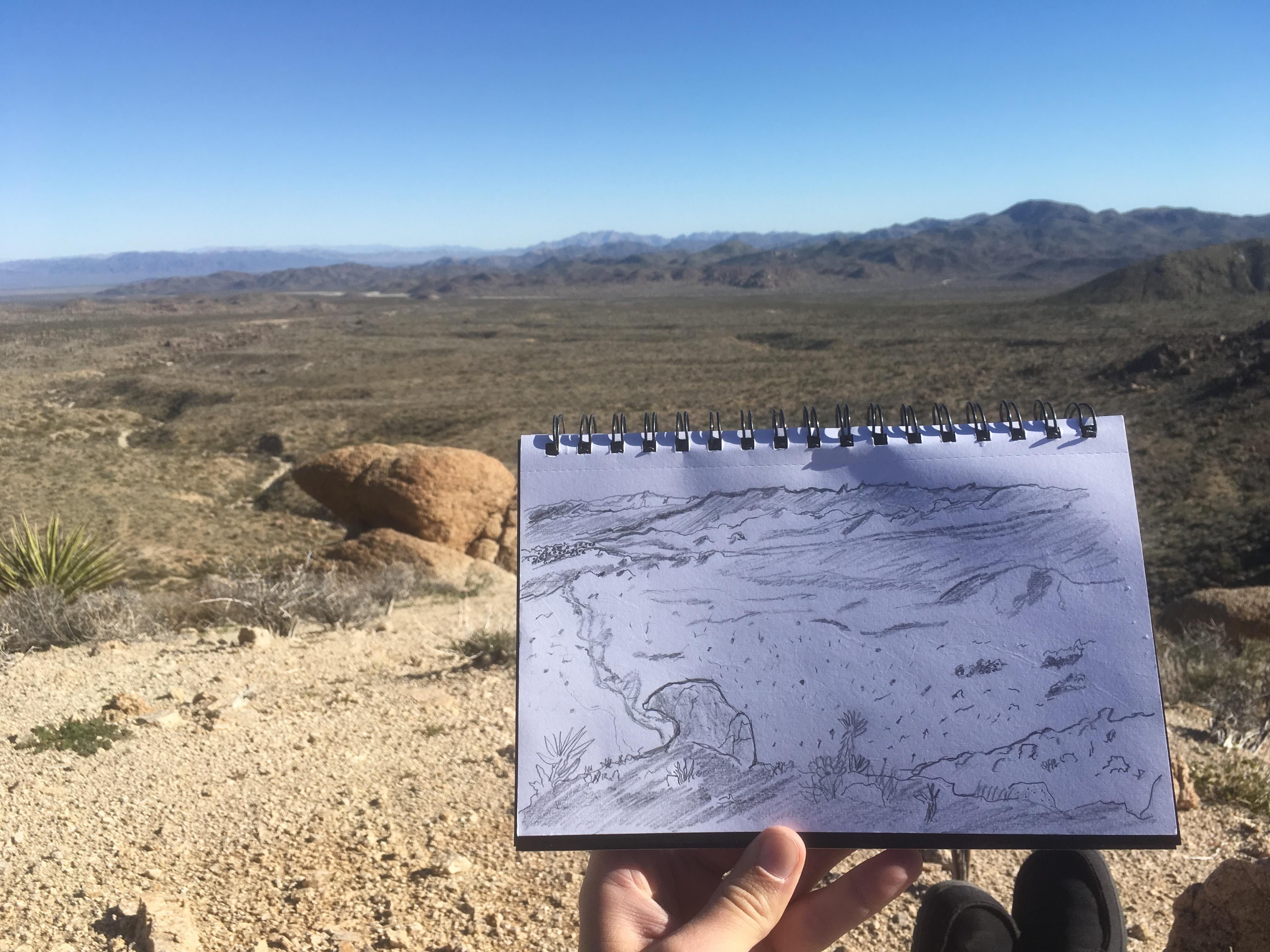
Panorama below was taken from top of boulder. Directionally, the image is warped, but it does convey the ease that landmarks can be spotted.
A little further, just past the three mile mark, starts a series of larger wash areas. There are some cool rock formations here, and also provide a nice stopping point, or break area. The trail becomes more rocky and increasingly difficult to follow. I only saw two cairns along the route, but built one myself at a larger wash crossing.
In between the mountains (in the gap) it was impossible for me to stay on the trail. It's also not completely necessary because everything is the going the same direction (all the wash routes).
Large wash area leading further into the back country. Approximately 4.5 miles in.
Rock pile in ‘gap’ area of hike
In the gap there is a large, stand-alone, rock pile that acts as another helpful landmark on the excursion. It finally started to warm up as I walked through the gap and around Eagle Mountain. I even had thoughts about going up the mountain! However, I stuck with my original hike plan.
As it would be, my phone became very low on battery in this section of the hike. I was glad I brought a portable charger (beyond glad actually) that quickly gave it strength again. This was also where Maps 3D bugged out on me, and the elevation went up to 13,000 ft somehow. Hope it doesn't happen again.
Something else happened, as I walked through the gap between the major landmarks. I got the chills. I realized that, besides being a gap, it resembled a gate. I didn't expect to see two large desert valleys—as I came out the other side—bordered by layers of ascending mountains. Far in the distance I could see more jagged peaks, and it added a powerful accent to the scene.
Now on the back side of Eagle Mountain, I began looking for where the trail was going to cut back up in the the hills.
There are two large washes that can be used as checkpoints once on the other side of the mountain. The first wash is fairly wide at around 30-40 ft across. After walking across that one, you will continue past some small hills on the right. If you have stayed on the trail there will be a trail junction to cut up towards the mountain.
In this shot, you can see the trail junction branching off to the right. What is nice about is the large wash (denoted by the blue squiggly line) is this is where the water from Conejo Wells flows from. So, the trail is just above and on the right side.
I had lost the trail just before the branching off, but quickly realized it, and moved up to higher ground where the trail was.
At this point it is fairly intuitive as to where the wells are going to be located. But, just for reassurance, I took some pictures to illustrate landmarks.
This was the longest hike that I had gone on for the hiking series so far. Despite the record setting distance there was not a whole lot going on at Conejo Wells. I had to double check my maps to see if I really went far enough. It is a cool area, however, with large rocks providing shade and areas to hang about. I'm sure that it provides protection from the wind as well.
Large wash that will be on your left in final stretch of hike.
There were a few rusty pipes protruding from the ground at the hike destination.
I haven't talked too much about the vegetation on the hike, but this is where I really took some time to photograph the cool variety of cacti that I had been hiking around.
Some cholla cacti with a view.
After 7.2 miles and 3 hours/5 minutes on the trail I needed to find a destination to take a break. There is a small hill up to the left (looking back down into desert valley) that I figured would be a great spot. The picture below shoes the hill, illuminated by sunlight on the left.
This picture was taken from where I believed the destination of ‘Conejo Wells’ to be.
As I began to head up the short slope it seemed that the hill been climbed before, and when I got to the top I could tell that this would be a great place to sit down for a break.
Break area with a view just above Conejo Wells.
The desert, when it isn't windy, can be psychotically quiet. There were times where I stopped just to check and see if anything else was making a sound. Put another way: it's incredible peaceful. At this spot I had a tremendous view of the ascending rows of mountains across the valley to the west, and a lower desert valley to the northeast. I was tired, and knew there would be a long trek back. However, the sun felt perfect, and I stayed up there for almost 45 minutes. I was relaxed, and better hydrated, when I decided to begin my walk back.
The view from top of hill that provided vantage point. The wash behind the large rock in the foreground is the one that runs, more or less, parallel to the trail for a little.
The return journey was uneventful (now that I had a good idea of how the trail maneuvered). I chipped away at the walk back. It did—despite the very cold morning—get hot on the way back. It was a cold, hot, windy, silent, and enjoyable excursion.
A few things to note
- Exposure. There is not that much shade on the hike, and the sun can really beat down on.
- There is a good amount of cacti, or other pointy bushes, on the side of the trail. I found many pricks on my legs the following day.
- I brought 80 fl. oz. of water and 24 fl. oz of Gatorade. I still had 30 fl. oz, or so, left over after the hike. I spent a majority of the time hiking in the morning, being much colder, so I had the majority of that when I stopped and on the return trek.
- I was very thankful I had my portable phone charge with me on this hike, being that it was longer and took more time.
- The Conejo Wells trail has areas to shorten this hike down, and still provide an interesting view or walk.
- Parking lot isn't that big, and was full when I got back around noon.
Thanks for visiting the site, and I hope this was entertaining, or helpful, in some way. Please, share any thoughts that you may have!