


Introduction
With my recent move back to the desert (La Quinta, CA) I wanted to chronicle a series of hikes where I provide the information that I sought out before the hike, or discovered later, because this information was what I needed to know.
I'm 25, in decent shape, usually hike alone (not always by preference), and like to plan a decent amount. If that's relatable, I suggest continuing. The hikes I'm choosing are for slightly more experienced hikers with sometimes a little travel time, sometimes a lot of travel time.
When I talk about weather, finding trails, or trail stats these are the apps where I get that information from.
- I find hikes mostly using the AllTrails app.
- I use Maps 3D when I'm actually on the hike (love it)
- I use NOAA Radar for weather
If you are interested in other hikes that can be reached from the Coachella Valley, below are some small posts, that may or may not be useful from last winter (some might just be a picture actually).
- Bear Creek Oasis
- Bogert Trail to Murray Hill
- West Fork Trail – Indian Canyons
- Palm Springs Aerial Tramway
- Eisenhower Mountain
- Art Smith Trail
- Joshua Tree
- Bump & Grind
- Painted Canyon Trail
Quick Stats for Hike 3
- Total Time: This excursion took ≈5 hours
- Date: December 12
- Driving Distance: ≈32 miles
- Hike: 6.87 miles, desc./asc. ≈1,754 ft., 3 hours 43 minutes, trailhead elevation 2,250 ft
- Expenses: Food, Gas
This hike such a subtle elevation gain that, for a second, I didn't believe it when Maps 3D displayed that I had already gained over 1,000 ft in elevation. Anyway, the transition from a dry desert river bed to a more colorful canyon stream was amazing. I did not expect the fall colors in December, but welcomed them as they made the hike even more special.
I will also remember this hike as, "the one with the cows". I'll get to that story later.
The hike was definitely a mild adventure, and the least extreme of the first three hikes. Although dull, it was enjoyable, and I had never hiked North of I-10 in the Whitewater Preserve. Ok, here we go.
Destination:
Getting there
I already mentioned that this hike started at the Whitewater Preserve, which is pretty easy to get to, and can be seen on the above map.
The preserve, and it's history, is pretty cool. Information on the preserve can be found on it's website. Most of the context of the preserve can be summed up in this paragraph:
WHITEWATER PRESERVE
Whitewater Preserve is 2,851 acres surrounded by the Bureau of Land Management’s San Gorgonio Wilderness, and includes the year-round Whitewater River. Rich riparian habitat hosts the endangered Southwest willow flycatcher and Bell’s vireo, and provides opportunity to see migrating summer tanagers and vermilion flycatchers. The canyon has a robust population of bighorn sheep, deer and bear, and is an important wildlife corridor between the San Bernardino and San Jacinto Mountains. The Conservancy purchased an additional 3,200 acres in the Whitewater corridor that was donated to the Bureau of Land Management. These donated lands include sand dunes that are home to the endangered fringe-toed lizard at Windy Point, which lies at the confluence of the Whitewater and San Gorgonio Rivers.
What you need to know about the preserve is:
- It's open from 8am - 5pm, so you'll have to wait until 8am to access the trailhead.
- They have bathrooms, a picnic area, and limited parking space (they recommend carpooling).
- It does not cost money to visit the preserve.
- It is affected by rainfall. The trail crosses dry creek beds, and might get shut down if it rains.
The preserve building area was gorgeous. It's right next to a massive cliff with lots of tree coverage.
The exit to take off of I-10 is the Whitewater exit (Mile 114) and it's pretty straight forward (there are a couple signs) that direct you how to get to the trail head. It's not that far from La Quinta. I made the drive in 40 minutes and ended up waiting at the gate for a couple minutes which was no big deal.
The trailhead
I already mentioned a few important facts about trailhead, and I'm sorry if I repeat some of them:
- There are a good amount of parking spots, but it's popular, so they recommend carpooling.
- They have bathrooms and tree covered picnic areas. Check out the image of the picnic area below
The trailhead starts across the street from the visitor building. There is a clean looking—man-made—pond that uses some of water that flows from the water shed. They ask that all hikers sign-in, which I was on-board with, and they have a sign-in a little further up past the bulletin board at the start of the trailhead. They also have a sign-in inside the building if you don't mind saying hello to the friendly attendants.
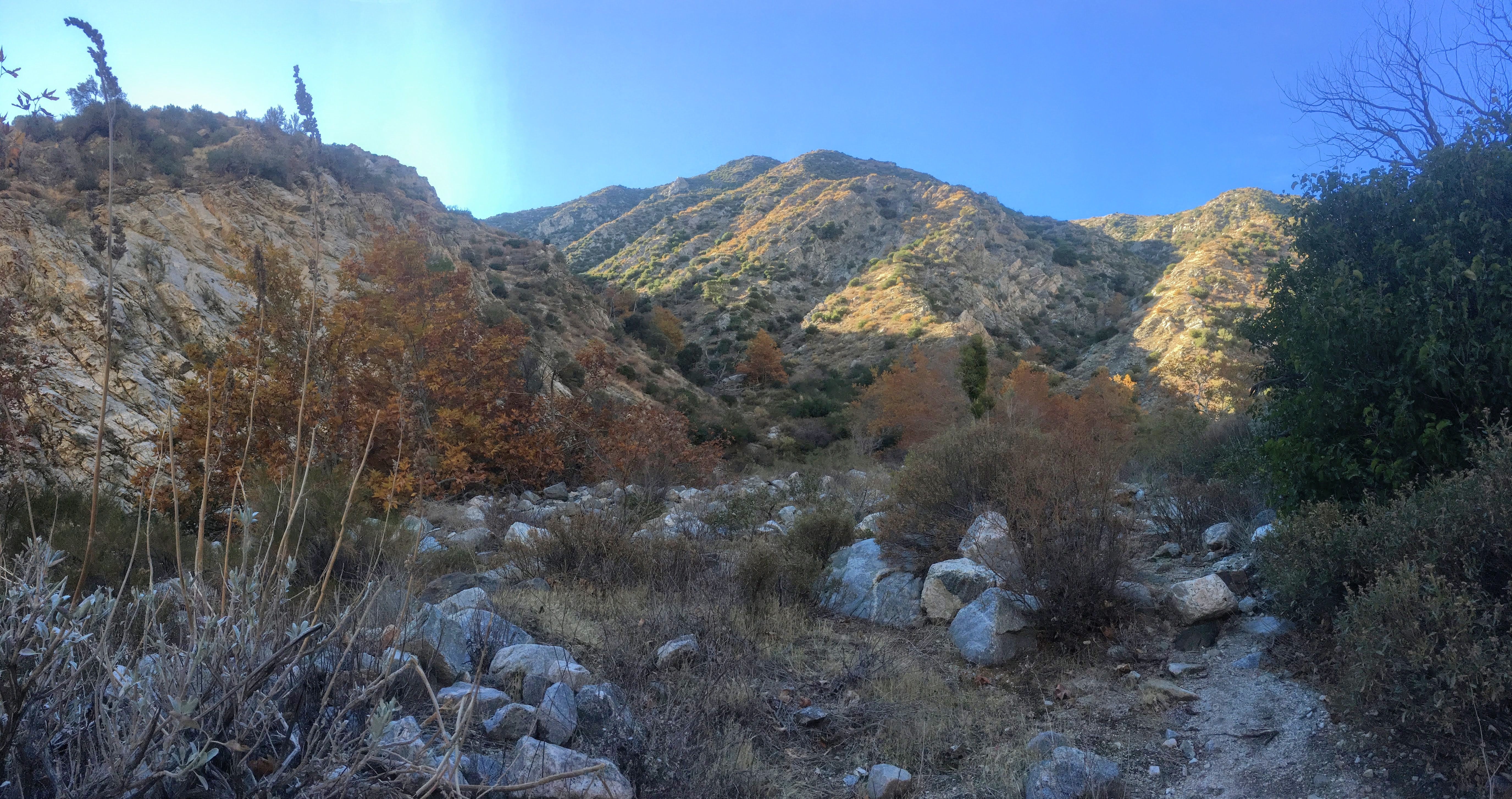
The starting area of the trailhead is really nice, especially with the fall colors, and is right next to a massive cliff with a few contrasting rock layers. Below are some pictures I took starting out.
The hike
There are a few things I want to say about the hike before I get any further.
- The trail is well marked.
- You hike a little bit on the PCT (which is kind of cool).
- There isn't that much shade until later when you get deeper into Rainbow Rock Canyon.
- I probably could have gone without my hiking poles due to the steady elevation change.
Above is a screenshot of my phone in the Maps 3D app. The fainter red line running horizontal on the map is the PCT.
There is a compass in the upper right.
I saw this rock, starting out on the hike, and thought they were being cute when they listed the distance for Mexico and Canada, but was then reminded that the PCT ran through this trail area.
There is a small junction/intersection of trails at the beginning of the hike that led me astray for a moment (that is where I saw the cows), but the trails are marked with good signs.
The first sign that you will come to is this one. I went left, for reasons unknown to myself, but—obviously—go straight.
After I went left, I heard a noise (before I turned around and went back to the above sign), and realized that what I heard was cows. There were maybe five of them, and as I went to turn around they started stampeding up the dry river bed. This was startling to me because free range cows were not on the menu. I had also seen the movie Lion King, and am fully aware that hooves killed Mufasa (as well as Scar). Anyway, along the trail I saw lots of "cow pies" and hooves tracks that put me on edge.
It's embarrassing to say, but these cows had me rattled, because I couldn't quite see that well (due to the foliage) and I didn't want to sneak up on a small herd of cows by accident. After a mile-and-a-half on the trail I saw the cow that I had been tracking (or believed to be tracking).
This cow caused me enough distress to be classified as a "saber tooth rattle cow", which is a reference to my childhood. The fable was told by my cousin Jesse of a "saber-tooth-rattle-squirrel". It was told to invoke fear into his brother. Therefore, a seemingly innocent looking species can have a ferocious cousin if your imagination is willing. Ok, I have seriously digressed.
In all seriousness, there are cows on this trail, and they run around sometimes, so be on alert.
Above is the next sign that you will come to, and it is supplemented by a post that says "Trail" on it. Take a left here to begin the next section of the trail.
The next section of the trail leads you across the dry creek bed and up to the other side. You will walk along this section until you come to PCT trail junction marked by the below two signs.
I should mention that all these trails are probably within the first mile of the hike.
Continue straight after these signs towards RED DOME. The trail will fork before RED DOME, and you will go left towards Rainbow Rock Canyon.
This whole area is the dry Whitewater watershed area. It makes up a large section of this hike. The part where the trail breaks off to the canyon is unmarked. I found the place to merge away from the trail at this point..
Nice shadow, right? Look for the post 40-yards up in the distance on the trail in order to gauge when this trail goes left. If you reach that post you have gone too far.
The trail starts to head into the canyon, slowly gaining elevation, the walls getting closer, and ecology starts to change. There are also easily visible game trails up into the hills. There are apparently many bighorn sheep, deer, and other animals in the preserve.
As I hiked further into the canyon the hike become more-and-more interesting. I was walking in the shade with deciduous trees that had orange leaves! The color green was more prevalent on the hills, and the canyon kept becoming more narrow with taller brush.
The trail was still pretty easy to follow, but I had to begin ducking branches. There was a small stream that made the ground a little muddy. This stream will fluctuate depending on the weather, so be prepared for varying levels.
This lone pine is a true sign of the transition zone.
I was finally hiking with the rock walls of the canyon right next to me.
As I hiked deeper into the canyon the trail became very cool and I almost put my jacket on.
The stream was a constant background sound, and I knew that I was approaching the destination of my hike.
Ladder + rope to help scale the small water fall.
I had reached this spot in right about two hours. I did some more exploring around the area before sitting down to eat, sit in the shade, and sketch. The stream runs over the top rung of the ladder, so I did get a little wet.
There are two levels that need to be climbed to continue past this point (if you wish).
Here is the second level climbing mechanism. Metal bars shoot out from the rock accompanied by a rope.
After about half an hour I began hiking back. My attention kept focusing on the colors of the trees on the hike.
The trail made a lot more sense on the way back (and I wasn't as worried about the saber-tooth-rattle-cow).
Looking towards the main wash of the Whitewater Preserve.
I was hiking back along the trail, letting my mind wander as it tends to do, when all of the sudden I saw the most amazing rock! I couldn't believe it. The whole time, I had thought the "Rainbow Rock" part of the trail name was referring to the colors of rock walls by the ladder. Then I saw this on the trail..
A freaking rainbow rock.
It took me just over an hour to complete the trail on the descent. I took a nice picture that shows that trees by the preserve buildings as well as the cliffs behind them.
The yellow trees are where the picnic are is. I read that sometimes goats/sheep can be spotted above on the cliffs.
It was nice to hike in an area that had some more color. The hike did not see strenuous to me, and is definitely more of a mild adventure. For the next hike, I need to decide if I'm going to go back into the desert, or chasing some snow in the San Jacinto Mountains. Time will tell!