


Introduction
With my recent move back to the desert (La Quinta, CA) I wanted to chronicle a series of hikes where I provide the information that I sought out before the hike, or discovered later, because this information was what I needed to know.
I’m 25, in decent shape, usually hike alone (not always by preference), and like to plan a decent amount. If that’s relatable, I suggest continuing. The hikes I’m choosing are for slightly more experienced hikers with sometimes a little travel time, sometimes a lot of travel time.
When I talk about weather, finding trails, or trail stats these are the apps where I get that information from:
- I find hikes mostly using the AllTrails app.
- I use Maps 3D when I’m actually on the hike (love it)
- I use NOAA Radar or Weather Bug for weather
If you are interested in other hikes that can be reached from the Coachella Valley, below are some small posts, that may or may not be useful from last winter (some might just be a picture actually).
- Bear Creek Oasis
- Bogert Trail to Murray Hill
- West Fork Trail – Indian Canyons
- Palm Springs Aerial Tramway
- Eisenhower Mountain
- Art Smith Trail
- Joshua Tree
- Bump & GrindBear Creek Oasis
- Bogert Trail to Murray Hill
- West Fork Trail – Indian Canyons
- Palm Springs Aerial Tramway
- Eisenhower Mountain
- Art Smith Trail
- Joshua Tree
- Bump & Grind
- Painted Canyon Trail
I need to add a disclaimer, that although I intend for my posts to be used as trip reports, or helpful guides, you are still hiking at your own risk. You should always carry the survival essentials, let others know your hiking/route plans, and favor caution.
Quick Stats for Hike 8
- Total Time: This excursion took ≈9 hours
- Date: March 15
- Driving Distance: ≈22 miles (from La Quinta)
- Hike: 12.7 miles, desc./asc. ≈2, 916 ft., 7 hours 52 minutes, trailhead elevation 4,440 ft.
- Expenses: Food, Gas
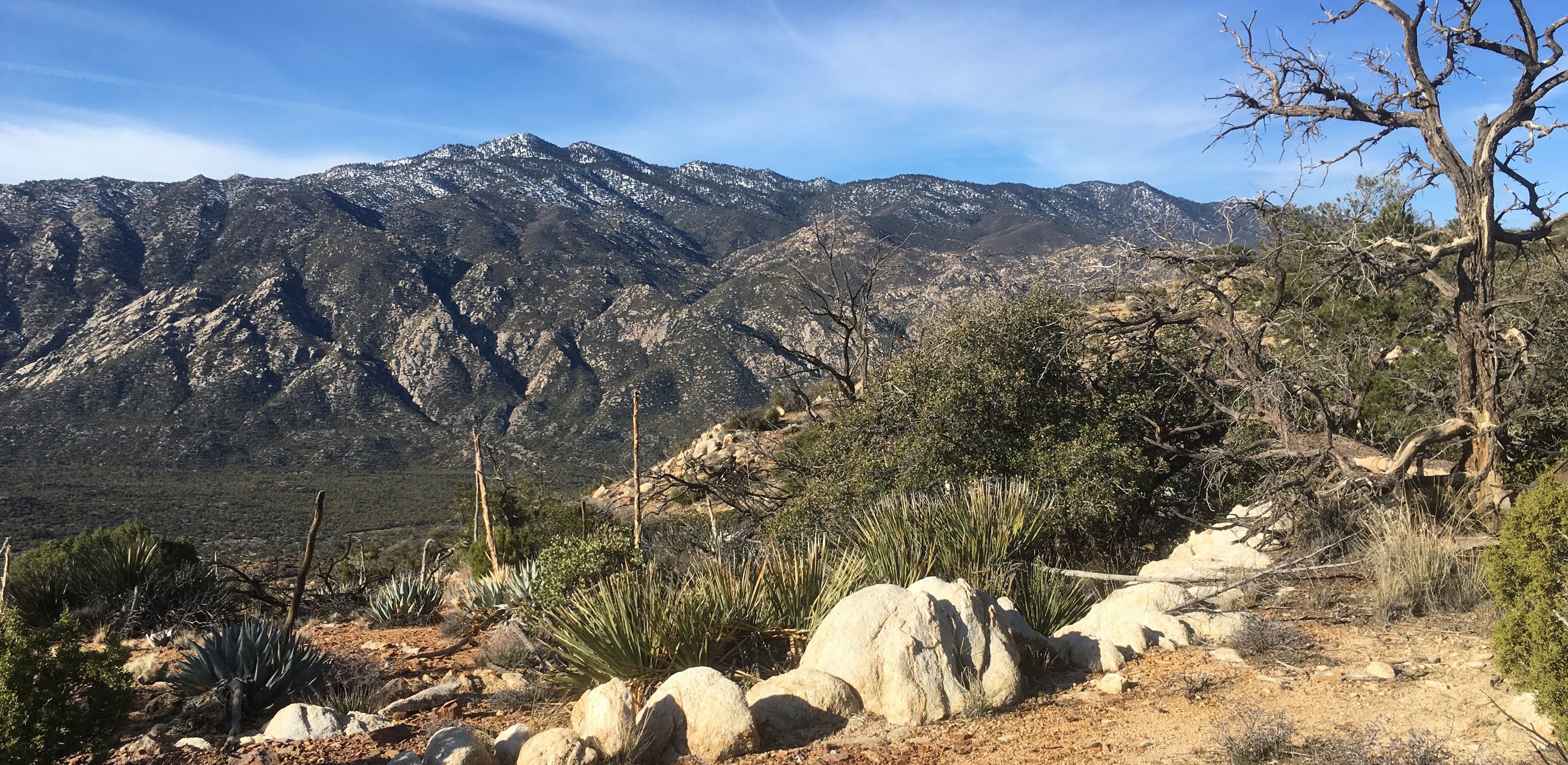
I was surprised how frustrated I was, but how easily I could turn around to the landscape behind me, and be eased into a feeling of awe. The green valley stacked above the desert—and below Santa Rosa Peak—is nothing short of a hidden gem.
However, this hike had an open-ended test question on it, and I stumbled through my response. In the end, I was able to figure it out, and I feel better for it. The description on all trails reads, "[...] only recommended for very serious adventurers." For the most part, it's not that wild, but the need for solid route finding—and some endurance—are a prerequisite, or the hike may be a struggle.
This hike reminded me of my Traveler's Peak climb back in Hike 2. It fell into the same category for a number of reasons that makes it a special hike. I really fell in love with the area, too, and spent a lot of time standing and enjoying the scenery. I have much to talk about with this one, so I will get started!
Star marks the trailhead, which is just off Highway 74 near Pinyon Pines.
The below GPX track and information were corrupted during the hike. It only shows my ascent to Sheep Mountain, and even then there is a section of GPS coordinates that is missing.
Destination:
The Trailhead
The trailhead is relatively easy to find. Traveling on Highway-74 up, and out, leads one right to the road that has signage for the "Sawmill Trailhead".
The Sawmill Trail, and Cactus Springs Trail, are the two most popular from this trailhead.
Once off of 74, there is a nice sign marking the left hand turn into the fairly spacious (and gateless) parking lot.
Heading out of the east side of the parking lot (the back) takes one to a dirt road that comes to another dirt road (intersecting the first dirt road) running north-to-south. From here, it's fairly easy to see the signage for the Cactus Springs Trail (the one that needs to be taken). Missing this sign, and continuing south would be the Sawmill Trail.
I started the hike in the dark, again, so most of the pictures for the signage were taken on the way back.
The sign on the right, slightly higher, indicates that the Sawmill Trail is to the right, and the Cactus Springs Trail is to the left (straight through). The Sheep Mountain hike is on the Cactus Springs Trail for over four miles. In the dark, the start of the trail can be pretty uneven.
The Hike
I've talked before about how wonderful it is to start a hike in the morning. The trailhead is just past the Cahuilla-Tewanet Scenic Overlook which is a great place to stargaze. The sky was clear and well lit with many of the more shy stars, especially to the south, just above one of the higher points of the Santa Rosa Ridge.
I thought this hike might be like my Joshua Tree hike, due to the starting elevation and desert climate, but the wind was almost nonexistent, making the hike mostly quiet, except for the occasional car driving along Highway-74. I cannot deny that I was a little nervous. The hike descends at first before rising quickly up and away from Horse Thief Creek.
It was nearly pitch black in the valley that I would be descending into, which was also an unfamiliar place, and I was alone. All that considered, I figured my nervousness was warranted. I had my headlamp on which illuminated the hybrid environment around me. There were cacti, interesting pine looking trees on both sides of the trail. The trail is easily to follow, and signage is fantastic for the whole time that I was on the Cactus Springs Trail.
The first two miles of the trail gradually descends toward Horse Thief Creek in a series of half-mile steps. What surprised me at the time, because I wasn't wearing waterproof shoes, was that I would be crossing two or three streams in the first part of the trail.
This was one of the first signs I came across once on the trail. I didn't record its distance exactly, but it was before the scream areas. The trail is pretty well maintained and easy to follow.
I imagine this is referring to either the heat in the small valley, or flooding that can occur with a big rain.
There has been a good amount of snow in the mountains, and with the warmer temperatures, the streams have a good flow to them. All of them were easily crossed by stepping on rocks.
I thought the placement of this sign so far down the trail was interesting. It precedes the Horse Thief Creek area, but not by much.
I was pleasantly surprised by the size of the valley that surrounds Horse Thief Creek. I have driven many times on Highway 74, but have been mostly unaware of the environment below. This area has been carved out by the water coming off of the Santa Rosa Peak ridge, and marked the steepest/longest part of the hike.
"Standing on a rock in the middle of the creek."
This ‘Trail’ post was on the other side, and I would begin to see many more of these.
Horse Thief Creek was about 2.3 miles from the start of the hike, and it was approaching sunrise. I made my way across the stream, but wanted to hurry up the east side (pretty steep) in order to get a better view of the orange/red colors. I broke a good sweat and hustled up the other side.
Further below is Horse Thief Creek, and across the valley, at the base of the prominent hill straight ahead is Highway 74.
I enjoyed the sunrise for a bit, looking up the elevation, and name, of Santa Rosa Peak to the south. It's elevation is upwards of 9,000 ft and Maps 3D shows a few camping areas at the top.
After plateauing above the creek, the trial becomes a sandy wash area for a stretch as it works it way east and up.
This is an enjoyable part of the hike. The trail increases steadily, and the ground was soft, but wasn't sandy like a beach. The surrounding vegetation was surprisingly green. In some areas the walls rose high enough to provide shade.
Picture of the wash part of the hike showing the ‘hybrid’ environment that was a nice surprise.
I had no trouble on the trail heading out, but coming back I missed a turn where the trail drops transitions up (or down) a slope. The turn is at approx. 2.75 miles (from the trailhead) and is clearly marked with one of the 'Trail' wooden posts. On my way back down, I found myself in an unfamiliar wash, and remembered where I had made my mistake.
Despite that small detail, the trail rises out of the washes to the base of the valley. I stopped multiple times as I sauntered through this section of the trail. The morning sun was hitting Santa Rosa Peak range and the valley was a dark green expanse that was also guarded by Martinez Mountain on the west. I was in shock at how picturesque it all was. It was an impressive hidden landscape. The combination of impressive views with morning sunshine reminds me of the quote, in Walden;
“Morning is when I'm awake, and there is dawn in me.”
Henry David Thoreau
It’s difficult to see the sun up at the top of Santa Rosa Peak (straight ahead), but there’s a decent amount still there.
At 4.3 miles, there is a small fork, and this can be confusing because it is fairly close to where the hiker will be shooting off to the left towards Sheep Mountain.
Stay to the right, following the ‘Trail’ post at 4.3 miles.
At 4.6 miles, there will be another area that looks like it is a fork in the trail. There is a small wash coming down off the slope to the left and that is the direction that one will want to take. Over to the right, down the trail a bit, there is yet another 'Trail' post. This would be the direction to continue on the Cactus Springs Trail.
Left is the trail to Sheep Mountain. Right to continue on Cactus Springs. Picture is taken looking east towards Martinez Mountain.
After veering off the main trail, things get interesting. The trail parallels the wash for the blink of an eye before merging with it. The wash is narrow at first, but gets pretty spacious.
The wash wanders uphill and slightly to the right towards the hill with the sharpest prominence.
The hill I am talking about is straight ahead in the picture on the right, and is further east than it's more rounded neighbors that are on the same ridge. This ridge needs to be navigated before Sheep Mountain peak comes into view.
Unfortunately, I took a smaller wash on the left (off the main wash) too soon. This pointed me at the smaller rounded hills to the left of the guiding point.
Once I realized that I had made the mistake, I figured that it would be ok, but I would have to do more work to get up and over the ridge ahead.
Things might have begun to get confusing, so I'm going to do my best to clear them up with a screenshot from Maps 3D.
Screenshot of Maps 3D with text and other objects added to help explain navigation.
Maps 3D bugged out on me again so I restarted the navigation from the top of Sheep Mountain. The following list is for the picture above;
- Red line is the route that I took on the decent. This is the route that should be taken.
- Black line, is an estimation of my route on the way up, which took way too long.
- Yellow dashed lines, mark the two ridge lines that are important vantage spots and divide sections of this part of the hike.
- 'Aiming Point', is the pointed hill that should used to direct travel through the wash.
- 'Rocks', denotes two large rock structures that will be used as important landmarks.
I mentioned that I veered left too soon and had to struggle to get to the right as I crested the first ridge line. In front of me was a small bowl that offered a route finding opportunity.
‘Small bowl’ that I referenced above. I’m standing on the lower ridge line, with the area in between the ridge lines in front of me The ‘Rocks’ are out of view to the left.
Once over the first ridge line, it's important to not drop down into the wash below, or cross over towards the landmark rocks on the left. Stay on the right side of this area and traverse the slope. Here, you will find trails (some game trails) that make it easier to cross this section.
On my ascent, I was trying to follow the AllTrails redline, and it lead up me straight up the steepest part past the landmark rocks.
‘Rocks’ as denoted on the screen shot edited image.
Photo taken while resting on the ascent.
I was frustrated with my current position, but I couldn't deny the gorgeous view behind me.
Instead of being this close to the landmark rocks, and on a very steep part of the slope, the hiker should be further on the east side of this section.
Photo taken on the decent.
Photo taken at the second ridge line on the descent.
The above image shows the hikers relation to the rocks from the second ridge line. Here, one can see how far off I was. Let's take a look at the map again.
Screenshot of Maps 3D with text and other objects added to help explain navigation.
I came across a few cairns as the trail made it's way up from in-between the two ridge lines. From the top of the second ridge line I was able to see Sheep Mountain.
From here, the trail drops down in between Sheep Mountain and the second ridge.
Cairns were on a few rocks during the final ascent.
I did not find a clear trail here, either, but I came across a few cairns (white rocks mostly) that were placed along a route. Again, it seems to be beneficial to favor the right (east) side of area that is being crossed.
Compared to the previous terrain, and effort, the final part of the hike was fairly casual. When I arrived at the top I had been hiking for 3 hours and 33 minutes.
Cairn at the top of Sheep Mountain.
I was finally able to see the valley spread out beneath me. The Salton Sea was visible sliding out from the side of Martinez Mountain. Further down the slopes to the north I could see La Quinta, and Eisenhower Mountain.
Looking northwest, I could see the golf courses Stone Eagle and Bighorn. The San Jacinto Range and San Gorgonio were also visible in that direction. More to the west, and closer, I could see Highway 74 as it snaked up the slope, and even back along the hike to almost where I began.
View from the top starting to from the northwest (left side) to the mostly east (right side) .
My favorite view, however, was behind me (south) towards Santa Rosa Peak.
Santa Rosa Peak in distance, with Sheep Mountain summit cairn in the foreground.
There was quite a few things to explore at the top. I was fairly tired, and the sun was just about perfect with a light breeze. There was also plenty of room to sit down for a comfortable rest.
Some animal bones had been carried up by a hiker, and like the Traveler's Peak hike, a hiker's log book! The oldest date I saw in the book went back 1967!
There were two or three different logs inside the plastic bags, which were inside two rusted tin cans. Unfortunately, moisture had gotten into the plastic bags, so the older notebooks were very fragile and the metal rings were rusting. I took the notebooks out, dried the inside of the plastic, and set the notebooks out to dry a little in the sun as I sketched.
Sketch held up in front of landscape that I was trying to sketch.
I spent almost an hour at the peak! It was surprising to see that I had been up there for 55 minutes, but the views (and conditions) were spectacular.
On the return journey, I spent time photographing the 'better' route that I described above. One aspect of the hike that I hadn't mentioned yet was the large amount of ram hoof tracks, and scat, that I saw in the area. However, I came across some other tracks that I wasn't so sure about, and gave me a little scare.
Animal tracks off of the Cactus Springs Trail
I'm certainly no expert on tracks, but these weren't the typical tracks I had seen on trails before. It's very easy to mistake dog tracks for something more exciting, but I wasn't necessarily close to the Cactus Springs Hike. The tracks didn't have any human boot print around them, were found in the same area of some ram tracks, and were a couple inches in width.
I'm, also, not completely rehearsed environmentally on what could be in the area. They could very well be coyote tracks, but they could also be bobcat tracks (Wildlife in Santa Rosa Widerness). They were a few inches in diameter, and the most difficult thing to determine, is whether the tracks exhibited claws.
Besides that excitement, there wasn't much else noteworthy during the hike back. It was quite a long hike, at over 12 miles, but the weather was beautiful and I had time. I wandered off trail by accident, like I mentioned earlier, approx. 2.75 from the trailhead and was quickly able to remedy the problem. As has been the case so many times before, I was basically the only person on the trail. When I was within 100 yards of the parking lot (on the way back) I briefly talked to a few people, but those were all I saw.
It was a long day on the trail, but I was completely satisfied with my hike selection and the opportunity it gave me to explore a new area.
A Few Things to Note
- The hike is exposed for the most part. Sun protection is recommended.
- I had plenty of water on the hike, carrying almost 80 oz., but I ate all my food. I usually try to bring extra (for safety reasons) but due to the length of the hike I underestimated how much calories I needed.
- This hike did not have a restroom at the trailhead.
- I was surprised by the stream crossings and, depending on the weather, Horse Thief Creek could be difficult to cross.
- The longer hike also caused me to break out the portable charger again (very useful).
- The Cactus Springs Trail is pretty well maintained (incase I didn't mention it enough earlier)
Thanks for visiting the site, and I hope this was entertaining, or helpful, in some way. Please, share any thoughts that you may have!